
2007 Guatemala earthquake
Encyclopedia
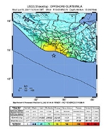
The 2007 Guatemala earthquake occurred on June 13, 2007 occurred at 19:29:46 UTC (13:29:46 local time
). The epicenter
was located in the Pacific Ocean
, south of Puerto Quetzal
, about 115 kilometres (71.5 mi) south-southwest of Guatemala City
.
The quake was reportedly felt in Guatemala
, El Salvador
and parts of Mexico
. The quake caused a minor landslide on the Inter-American Highway, and small number of houses were reported to have been damaged or destroyed along Guatemala's south coast, but there were no reports of major damages or casualties.
While the USGS assigned a magnitude of 6.7 for this event, many local seismological agencies in Guatemala, El Salvador and Nicaragua
only registered the quake in the 5.5 - 6.0 range. These calculations are more accurate due to the seismographs' locations closer to the epicenter, and are in agreement with the minor shaking reported by residents.
In addition, the USGS coins all movements as earthquakes, while in Latin America, small movements such as this one are called tremors ("temblores" in Spanish). This misnomer confused the international community into thinking this event was much larger and more severe than it really was.
UTC-6
UTC−06 is an identifier for a time offset from UTC of −06. This time is used in:-Central America:*Belize*Costa Rica*El Salvador*Guatemala*Honduras*Nicaragua-Central Standard Time:...
). The epicenter
Epicenter
The epicenter or epicentre is the point on the Earth's surface that is directly above the hypocenter or focus, the point where an earthquake or underground explosion originates...
was located in the Pacific Ocean
Pacific Ocean
The Pacific Ocean is the largest of the Earth's oceanic divisions. It extends from the Arctic in the north to the Southern Ocean in the south, bounded by Asia and Australia in the west, and the Americas in the east.At 165.2 million square kilometres in area, this largest division of the World...
, south of Puerto Quetzal
Puerto Quetzal
Puerto Quetzal is Guatemala's largest Pacific Ocean port. It is important for both cargo traffic and as a stop-off point for cruise liners.It is located in Escuintla department, alongside the city of Puerto San José, which it superseded as a port in importance to the country's maritime traffic...
, about 115 kilometres (71.5 mi) south-southwest of Guatemala City
Guatemala City
Guatemala City , is the capital and largest city of the Republic of Guatemala and Central America...
.
The quake was reportedly felt in Guatemala
Guatemala
Guatemala is a country in Central America bordered by Mexico to the north and west, the Pacific Ocean to the southwest, Belize to the northeast, the Caribbean to the east, and Honduras and El Salvador to the southeast...
, El Salvador
El Salvador
El Salvador or simply Salvador is the smallest and the most densely populated country in Central America. The country's capital city and largest city is San Salvador; Santa Ana and San Miguel are also important cultural and commercial centers in the country and in all of Central America...
and parts of Mexico
Mexico
The United Mexican States , commonly known as Mexico , is a federal constitutional republic in North America. It is bordered on the north by the United States; on the south and west by the Pacific Ocean; on the southeast by Guatemala, Belize, and the Caribbean Sea; and on the east by the Gulf of...
. The quake caused a minor landslide on the Inter-American Highway, and small number of houses were reported to have been damaged or destroyed along Guatemala's south coast, but there were no reports of major damages or casualties.
While the USGS assigned a magnitude of 6.7 for this event, many local seismological agencies in Guatemala, El Salvador and Nicaragua
Nicaragua
Nicaragua is the largest country in the Central American American isthmus, bordered by Honduras to the north and Costa Rica to the south. The country is situated between 11 and 14 degrees north of the Equator in the Northern Hemisphere, which places it entirely within the tropics. The Pacific Ocean...
only registered the quake in the 5.5 - 6.0 range. These calculations are more accurate due to the seismographs' locations closer to the epicenter, and are in agreement with the minor shaking reported by residents.
In addition, the USGS coins all movements as earthquakes, while in Latin America, small movements such as this one are called tremors ("temblores" in Spanish). This misnomer confused the international community into thinking this event was much larger and more severe than it really was.