
1966 Pacific typhoon season
Encyclopedia
The 1966 Pacific typhoon season has no official bounds, but most tropical cyclones tend to form in the northwestern Pacific Ocean between June and December. These dates conventionally delimit the period of each year when most tropical cyclones form in the northwestern Pacific Ocean.
The scope of this article is limited to the Pacific Ocean, north of the equator and west of the international date line
. Storms that form east of the date line and north of the equator are called hurricanes; see 1966 Pacific hurricane season
. Tropical Storms formed in the entire west pacific basin were assigned a name by the Joint Typhoon Warning Center
. Tropical depressions in this basin have the "W" suffix added to their number. Tropical depressions that enter or form in the Philippine area of responsibility are assigned a name by the Philippine Atmospheric, Geophysical and Astronomical Services Administration
or PAGASA. This can often result in the same storm having two names.
on May 15. It weakened over the island, but re-intensified rapidly to a 140 mph typhoon in the Sibuyan Sea
before hitting Mindoro
on the 17th. After weakening to a tropical storm, Irma turned northward to hit western Luzon
as a 95 mph typhoon on the 19th. It accelerated to the northeast, and became extratropical on the 22nd. In the Philippines Irma killed 82 people.
, Japan on the 28th as a minimal typhoon. There Kit killed 64 people, with 19 missing.
as a minimal tropical storm, and 115 mph Typhoon Ida hit eastern Japan at the same time. The two storms' heavy rain and flooding left 300 people dead or missing, with over 700 missing.
|
|
The scope of this article is limited to the Pacific Ocean, north of the equator and west of the international date line
International Date Line
The International Date Line is a generally north-south imaginary line on the surface of the Earth, passing through the middle of the Pacific Ocean, that designates the place where each calendar day begins...
. Storms that form east of the date line and north of the equator are called hurricanes; see 1966 Pacific hurricane season
1950-1969 Pacific hurricane seasons
The 1950–1963 Pacific hurricane seasons all began on May 15, 1950-65 in the northeast Pacific Ocean and on June 1, 1950-65 in the central Pacific. They ended on November 30, 1950-65...
. Tropical Storms formed in the entire west pacific basin were assigned a name by the Joint Typhoon Warning Center
Joint Typhoon Warning Center
The Joint Typhoon Warning Center is a joint United States Navy – United States Air Force task force located at the Naval Maritime Forecast Center in Pearl Harbor, Hawaii...
. Tropical depressions in this basin have the "W" suffix added to their number. Tropical depressions that enter or form in the Philippine area of responsibility are assigned a name by the Philippine Atmospheric, Geophysical and Astronomical Services Administration
Philippine Atmospheric, Geophysical and Astronomical Services Administration
The Philippine Atmospheric, Geophysical and Astronomical Services Administration is a Philippine national institution dedicated to provide flood and typhoon warnings, public weather forecasts and advisories, meteorological, astronomical, climatological, and other specialized information and...
or PAGASA. This can often result in the same storm having two names.
Storms
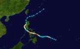
39 tropical depressions formed this year in the Western Pacific, of which 30 became tropical storms. 20 storms reached typhoon intensity, of which 3 reached super typhoon strength.Typhoon Irma (Klaring)
115 mph Typhoon Irma hit the eastern SamarSamar
Samar, formerly and also known as Western Samar, is a province in the Philippines located in the Eastern Visayas region. Its capital is Catbalogan City and covers the western portion of Samar as well as several islands in the Samar Sea located to the west of the mainland...
on May 15. It weakened over the island, but re-intensified rapidly to a 140 mph typhoon in the Sibuyan Sea
Sibuyan Sea
The Sibuyan Sea is a small sea in the Philippines that separates the Visayas from the northern Philippine island of Luzon.-Description:It is bounded by the island of Panay to the south, Mindoro to the west, Masbate to the east, and to the north Marinduque and the Bicol Peninsula of Luzon Island.The...
before hitting Mindoro
Mindoro
Mindoro is the seventh-largest island in the Philippines. It is located off the coast of Luzon, and northeast of Palawan. The southern coast of Mindoro forms the northeastern extremum of the Sulu Sea.-History:...
on the 17th. After weakening to a tropical storm, Irma turned northward to hit western Luzon
Luzon
Luzon is the largest island in the Philippines. It is located in the northernmost region of the archipelago, and is also the name for one of the three primary island groups in the country centered on the Island of Luzon...
as a 95 mph typhoon on the 19th. It accelerated to the northeast, and became extratropical on the 22nd. In the Philippines Irma killed 82 people.
Super Typhoon Kit
Typhoon Kit, which formed on June 22, rapidly intensified on the 25th and 26th to a 195 mph Super Typhoon. Such intensity is questionable, because Reconnaissance Aircraft was in its infancy, but Kit was likely a powerful typhoon. It weakened as it moved northward, and passed just east of HonshūHonshu
is the largest island of Japan. The nation's main island, it is south of Hokkaido across the Tsugaru Strait, north of Shikoku across the Inland Sea, and northeast of Kyushu across the Kanmon Strait...
, Japan on the 28th as a minimal typhoon. There Kit killed 64 people, with 19 missing.
Super Typhoon Alice
Super Typhoon Alice developed in the Western Pacific from a tropical wave on August 25. It moved to the north, looped to the west, and steadily strengthened to a peak of 150 mph. Alice continued to the west, hit eastern China on September 3, and dissipated the next day. Damage reports are not available.Super Typhoon Cora
Typhoon Cora, which began its life on August 30, attained a peak of 175 mph winds on September 5. It hit near Okinawa, causing major damage to the infrastructure on the island, but no lost of life. Cora continued to the northwest, hit northeastern China as a super typhoon on the 7th, and turned northeast to become extratropical near South Korea on the 9th.Typhoon Ida
On September 24, two tropical systems made landfall on Japan. Helen struck the southwestern part of the archipelagoArchipelago
An archipelago , sometimes called an island group, is a chain or cluster of islands. The word archipelago is derived from the Greek ἄρχι- – arkhi- and πέλαγος – pélagos through the Italian arcipelago...
as a minimal tropical storm, and 115 mph Typhoon Ida hit eastern Japan at the same time. The two storms' heavy rain and flooding left 300 people dead or missing, with over 700 missing.
1966 storm names
{|width="90%"|
|
The 1966 Pacific typhoon season has no official bounds, but most tropical cyclones tend to form in the northwestern Pacific Ocean between June and December. These dates conventionally delimit the period of each year when most tropical cyclones form in the northwestern Pacific Ocean.
The scope of this article is limited to the Pacific Ocean, north of the equator and west of the international date line
International Date Line
The International Date Line is a generally north-south imaginary line on the surface of the Earth, passing through the middle of the Pacific Ocean, that designates the place where each calendar day begins...
. Storms that form east of the date line and north of the equator are called hurricanes; see 1966 Pacific hurricane season
1950-1969 Pacific hurricane seasons
The 1950–1963 Pacific hurricane seasons all began on May 15, 1950-65 in the northeast Pacific Ocean and on June 1, 1950-65 in the central Pacific. They ended on November 30, 1950-65...
. Tropical Storms formed in the entire west pacific basin were assigned a name by the Joint Typhoon Warning Center
Joint Typhoon Warning Center
The Joint Typhoon Warning Center is a joint United States Navy – United States Air Force task force located at the Naval Maritime Forecast Center in Pearl Harbor, Hawaii...
. Tropical depressions in this basin have the "W" suffix added to their number. Tropical depressions that enter or form in the Philippine area of responsibility are assigned a name by the Philippine Atmospheric, Geophysical and Astronomical Services Administration
Philippine Atmospheric, Geophysical and Astronomical Services Administration
The Philippine Atmospheric, Geophysical and Astronomical Services Administration is a Philippine national institution dedicated to provide flood and typhoon warnings, public weather forecasts and advisories, meteorological, astronomical, climatological, and other specialized information and...
or PAGASA. This can often result in the same storm having two names.
Storms
39 tropical depressions formed this year in the Western Pacific, of which 30 became tropical storms. 20 storms reached typhoon intensity, of which 3 reached super typhoon strength.Typhoon Irma (Klaring)
115 mph Typhoon Irma hit the eastern SamarSamar
Samar, formerly and also known as Western Samar, is a province in the Philippines located in the Eastern Visayas region. Its capital is Catbalogan City and covers the western portion of Samar as well as several islands in the Samar Sea located to the west of the mainland...
on May 15. It weakened over the island, but re-intensified rapidly to a 140 mph typhoon in the Sibuyan Sea
Sibuyan Sea
The Sibuyan Sea is a small sea in the Philippines that separates the Visayas from the northern Philippine island of Luzon.-Description:It is bounded by the island of Panay to the south, Mindoro to the west, Masbate to the east, and to the north Marinduque and the Bicol Peninsula of Luzon Island.The...
before hitting Mindoro
Mindoro
Mindoro is the seventh-largest island in the Philippines. It is located off the coast of Luzon, and northeast of Palawan. The southern coast of Mindoro forms the northeastern extremum of the Sulu Sea.-History:...
on the 17th. After weakening to a tropical storm, Irma turned northward to hit western Luzon
Luzon
Luzon is the largest island in the Philippines. It is located in the northernmost region of the archipelago, and is also the name for one of the three primary island groups in the country centered on the Island of Luzon...
as a 95 mph typhoon on the 19th. It accelerated to the northeast, and became extratropical on the 22nd. In the Philippines Irma killed 82 people.
Super Typhoon Kit
Typhoon Kit, which formed on June 22, rapidly intensified on the 25th and 26th to a 195 mph Super Typhoon. Such intensity is questionable, because Reconnaissance Aircraft was in its infancy, but Kit was likely a powerful typhoon. It weakened as it moved northward, and passed just east of HonshūHonshu
is the largest island of Japan. The nation's main island, it is south of Hokkaido across the Tsugaru Strait, north of Shikoku across the Inland Sea, and northeast of Kyushu across the Kanmon Strait...
, Japan on the 28th as a minimal typhoon. There Kit killed 64 people, with 19 missing.
Super Typhoon Alice
Super Typhoon Alice developed in the Western Pacific from a tropical wave on August 25. It moved to the north, looped to the west, and steadily strengthened to a peak of 150 mph. Alice continued to the west, hit eastern China on September 3, and dissipated the next day. Damage reports are not available.Super Typhoon Cora
Typhoon Cora, which began its life on August 30, attained a peak of 175 mph winds on September 5. It hit near Okinawa, causing major damage to the infrastructure on the island, but no lost of life. Cora continued to the northwest, hit northeastern China as a super typhoon on the 7th, and turned northeast to become extratropical near South Korea on the 9th.Typhoon Ida
On September 24, two tropical systems made landfall on Japan. Helen struck the southwestern part of the archipelagoArchipelago
An archipelago , sometimes called an island group, is a chain or cluster of islands. The word archipelago is derived from the Greek ἄρχι- – arkhi- and πέλαγος – pélagos through the Italian arcipelago...
as a minimal tropical storm, and 115 mph Typhoon Ida hit eastern Japan at the same time. The two storms' heavy rain and flooding left 300 people dead or missing, with over 700 missing.
1966 storm names
{|width="90%"|
|
- AgnesBessCarmenDellaElaineFayeGloria
- Hester 1W
- Irma 2W
- Judy 3W
- Kit 4W
- Lola 5W
- Mamie 6W
- Nina 7W
- Ora 8W
- Phyllis 9W
- Rita 10W
- Susan 11W
- Tess 12W
- Viola 14W
- Winnie 15W
|- Alice 16W
- Betty 17W
- Cora 18W
- Doris 21W
- Elsie 23W
- Flossie 24W
- Grace 25W
- Helen 26W
- Ida 27W
- June 28W
- Kathy 29W
- Lorna 32W
- Marie 33W
- Nancy 36W
- Olga 37W
- Pamela 39W
- RubySallyThereseVioletWilda
|- AnitaBillieClaraDotEllenFranGeorgiaHopeIrisJoanKateLouiseMargeNoraOpalPatsyRuthSarahThelmaVeraWanda
|- AmyBabeCarlaDinahEmmaFredaGildaHarrietIvyJeanKimLucyMaryNadineOlivePollyRoseShirleyTrixVirginiaWendy
|}
External links
- Japan Meteorological Agency
- Joint Typhoon Warning Center.
- China Meteorological Agency
- National Weather Service Guam
- Hong Kong Observatory
- Macau Meteorological Geophysical Services
- Korea Meteorological Agency
- Philippine Atmospheric, Geophysical and Astronomical Services Administration
- Taiwan Central Weather Bureau
- Digital Typhoon - Typhoon Images and Information
- Typhoon2000 Philippine typhoon website
