

1916 Irondale earthquake
Encyclopedia
The 1916 Irondale earthquake struck north–central Alabama
on October 18, 1916. The greatest earthquake
recorded in state history, it registered an estimated magnitude of 5.1 on the Richter scale and resulted in extensive minor damage, reaching its maximum severity near its epicenter
in the city of Irondale
. Damage from the earthquake, which included cracked windows, fallen chimneys, and the drying of wells, was limited to Shelby
and Jefferson
counties. Though no one was killed, the earthquake did result in widespread panic, sending alarmed workers from the buildings in which they were working.
The earthquake occurred in the Southern Appalachian Seismic Zone (or Eastern Tennessee Seismic Zone
), a fault noted for earthquakes of moderate magnitude. Faulting in the area is strike-slip-oriented probably because of the Alabama-New York Lineament, which runs adjacent to the fault. Several scientists believe that the small earthquakes from the zone highlight the reactivation of deep, ancient faults.
Alabama has seen roughly 20 earthquakes since the beginning of the 20th century. In recorded times the earthquakes have been moderate, not reaching above 5.1. Earthquakes tend to cause damage only near their epicenters and shake areas much further away. Major events include those in 1916, 1997, and 2003. Similarly to historic earthquakes, the 1916 event caused extensive damage only near its epicenter but shook areas far away. Despite the lack of powerful earthquakes centered in the state, earthquakes from nearby fault zones—including the New Madrid Seismic Zone
—pose a serious threat to the state's infrastructure. An earthquake similar in size to the 1916 Irondale event today could damage thousands of buildings and cause up to USD $1 billion in damage.
, seismicity in the central and southern United States (mid-continent) is moderate. The energy from a mid-continent earthquake is distributed over an area as much as ten times that of a similarly-sized earthquake in the western United States. For example, a magnitude 4.0 earthquake west of the Rocky Mountains
can be felt 60 miles (97 km) from its epicenter, but a magnitude 5.5 earthquake in the eastern US can be felt 300 miles (483 km) from its epicenter. Long considered an enigmatic feature of the geology of the United States, this phenomenon presented a mysterious question to scientists. One recent discovery unveiled a decade-old struggle to figure out the facts about an odd formation located in the area. In 1978, geologists discovered a "magnetic" line extending from Alabama to New York. Recent magnetic surveys show that the structure is a 500-million year-old strike-slip fault. The fault starts just under the Eastern Tennessee Seismic Zone, and runs to the eastern coast. If the line is indeed a strike-slip fault, this corresponds with the strike-slip faulting exhibited in the Eastern Tennessee Zone, and would explain mid-continent earthquakes in the United States; however, it is unclear if the fault is definitely related to mid-continental seismicity.
in 1957 and Huntsville
in 1959. The Birmingham event originated near Guntersville Dam
and extended from northern Alabama to Georgia and Tennessee. Walls were cracked and small objects were knocked off tables. The 1959 event in Huntsville was small, but chimneys were damaged, plaster broken, and objects fell from grocery shelves and tables. Much smaller tremors occurred in 1917, 1927, 1931, and 1939. More recent events occurred in 1997 and 2003 (the Escambia and Fort Payne events, respectively). The Escambia County
event in 1997 measured 4.9 on the Richter scale and released intensities of IV, V, VI, and VII. The Fort Payne earthquake was also a magnitude 4.9 event. Spread over 13 states, the earthquake was deep, preventing it from causing extensive damage in Fort Payne; however, minor cracks and structural issues did result.
 While earthquakes have taken place in all corners of Alabama, the northern part of the state is associated with the greatest amount of earthquakes, probably because it lies near the Appalachian Mountains
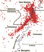
. Three major fault zones lie near Alabama: the New Madrid
, Southern Appalachian, and South Carolina seismic zones. The New Madrid Seismic Zone (NMSZ) is particularly close and has produced large earthquakes, such as those in 1811 and 1812. Because the fault zone is located below densely populated areas such as St. Louis
, a major earthquake from the zone could be catastrophic. The Geological Survey of Alabama predicts a 90 percent chance of an earthquake registering 6.0 or greater in the area by 2040. The shaking from such an earthquake would likely spread into north Alabama. Extending into Alabama, the Southern Appalachian system poses a moderate threat to eastern and central Alabama and is responsible for most of the state's earthquakes. The South Carolina seismic zone has produced earthquakes as powerful as 7.3 on the Richter scale, and a large earthquake originating from it could easily reach Alabama. The 1886 Charleston earthquake, for example, was felt as far as 750 miles (1,207 km) from its epicenter. Another more recently active zone in eastern Tennessee
has produced small earthquakes, including one in Alabama in 1997.
The earthquake originated in the Southern Appalachian Seismic Zone (SASZ), among the most active seismic areas in the Southeastern United States
and one capable of producing moderately strong earthquakes, a few of which have caused damage. The frequency for non-damaging earthquakes from this zone measures out to about one per year, and many earthquakes originating from it that are barely detectable have been recorded on seismographs. Such earthquakes have been helpful in highlighting the activity of faults below the Paleozoic detachment. Fault-plane solutions
of multiple earthquakes throughout the area confirmed strike-slip faulting between two steeply declining planes. Both right and left-lateral movement occurs in the area, most movement being associated with north-to-south planes (right-lateral) and east-to-west planes (left-lateral). All of these mechanisms indicate reactivation of basement faults below more-recent faults. These basement faults probably converge on one another, and one being strong and the other being weak, produce earthquakes.
Near its epicenter, the 1916 Irondale earthquake produced intensities measuring VII and VI on the Mercalli scale. Further away, its intensities ranged from III to IV.
, the earthquake was felt in eight states including Alabama. The epicenter was located in the city of Irondale, roughly 3 miles (5 km) north of Birmingham. Although no fatalities were caused, cracked windows were cracked, and other damage occurred. The most serious damage was in Irondale, where chimneys were toppled. In a two-block area, fourteen chimneys were "partly destroyed". One brick store lost six chimneys as they collapsed from the shaking. Throughout the city, oscillation collapsed many other chimneys or damaged them beyond repair. In various other cities, chimneys lost bricks and light damage occurred. In Birmingham, a few "poorly built" chimneys sustained damage. Other damage reports included extensive damage to wells. Five wells in Irondale were cut off from their underground supplies. Lower water levels were common in the city, and in Pell City, where one well was lowered by as much as 12 inches (30 cm).
In Birmingham people working in office buildings fled when the earthquake occurred. A news article at the time reported: "The sensation on the upper floors of buildings was similar to that of standing on the deck of a vessel in a slight sea. There was the slight pitch, with the suggestion of a roll".
 Twelve counties in Alabama are susceptible to earthquakes. The largest Alabama faces threats from earthquakes within the state, which tend to be moderate, and from those in the NMSZ and other fault zones. State monitoring of earthquake is facilitated by the United States Geological Survey
at the Center for Earthquake Research and Information (CERI) at the University of Memphis
. Birmingham has a seismic station which is part of the Advanced National Seismic System.
Andrew Goodlife, professor of geological sciences at the University of Alabama believes Alabama is at "high" risk from earthquakes. He also claims that "If there is an earthquake in one of the zone areas, North Alabama is certainly going to feel it. There's going to be damage and some perhaps major. If one occurred in the zone close to Memphis, it would be devastating because buildings are not made to withstand earthquakes. Places like San Francisco are aware of earthquake risks and structures are built to withstand them." In his definition, the state's earthquakes are "insignificant". Emergency planner Bill Thomison is skeptical of a major earthquake, stating that "I don't believe there are any major faults (interface of rocks) here. It depends on the magnitude of the earthquake and the Richter scale. You could have a No. 4 (magnitude) earthquake in California and not damage anything, but the same type in New York could be devastating because the building codes don't factor in earthquakes."
The impact of the 1916 earthquake was minor, but should a similarly sized earthquake occur again, damages could be quite extensive. A 2007 USGS study estimates that approximately USD 1 billion in damage might result should relatively powerful earthquake occur in a heavily populated area. The study estimates destruction to as many as 26 buildings, damages to 3,300 structures, and a possible death toll of as many as three people. The study considered factors such as building codes, soil types, and population numbers from the 2000 United States Census.
Alabama
Alabama is a state located in the southeastern region of the United States. It is bordered by Tennessee to the north, Georgia to the east, Florida and the Gulf of Mexico to the south, and Mississippi to the west. Alabama ranks 30th in total land area and ranks second in the size of its inland...
on October 18, 1916. The greatest earthquake
Earthquake
An earthquake is the result of a sudden release of energy in the Earth's crust that creates seismic waves. The seismicity, seismism or seismic activity of an area refers to the frequency, type and size of earthquakes experienced over a period of time...
recorded in state history, it registered an estimated magnitude of 5.1 on the Richter scale and resulted in extensive minor damage, reaching its maximum severity near its epicenter
Epicenter
The epicenter or epicentre is the point on the Earth's surface that is directly above the hypocenter or focus, the point where an earthquake or underground explosion originates...
in the city of Irondale
Irondale, Alabama
Irondale is a city adjacent to Birmingham, Alabama, United States northeast from Homewood and Mountain Brook. At the 2010 census the population was 12,349. The book Fried Green Tomatoes, by Irondale native Fannie Flagg, is loosely based around the town and the landmark Irondale Cafe, known as The...
. Damage from the earthquake, which included cracked windows, fallen chimneys, and the drying of wells, was limited to Shelby
Shelby County, Alabama
Shelby County is a county of the U.S. state of Alabama and a part of the Birmingham–Hoover–Cullman Combined Statistical Area. It is named in honor of Isaac Shelby, Governor of Kentucky. The county seat of Shelby County is Columbiana. As of 2010 U.S. Census the population was 195,085. Shelby...
and Jefferson
Jefferson County, Alabama
Jefferson County is the most populous county in the U.S. state of Alabama, with its county seat being located in Birmingham.As of the 2010 U.S. Census, the population of Jefferson County was 658,466...
counties. Though no one was killed, the earthquake did result in widespread panic, sending alarmed workers from the buildings in which they were working.
The earthquake occurred in the Southern Appalachian Seismic Zone (or Eastern Tennessee Seismic Zone
Eastern Tennessee Seismic Zone
The Eastern Tennessee Seismic Zone is a geographic area subject to frequent small earthquakes which stretches from northeast Alabama to southwest Virginia. The Eastern Tennessee Seismic Zone is also known as the East Tennessee Seismic Zone and the Southern Appalachian Seismic Zone...
), a fault noted for earthquakes of moderate magnitude. Faulting in the area is strike-slip-oriented probably because of the Alabama-New York Lineament, which runs adjacent to the fault. Several scientists believe that the small earthquakes from the zone highlight the reactivation of deep, ancient faults.
Alabama has seen roughly 20 earthquakes since the beginning of the 20th century. In recorded times the earthquakes have been moderate, not reaching above 5.1. Earthquakes tend to cause damage only near their epicenters and shake areas much further away. Major events include those in 1916, 1997, and 2003. Similarly to historic earthquakes, the 1916 event caused extensive damage only near its epicenter but shook areas far away. Despite the lack of powerful earthquakes centered in the state, earthquakes from nearby fault zones—including the New Madrid Seismic Zone
New Madrid Seismic Zone
The New Madrid Seismic Zone , sometimes called the New Madrid Fault Line, is a major seismic zone and a prolific source of intraplate earthquakes in the southern and midwestern United States, stretching to the southwest from New Madrid, Missouri.The New Madrid fault system was responsible for the...
—pose a serious threat to the state's infrastructure. An earthquake similar in size to the 1916 Irondale event today could damage thousands of buildings and cause up to USD $1 billion in damage.
Regional
Unlike the powerful earthquakes along the Pacific Ring of FirePacific Ring of Fire
The Pacific Ring of Fire is an area where large numbers of earthquakes and volcanic eruptions occur in the basin of the Pacific Ocean. In a horseshoe shape, it is associated with a nearly continuous series of oceanic trenches, volcanic arcs, and volcanic belts and/or plate movements...
, seismicity in the central and southern United States (mid-continent) is moderate. The energy from a mid-continent earthquake is distributed over an area as much as ten times that of a similarly-sized earthquake in the western United States. For example, a magnitude 4.0 earthquake west of the Rocky Mountains
Rocky Mountains
The Rocky Mountains are a major mountain range in western North America. The Rocky Mountains stretch more than from the northernmost part of British Columbia, in western Canada, to New Mexico, in the southwestern United States...
can be felt 60 miles (97 km) from its epicenter, but a magnitude 5.5 earthquake in the eastern US can be felt 300 miles (483 km) from its epicenter. Long considered an enigmatic feature of the geology of the United States, this phenomenon presented a mysterious question to scientists. One recent discovery unveiled a decade-old struggle to figure out the facts about an odd formation located in the area. In 1978, geologists discovered a "magnetic" line extending from Alabama to New York. Recent magnetic surveys show that the structure is a 500-million year-old strike-slip fault. The fault starts just under the Eastern Tennessee Seismic Zone, and runs to the eastern coast. If the line is indeed a strike-slip fault, this corresponds with the strike-slip faulting exhibited in the Eastern Tennessee Zone, and would explain mid-continent earthquakes in the United States; however, it is unclear if the fault is definitely related to mid-continental seismicity.
Local
Earthquakes in Alabama are sporadic, and tend to cause little to no damage. There have been approximately 19 earthquakes in the past 91 years, all of varying magnitudes (from nearly imperceptible to damaging). The first known activity in Alabama was the New Madrid earthquakes of 1812, which registered Mercalli scale intensities of VII throughout the northern and central portions of the state. On February 4, 1886, the first known damaging earthquake to originate in the state struck western Alabama, jolting people in Sumter and Marengo counties. One account detailed, "The earthquake happened at daybreak [...] and was preceded by a rumbling noise like the discharge of a heavy cannon in the distance [...] First came the explosion, then the heaving of the earth, the swaying of the trees, the creaking of the trees and the crash of falling things." Later earthquakes took place in the cities of BirminghamBirmingham, Alabama
Birmingham is the largest city in Alabama. The city is the county seat of Jefferson County. According to the 2010 United States Census, Birmingham had a population of 212,237. The Birmingham-Hoover Metropolitan Area, in estimate by the U.S...
in 1957 and Huntsville
Huntsville, Alabama
Huntsville is a city located primarily in Madison County in the central part of the far northern region of the U.S. state of Alabama. Huntsville is the county seat of Madison County. The city extends west into neighboring Limestone County. Huntsville's population was 180,105 as of the 2010 Census....
in 1959. The Birmingham event originated near Guntersville Dam
Guntersville Dam
Guntersville Dam is a hydroelectric dam on the Tennessee River in Marshall County, in the U.S. state of Alabama. It is one of nine dams on the river owned and operated by the Tennessee Valley Authority, which built the dam in the late 1930s as part of a New Deal era initiative to create a...
and extended from northern Alabama to Georgia and Tennessee. Walls were cracked and small objects were knocked off tables. The 1959 event in Huntsville was small, but chimneys were damaged, plaster broken, and objects fell from grocery shelves and tables. Much smaller tremors occurred in 1917, 1927, 1931, and 1939. More recent events occurred in 1997 and 2003 (the Escambia and Fort Payne events, respectively). The Escambia County
Escambia County, Alabama
-2010:Whereas according to the 2010 U.S. Census Bureau:*62.1% White*31.9% Black*4.4% Native American*0.2% Asian*0.0% Native Hawaiian or Pacific Islander*1.5% Two or more races*1.9% Hispanic or Latino -2000:...
event in 1997 measured 4.9 on the Richter scale and released intensities of IV, V, VI, and VII. The Fort Payne earthquake was also a magnitude 4.9 event. Spread over 13 states, the earthquake was deep, preventing it from causing extensive damage in Fort Payne; however, minor cracks and structural issues did result.
Geology
Appalachian Mountains
The Appalachian Mountains #Whether the stressed vowel is or ,#Whether the "ch" is pronounced as a fricative or an affricate , and#Whether the final vowel is the monophthong or the diphthong .), often called the Appalachians, are a system of mountains in eastern North America. The Appalachians...
. Three major fault zones lie near Alabama: the New Madrid
New Madrid Seismic Zone
The New Madrid Seismic Zone , sometimes called the New Madrid Fault Line, is a major seismic zone and a prolific source of intraplate earthquakes in the southern and midwestern United States, stretching to the southwest from New Madrid, Missouri.The New Madrid fault system was responsible for the...
, Southern Appalachian, and South Carolina seismic zones. The New Madrid Seismic Zone (NMSZ) is particularly close and has produced large earthquakes, such as those in 1811 and 1812. Because the fault zone is located below densely populated areas such as St. Louis
St. Louis, Missouri
St. Louis is an independent city on the eastern border of Missouri, United States. With a population of 319,294, it was the 58th-largest U.S. city at the 2010 U.S. Census. The Greater St...
, a major earthquake from the zone could be catastrophic. The Geological Survey of Alabama predicts a 90 percent chance of an earthquake registering 6.0 or greater in the area by 2040. The shaking from such an earthquake would likely spread into north Alabama. Extending into Alabama, the Southern Appalachian system poses a moderate threat to eastern and central Alabama and is responsible for most of the state's earthquakes. The South Carolina seismic zone has produced earthquakes as powerful as 7.3 on the Richter scale, and a large earthquake originating from it could easily reach Alabama. The 1886 Charleston earthquake, for example, was felt as far as 750 miles (1,207 km) from its epicenter. Another more recently active zone in eastern Tennessee
Eastern Tennessee Seismic Zone
The Eastern Tennessee Seismic Zone is a geographic area subject to frequent small earthquakes which stretches from northeast Alabama to southwest Virginia. The Eastern Tennessee Seismic Zone is also known as the East Tennessee Seismic Zone and the Southern Appalachian Seismic Zone...
has produced small earthquakes, including one in Alabama in 1997.
The earthquake originated in the Southern Appalachian Seismic Zone (SASZ), among the most active seismic areas in the Southeastern United States
Southeastern United States
The Southeastern United States, colloquially referred to as the Southeast, is the eastern portion of the Southern United States. It is one of the most populous regions in the United States of America....
and one capable of producing moderately strong earthquakes, a few of which have caused damage. The frequency for non-damaging earthquakes from this zone measures out to about one per year, and many earthquakes originating from it that are barely detectable have been recorded on seismographs. Such earthquakes have been helpful in highlighting the activity of faults below the Paleozoic detachment. Fault-plane solutions
Focal mechanism
The focal mechanism of an earthquake describes the inelastic deformation in the source region that generates the seismic waves. In the case of a fault-related event it refers to the orientation of the fault plane that slipped and the slip vector and is also known as a fault-plane solution...
of multiple earthquakes throughout the area confirmed strike-slip faulting between two steeply declining planes. Both right and left-lateral movement occurs in the area, most movement being associated with north-to-south planes (right-lateral) and east-to-west planes (left-lateral). All of these mechanisms indicate reactivation of basement faults below more-recent faults. These basement faults probably converge on one another, and one being strong and the other being weak, produce earthquakes.
Near its epicenter, the 1916 Irondale earthquake produced intensities measuring VII and VI on the Mercalli scale. Further away, its intensities ranged from III to IV.
Damage
At 5.1 the earthquake's magnitude was the highest ever experienced in the state. Because there were no seismographs, the magnitude is an estimate. Striking just after 4 P.M. local timeEastern Time Zone
The Eastern Time Zone of the United States and Canada is a time zone that falls mostly along the east coast of North America. Its UTC time offset is −5 hrs during standard time and −4 hrs during daylight saving time...
, the earthquake was felt in eight states including Alabama. The epicenter was located in the city of Irondale, roughly 3 miles (5 km) north of Birmingham. Although no fatalities were caused, cracked windows were cracked, and other damage occurred. The most serious damage was in Irondale, where chimneys were toppled. In a two-block area, fourteen chimneys were "partly destroyed". One brick store lost six chimneys as they collapsed from the shaking. Throughout the city, oscillation collapsed many other chimneys or damaged them beyond repair. In various other cities, chimneys lost bricks and light damage occurred. In Birmingham, a few "poorly built" chimneys sustained damage. Other damage reports included extensive damage to wells. Five wells in Irondale were cut off from their underground supplies. Lower water levels were common in the city, and in Pell City, where one well was lowered by as much as 12 inches (30 cm).
In Birmingham people working in office buildings fled when the earthquake occurred. A news article at the time reported: "The sensation on the upper floors of buildings was similar to that of standing on the deck of a vessel in a slight sea. There was the slight pitch, with the suggestion of a roll".
Threat
United States Geological Survey
The United States Geological Survey is a scientific agency of the United States government. The scientists of the USGS study the landscape of the United States, its natural resources, and the natural hazards that threaten it. The organization has four major science disciplines, concerning biology,...
at the Center for Earthquake Research and Information (CERI) at the University of Memphis
University of Memphis
The University of Memphis is an American public research university located in the Normal Station neighborhood of Memphis, Tennessee and is the flagship public research university of the Tennessee Board of Regents system....
. Birmingham has a seismic station which is part of the Advanced National Seismic System.
Andrew Goodlife, professor of geological sciences at the University of Alabama believes Alabama is at "high" risk from earthquakes. He also claims that "If there is an earthquake in one of the zone areas, North Alabama is certainly going to feel it. There's going to be damage and some perhaps major. If one occurred in the zone close to Memphis, it would be devastating because buildings are not made to withstand earthquakes. Places like San Francisco are aware of earthquake risks and structures are built to withstand them." In his definition, the state's earthquakes are "insignificant". Emergency planner Bill Thomison is skeptical of a major earthquake, stating that "I don't believe there are any major faults (interface of rocks) here. It depends on the magnitude of the earthquake and the Richter scale. You could have a No. 4 (magnitude) earthquake in California and not damage anything, but the same type in New York could be devastating because the building codes don't factor in earthquakes."
The impact of the 1916 earthquake was minor, but should a similarly sized earthquake occur again, damages could be quite extensive. A 2007 USGS study estimates that approximately USD 1 billion in damage might result should relatively powerful earthquake occur in a heavily populated area. The study estimates destruction to as many as 26 buildings, damages to 3,300 structures, and a possible death toll of as many as three people. The study considered factors such as building codes, soil types, and population numbers from the 2000 United States Census.