

1891 Mino-Owari earthquake
Encyclopedia
Provinces of Japan
Before the modern prefecture system was established, the land of Japan was divided into tens of kuni , usually known in English as provinces. Each province was divided into gun ....
of Mino
Mino Province
, one of the old provinces of Japan, encompassed part of modern-day Gifu Prefecture. It was sometimes called . Mino Province bordered Echizen, Hida, Ise, Mikawa, Ōmi, Owari, and Shinano Provinces....
and Owari
Owari Province
was an old province of Japan that is now the western half of present day Aichi Prefecture, including much of modern Nagoya. Its abbreviation is Bishū .-History:The province was created in 646....
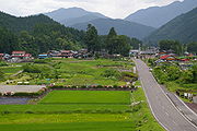
in the Nōbi Plain
Nobi Plain
The is a large plain in Japan that stretches from the Mino area of southwest Gifu Prefecture to the Owari area of northwest Aichi Prefecture, covering an area of approximately . It is an alluvial plain created by the Kiso Three Rivers and has very fertile soil...
area during the Meiji period
Meiji period
The , also known as the Meiji era, is a Japanese era which extended from September 1868 through July 1912. This period represents the first half of the Empire of Japan.- Meiji Restoration and the emperor :...
in Japan. It is also referred to as the Nōbi Earthquake (濃尾地震 Nōbi Jishin) or the Great Nōbi Earthquake (濃尾大地震 Nōbi Daijishin). It is the largest known inland earthquake in Japan.
History
The earthquake struck on October 28, 1891, at 6:38am. Based on the scale of destruction, it has since been estimated to have had a magnitude of 8.0 on the Richter ScaleRichter magnitude scale
The expression Richter magnitude scale refers to a number of ways to assign a single number to quantify the energy contained in an earthquake....
. Its epicenter is believed to have been the Neodani Fault
Neodani Fault
is a left lateral slip fault in Central Japan, Gifu Prefecture, which ruptured causing the 1891 Mino-Owari earthquake in 1891. It caused a 6m vertical offset and 8m left lateral offset, and ruptured over 80 km. The quake was the largest ever recorded in inland Japan.-External Sites:* *...
(35°35’N, 136°20’E), which is located in the present day city of Motosu
Motosu, Gifu
is a city located in the south west of Gifu Prefecture, Japan.As of July 2011, the city has an estimated population of 34,997. The total area is 374.57 km².-History:On October 28, 1891, the Mino-Owari earthquake, the largest earthquake to hit Japan, struck...
, Gifu Prefecture
Gifu Prefecture
is a prefecture located in the Chūbu region of central Japan. Its capital is the city of Gifu.Located in the center of Japan, it has long played an important part as the crossroads of Japan, connecting the east to the west through such routes as the Nakasendō...
. It is believed to be the largest earthquake that has ever occurred whose epicenter is beneath Japanese soil. It is also one of the largest earthquakes in the world's history. When the fault line broke, the height difference between the two sides was approximately six meters.
Damage
Aichi Prefecture
is a prefecture of Japan located in the Chūbu region. The region of Aichi is also known as the Tōkai region. The capital is Nagoya. It is the focus of the Chūkyō Metropolitan Area.- History :...
and Gifu prefectures suffered extensive damage. Damage also occurred in the neighboring Shiga
Shiga Prefecture
is a prefecture of Japan, which forms part of the Kansai region on Honshu Island. The capital is the city of Ōtsu.- History :Shiga was known as Ōmi Province or Gōshū before the prefectural system was established...
and Fukui
Fukui Prefecture
is a prefecture of Japan located in the Chūbu region on Honshū island. The capital is the city of Fukui.- Prehistory :The Kitadani Dinosaur Quarry, on the Sugiyama River within the city limits of Katsuyama, has yielded the Fukuiraptor kitadaniensis and Fukuisaurus tetoriensis as well as an unnamed...
prefectures
Prefectures of Japan
The prefectures of Japan are the country's 47 subnational jurisdictions: one "metropolis" , Tokyo; one "circuit" , Hokkaidō; two urban prefectures , Osaka and Kyoto; and 43 other prefectures . In Japanese, they are commonly referred to as...
. According to records, there were approximately 7,273 deaths and 17,175 casualties, as well as complete destruction of over 140,000 homes. On mountains near the quake's epicenter, all of the trees were knocked down, leaving what is called a "bald mountain." In the city of Gifu
Gifu, Gifu
is a city located in the south-central portion of Gifu Prefecture, Japan, and serves as the prefectural capital. The city has played an important role in Japan's history because of its location in the middle of the country. During the Sengoku period, various warlords, including Oda Nobunaga, used...
and the surrounding areas, fires broke out, causing even more damage. The first newspaper reports described this complete destruction of Gifu by saying that "Gifu has disappeared." Many important structures in Gifu, including Kanō Tenman-gū
Kano Tenman-gu
is a Shinto shrine located in the city of Gifu, Gifu Prefecture, Japan. It was built as the shrine to protect Izumii Castle . As a Tenman-gū, it is dedicated to Tenjin, the deified form of Sugawara no Michizane. Additionally, Matsudaira Mitsushige, who first created Gifu Umbrellas, is also...
and Zenkō-ji
Zenko-ji (Gifu)
is a Buddhist temple of the Shingon sect in Mino Province . It is a branch temple of Daigo-ji in Kyoto, Kyoto Prefecture, Japan. It is also referred to as Gifu Zenkō-ji and Inaba Zenkō-ji...
, were greatly damaged in the resulting fires.
Though the walls of Nagoya Castle
Nagoya Castle
is a Japanese castle located in Nagoya, central Japan. During the Edo period, Nagoya Castle was the center of one of the most important castle towns in Japan—Nagoya-juku— and it included the most important stops along the Minoji, which linked the Tōkaidō with the Nakasendō.-History:In...
and surrounding lodgings from the Edo period
Edo period
The , or , is a division of Japanese history which was ruled by the shoguns of the Tokugawa family, running from 1603 to 1868. The political entity of this period was the Tokugawa shogunate....
were not damaged, modern buildings that were built with Western architectural knowledge subsequently collapsed. The Nagaragawa Iron Bridge and other structures, including brick structures, etc., that were not earthquake-resistant were destroyed. It is because of this earthquake that interest in creating earthquake resistant structures greatly increased.
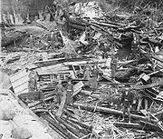
Book memorialising the earthquake
In 1893, seismologist John MilneJohn Milne
For other uses, see John Milne .John Milne was the British geologist and mining engineer who worked on a horizontal seismograph.-Biography:...
and engineer W.K. Burton worked together in co writing and co photographing a book that was published in Yokohama, and recorded the disastrous great Nōbi Earthquake of 1891. The book captured the plight of the Japanese people and the impact of an earthquake on their environment, in dramatic images that were printed by Ogawa Kazumasa
Ogawa Kazumasa
, also known as Ogawa Kazuma or Ogawa Isshin, was a Japanese photographer, printer and publisher who was a pioneer in photomechanical printing and photography in the Meiji era.Ogawa was born in Saitama to the Matsudaira samurai clan...
.
Earthquake preparation and remembrance
