
Yufu, Oita
Encyclopedia
Cities of Japan
||A is a local administrative unit in Japan. Cities are ranked on the same level as and , with the difference that they are not a component of...
located in Ōita Prefecture
Oita Prefecture
is a prefecture of Japan on Kyūshū Island. The prefectural capital is the city of Ōita.- History :Around the 6th century Kyushu consisted of four regions: Tsukushi-no-kuni 筑紫国, Hi-no-kuni 肥国, and Toyo no kuni...
, Japan
Japan
Japan is an island nation in East Asia. Located in the Pacific Ocean, it lies to the east of the Sea of Japan, China, North Korea, South Korea and Russia, stretching from the Sea of Okhotsk in the north to the East China Sea and Taiwan in the south...
.
The city was founded on October 1, 2005 as a result of the merger between the towns of Hasama
Hasama, Oita
was a town located in Ōita District, Ōita, Japan.On October 1, 2005 Hasama was merged with the towns of Shōnai and Yufuin, all from Ōita District, to form the new city of Yufu....
, Shōnai
Shonai, Oita
was a town located in Ōita District, Ōita, Japan.On October 1, 2005 Shōnai was merged with the towns of Hasama and Yufuin, all from Ōita District, to form the city of Yufu....
and Yufuin
Yufuin, Oita
is a district of the city of Yufu, Ōita, Japan.Yufuin was a town located in Ōita District until October 1, 2005, when Yufuin was merged with the towns of Hasama and Shōnai, all from Ōita District, to form the new city of Yufu....
, all from Ōita District
Oita District, Oita
was a district located in Ōita, Japan.As of 2003, the district had an estimated population of 40,723 and density of 99.35 persons per km². The total area was 409.90 km².-Dissolution:As of January 1, 2005 the district had 4 towns.* Hasama* Notsuharu...
.
As of October 1, 2007, the city has an estimated population
Population
A population is all the organisms that both belong to the same group or species and live in the same geographical area. The area that is used to define a sexual population is such that inter-breeding is possible between any pair within the area and more probable than cross-breeding with individuals...
of 35,338 and a density
Population density
Population density is a measurement of population per unit area or unit volume. It is frequently applied to living organisms, and particularly to humans...
of 111 persons per km². The total area is 319.16 km².
Geography
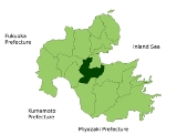
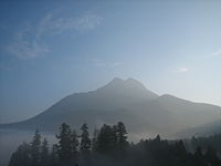
Yufu is located in central Ōita PrefectureOita Prefecture
is a prefecture of Japan on Kyūshū Island. The prefectural capital is the city of Ōita.- History :Around the 6th century Kyushu consisted of four regions: Tsukushi-no-kuni 筑紫国, Hi-no-kuni 肥国, and Toyo no kuni...
, surrounded by highly elevated mountains, such as Yufudake (1583 m), Shirogatake, and Tokiyama . The Ōita River created a alluvial fan
Alluvial fan
An alluvial fan is a fan-shaped deposit formed where a fast flowing stream flattens, slows, and spreads typically at the exit of a canyon onto a flatter plain. A convergence of neighboring alluvial fans into a single apron of deposits against a slope is called a bajada, or compound alluvial...
, where farming is done. Part of the city is named as a portion of Aso Kujū National Park
Aso Kuju National Park
is a national park on the island of Kyūshū in Japan.-See also:*List of national parks of JapanIt is a very popular place for hikers. It has a famous volcano which has a cable car up the crater. It is an active volcano.-External links:...
. Also, Yufu is known for its many hot springs
Hot Springs
Hot Springs may refer to:* Hot Springs, Arkansas** Hot Springs National Park, Arkansas*Hot Springs, California**Hot Springs, Lassen County, California**Hot Springs, Modoc County, California**Hot Springs, Placer County, California...
.
Rivers:Ōita River, Yufu River, Iwaki River
Lakes:Lake Kinrin, Lake Yamashita
Neighboring municipalities
- Ōita PrefectureOita Prefectureis a prefecture of Japan on Kyūshū Island. The prefectural capital is the city of Ōita.- History :Around the 6th century Kyushu consisted of four regions: Tsukushi-no-kuni 筑紫国, Hi-no-kuni 肥国, and Toyo no kuni...
- ŌitaOita, Oitais the capital city of Ōita Prefecture located on the island of Kyushu, Japan.- Demographics and geography :Ōita is the most populous city in Ōita Prefecture...
- BeppuBeppu, Oitais a city located in Ōita Prefecture on the island of Kyushu, Japan, at the west end of Beppu Bay. As of January 1, 2011, the city has an official population of 125,664 and a total area of 125.13 km², with a population density of 977 persons per km²....
- UsaUsa, Oita' is a city located in Ōita Prefecture, Japan. Usa is famous for being the location of the Usa Shrine, built in 725, the head shrine of all of Hachiman shrines in Japan.Usa is made up of three areas.*Usa, the area surrounding the Usa Shrine...
- TaketaTaketa, Oitais a city located in Ōita Prefecture, Japan.As of 2003, the city has an estimated population of 16,807 and a density of 83.69 persons per km². The total area is 200.83 km²....
- KusuKusu, Oitais a town located in Kusu District, Ōita, Japan.As of 2009, the town has an estimated population of 17,945. The total area is 286.44 km².-External links:* *...
- KujūKuju, Oitawas a town located in Naoiri District, Ōita, Japan.On April 1, 2005 Kujū, along with the towns of Naoiri and Ogi, all from Naoiri District, was merged into the expanded city of Taketa....
- Ōita
History
- 1889-Villages Anan, Higashishōnai, Nishishōnai, Minamishōnai, Asono, Tani, Yufugawa, Yunohira, Iwakigawa, and Hasama are created in Ōita DistrictOita District, Oitawas a district located in Ōita, Japan.As of 2003, the district had an estimated population of 40,723 and density of 99.35 persons per km². The total area was 409.90 km².-Dissolution:As of January 1, 2005 the district had 4 towns.* Hasama* Notsuharu...
. Kitayufu, Minamiyufu, and Yunohira are created in Hayami DistrictHayami District, Oita' is a district located in Ōita Prefecture, Japan.As of 2003, the district has an estimated population of 35,462 and the density of 163.46 persons per km². The total area is 216.94 km².-Merger:...
. - 1899-Yunohira village is moved to Ōita District.
- 1936-Minamiyufu and Kitayufu are merged together, creating Yufuin village.
- 1948-Yufuin village is renamed Yufuin town.
- 1950-Yufuin town is moved to Ōita District.
- 1954-Hasama, Tani, Yufugawa, and Iwakigawa is merged together, now named Hasama village. A month later, Anan, Asono, Higashishōnai, Minamishōnai, and Nishishōnai are united. It is named Shōnai village.
- 1955-Yufuin and Yunohira are merged together. The new town is named Yufuin, but the character for "Yu" is different from the one before. In the same year, Shōnai village is renamed Shōnai town and Hasama village is renamed Hasama town.
- 2005-Hasama, Shōnai, and Yufuin are united, the new city named Yufu.