
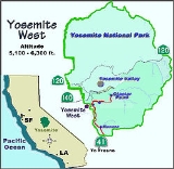
Yosemite West
Overview
Unincorporated area
In law, an unincorporated area is a region of land that is not a part of any municipality.To "incorporate" in this context means to form a municipal corporation, a city, town, or village with its own government. An unincorporated community is usually not subject to or taxed by a municipal government...
private community of resort homes located in the southern area of Yosemite National Park
Yosemite National Park
Yosemite National Park is a United States National Park spanning eastern portions of Tuolumne, Mariposa and Madera counties in east central California, United States. The park covers an area of and reaches across the western slopes of the Sierra Nevada mountain chain...
just off Wawona Road, a continuation of
 State Route 41
California State Route 41
State Route 41 is a state highway in the U.S. state of California, connecting the Cabrillo Highway in Morro Bay with Fresno and Yosemite National Park via the San Joaquin Valley. Except between US 101 in Atascadero and SR 46 near Shandon, SR 41 is part of the California Freeway and Expressway...
from Fresno. It is situated one mile (1.6 km) south of the Chinquapin
Chinquapin, California
Chinquapin is a former settlement in Mariposa County, California. It was located north-northwest of Wawona. Also, it is adjacent to the community of Yosemite West-History:...
intersection of Wawona Road with the Glacier Point Road at an altitude of 5,100–6,300 ft (1,550–1,900 m).
Discussions