
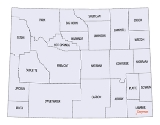
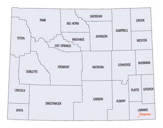
Wyoming census statistical areas
Encyclopedia
The United States Census Bureau
has defined two Metropolitan Statistical Areas (MSAs) and seven Micropolitan Statistical Areas (μSAs) in the State of Wyoming. The following table describes these areas with the following information:
United States Census Bureau
The United States Census Bureau is the government agency that is responsible for the United States Census. It also gathers other national demographic and economic data...
has defined two Metropolitan Statistical Areas (MSAs) and seven Micropolitan Statistical Areas (μSAs) in the State of Wyoming. The following table describes these areas with the following information:
- The name of the Core Based Statistical AreaCore based statistical areaA Core Based Statistical Area is a U.S. geographic area defined by the Office of Management and Budget based around an urban center of at least 10,000 people and adjacent areas that are socioeconomically tied to the urban center by commuting. Areas defined on the basis of these standards applied...
(CBSA). - The population of the CBSA as of July 1, 2006, as estimated by the United States Census Bureau.
- The name of the countyCounty (United States)In the United States, a county is a geographic subdivision of a state , usually assigned some governmental authority. The term "county" is used in 48 of the 50 states; Louisiana is divided into parishes and Alaska into boroughs. Parishes and boroughs are called "county-equivalents" by the U.S...
. - The population of the county as of July 1, 2006, as estimated by the United States Census Bureau.
| Core Based Statistical Area | 2008 Pop | County | 2008 Pop | 2000 Pop | Change |
|---|---|---|---|---|---|
| Cheyenne, WY MSA | 87,542 | Laramie County, Wyoming Laramie County, Wyoming Laramie County is the most populous of the 23 counties of the U.S. state of Wyoming. The county is located in the southeastern corner of the state. The county's population was 91,738 at the 2010 census. The county seat is Cheyenne, the state capital... |
|||
| Casper, WY MSA | 73,129 | Natrona County, Wyoming |
|||
| Gillette, WY μSA | 41,473 | Campbell County, Wyoming |
|||
| Rock Springs, WY μSA | 39,944 | Sweetwater County, Wyoming |
|||
| Riverton, WY μSA | 38,113 | Fremont County, Wyoming |
|||
| Laramie, WY μSA | 32,758 | Albany County, Wyoming |
|||
| Jackson, WY-ID μSA | 29,209 20,376 |
Teton County, Wyoming Teton County, Wyoming Teton County is a county located in the U.S. state of Wyoming. As of 2010, the population was 21,294. Its county seat is Jackson. Teton County contains the affluent Jackson Hole skiing area... |
|||
| Teton County, Idaho Teton County, Idaho Teton County is a county located in the U.S. state of Idaho. Established in 1915, it was named after the Teton Mountains. As of the 2000 Census the county had a population of 5,999... |
|||||
| Sheridan, WY μSA | 28,662 | Sheridan County, Wyoming |
|||
| Evanston, WY μSA | 20,617 | Uinta County, Wyoming Uinta County, Wyoming -Demographics:As of the census of 2000, there were 19,742 people, 6,823 households, and 5,144 families residing in the county. The population density was 10 people per square mile . There were 8,011 housing units at an average density of 4 per square mile... |
|||
| none | Park County, Wyoming |
||||
| Lincoln County, Wyoming |
|||||
| Carbon County, Wyoming Carbon County, Wyoming Carbon County is a county located in the U.S. state of Wyoming. As of 2010, the population was 15,885. Its county seat is Rawlins.- History :Carbon County was organized in 1868.... |
|||||
| Converse County, Wyoming |
|||||
| Goshen County, Wyoming |
|||||
| Big Horn County, Wyoming |
|||||
| Johnson County, Wyoming |
|||||
| Sublette County, Wyoming |
|||||
| Platte County, Wyoming |
|||||
| Washakie County, Wyoming |
|||||
| Weston County, Wyoming |
|||||
| Crook County, Wyoming |
|||||
| Hot Springs County, Wyoming |
|||||
| Niobrara County, Wyoming |
|||||
| State of Wyoming |
|||||
See also
- State of Wyoming
- Demographics of Wyoming
- Geography of Wyoming
- United StatesUnited StatesThe United States of America is a federal constitutional republic comprising fifty states and a federal district...
- United States Census BureauUnited States Census BureauThe United States Census Bureau is the government agency that is responsible for the United States Census. It also gathers other national demographic and economic data...
- Table of United States Combined Statistical AreasTable of United States Combined Statistical Areasthumb|An enlargeable map of the 125 [[Combined Statistical Area]]s of the [[United States]]The United States Office of Management and Budget has defined 125 Combined Statistical Areas for the United States of America...
(CSA) - Table of United States Core Based Statistical Areas (CBSA)
- Table of United States Metropolitan Statistical AreasTable of United States Metropolitan Statistical Areasthumb|An enlargeable map of the 942 [[Core Based Statistical Area]]s of the [[United States]]. The 367 [[Metropolitan Statistical Area]]s are shown in red....
(MSA) - Table of United States Micropolitan Statistical AreasTable of United States Micropolitan Statistical Areasthumb|An enlargeable map of the 942 [[Core Based Statistical Area]]s of the [[United States]]. The 576 [[Micropolitan Statistical Area]]s are shown in blue....
(μSA) - Table of United States primary census statistical areas (PCSA)
- Table of United States Combined Statistical Areas
- United States Census Bureau