

Wyoming Highway 110
Encyclopedia
State highway
State highway, state road or state route can refer to one of three related concepts, two of them related to a state or provincial government in a country that is divided into states or provinces :#A...
in western-central Crook County, Wyoming that runs from Wyoming Highway 24
Wyoming Highway 24
Wyoming Highway 24 is a State highway in Wyoming. Spanning from US 14 to the Wyoming-South Dakota state line as SD 34, it passes by Devils Tower National Monument.- Route description :...
to the Devils Tower National Monument
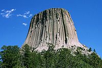
Devils Tower National Monument
Devils Tower is an igneous intrusion or laccolith located in the Black Hills near Hulett and Sundance in Crook County, northeastern Wyoming, above the Belle Fourche River...
.
Route description
Wyoming Highway 110 is a short 0.59 mile (0.9495106 km) roadway that starts its east end at Wyoming Highway 24Wyoming Highway 24
Wyoming Highway 24 is a State highway in Wyoming. Spanning from US 14 to the Wyoming-South Dakota state line as SD 34, it passes by Devils Tower National Monument.- Route description :...
and travels west to the Devils Tower National Monument
Devils Tower National Monument
Devils Tower is an igneous intrusion or laccolith located in the Black Hills near Hulett and Sundance in Crook County, northeastern Wyoming, above the Belle Fourche River...
Entrance. Mileposts along WYO 110 increase east to west.