
Wurzbach Parkway
Encyclopedia
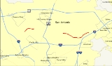
Wurzbach Parkway is a part freeway and part major arterial road
in San Antonio, Texas
built to provide relief on Interstate 410 and Loop 1604 on the city's northside. The highway is named for Harry M. Wurzbach
, who represented the San Antonio area in Congress as a Republican in the 1920s and 30s. The Congressman's name was first applied to the connecting Wurzbach Road. The highway is in different stages of completion with the eastern third built as a freeway and the western section as an expressway
with at-grade intersections. Currently there is a gap in the highway, but there are plans to connect the two segments with an interchange with U.S. Highway 281. The highway, along with part of Wurzbach Road near the Ingram Park Mall
, is maintained by the Texas Department of Transportation
despite not carrying a state highway designation. Rather, it is being developed and maintained under the Principal Arterial Street System (PASS) program. The parkway does not connect to any other freeways, but drivers can access I-10, US 281, and I-35 via local roads that extend the parkway.
), crossing Military Highway (FM 1535
) at-grade. Wurzbach Road continues southwest from Lockhill-Selma Road, crossing I-10 at exit 561. To the east, a second section, built as a freeway, begins at Starcrest Drive (which continues northwest towards US 281) and Wetmore Road, on the northeast side of the San Antonio International Airport
, and heads east beyond Thousand Oaks Drive. At the east end are several at-grade intersections before the parkway ends at O'Connor Road and Crosswinds Way; O'Connor Road leads southeast to I-35 at exit 169.
, emphasizing the segment that has not been constructed. The EA will supplement the EA completed several years ago prior to initial construction. The Alamo RMA is currently considering three alternatives for the interchange with US 281. The first alternative is a Wurzbach Parkway bridge over US 281 with no direct connection between the two highways, but with access via the two highway's frontage road
s. The second option includes an elevated roundabout interchange
, that will provide direct access between the highways. The final alternative involves main lane to main lane connector ramps from Wurzbach Parkway to US 281 and loop ramps for access from US 281 to Wurzbach Parkway.
According to the San Antonio Express-News
, the Texas Transportation Commission reviewed the parkway expansion on Thursday November 19, 2009. The project is proposed to be funded by proceeds from Proposition 12 bonds approved by voters in 2007, a package which will be voted on by commissioners in November. Clay Smith, TxDOT's San Antonio District planning engineer, said the Wurzbach Parkway project would get $126 million under the bond-financing plan, enough for TxDOT to finish the three final segments left on the parkway. The expansion construction will be completed in two phases: the first from Blanco Road to West Avenue and from Jones Maltsberger Road to Wetmore; the second between West Avenue and Jones Maltsberger.
Arterial road
An arterial road, or arterial thoroughfare, is a high-capacity urban road. The primary function of an arterial road is to deliver traffic from collector roads to freeways, and between urban centres at the highest level of service possible. As such, many arteries are limited-access roads, or feature...
in San Antonio, Texas
San Antonio, Texas
San Antonio is the seventh-largest city in the United States of America and the second-largest city within the state of Texas, with a population of 1.33 million. Located in the American Southwest and the south–central part of Texas, the city serves as the seat of Bexar County. In 2011,...
built to provide relief on Interstate 410 and Loop 1604 on the city's northside. The highway is named for Harry M. Wurzbach
Harry M. Wurzbach
Harry McLeary Wurzbach was the first Republican since Reconstruction to represent Texas for more than two terms in the U.S. House of Representatives. Rep. Robert B. Hawley had previously served as a Republican for a Galveston based congressional district from 1897-1901...
, who represented the San Antonio area in Congress as a Republican in the 1920s and 30s. The Congressman's name was first applied to the connecting Wurzbach Road. The highway is in different stages of completion with the eastern third built as a freeway and the western section as an expressway
Limited-access road
A limited-access road known by various terms worldwide, including limited-access highway, dual-carriageway and expressway, is a highway or arterial road for high-speed traffic which has many or most characteristics of a controlled-access highway , including limited or no access to adjacent...
with at-grade intersections. Currently there is a gap in the highway, but there are plans to connect the two segments with an interchange with U.S. Highway 281. The highway, along with part of Wurzbach Road near the Ingram Park Mall
Ingram Park Mall
Ingram Park Mall is a super regional shopping center located in the northwest section of San Antonio, Texas at the intersection of Interstate 410 and Ingram Road.-Anchors:*Dillard's...
, is maintained by the Texas Department of Transportation
Texas Department of Transportation
The Texas Department of Transportation is a governmental agency in the U.S. state of Texas. Its stated mission is to "work cooperatively to provide safe, effective and efficient movement of people and goods" throughout the state...
despite not carrying a state highway designation. Rather, it is being developed and maintained under the Principal Arterial Street System (PASS) program. The parkway does not connect to any other freeways, but drivers can access I-10, US 281, and I-35 via local roads that extend the parkway.
Route description
The west portion of the parkway is a limited-access surface road that connects Lockhill-Selma Road with Blanco Road (FM 2696Farm to Market Road 2696
Farm to Market Road 2696 is a farm to market road in Bexar County, Texas. It is known in Greater San Antonio as Blanco Road, a major north–south thoroughfare.-Route description:...
), crossing Military Highway (FM 1535
Farm to Market Road 1535
Farm to Market Road 1535 is a farm to market road in Bexar County, Texas. It is known in Greater San Antonio as NW Military Highway.-Route description:...
) at-grade. Wurzbach Road continues southwest from Lockhill-Selma Road, crossing I-10 at exit 561. To the east, a second section, built as a freeway, begins at Starcrest Drive (which continues northwest towards US 281) and Wetmore Road, on the northeast side of the San Antonio International Airport
San Antonio International Airport
San Antonio International Airport is a commercial airport in San Antonio, Texas, USA. The airport has three runways and covers . Its elevation is above sea level. SAT is a Class C airport.- Overview :...
, and heads east beyond Thousand Oaks Drive. At the east end are several at-grade intersections before the parkway ends at O'Connor Road and Crosswinds Way; O'Connor Road leads southeast to I-35 at exit 169.
History
Planners conceived the parkway in the mid-1980s as the east–west Parkway, an extension of the existing Wurzbach Road, to relieve traffic on I-410. The road, estimated to cost $90 million, was approved by the Texas Transportation Commission in 1988, to be built by the state but funded in part by the city. Construction began in mid-1994 on the section between Wetmore Road and Nacogdoches Road, and the eastern portion of the roadway opened on August 26, 1999, allowing traffic to bypass I-410. The west section was opened on July 24, 2002, but work has yet to be completed on the connection between these two portions.Future
The Alamo Regional Mobility Authority (RMA) is currently conducting a supplemental environmental assessment on the entire corridor from Lockhill-Selma Road to I-35Interstate 35 in Texas
Interstate 35 in Texas is a major north–south Interstate Highway running from Laredo near the United States-Mexico border to the Red River north of Gainesville where it crosses into Oklahoma. Along its route, it passes through the cities of San Antonio, Austin, and Waco before it splits into two...
, emphasizing the segment that has not been constructed. The EA will supplement the EA completed several years ago prior to initial construction. The Alamo RMA is currently considering three alternatives for the interchange with US 281. The first alternative is a Wurzbach Parkway bridge over US 281 with no direct connection between the two highways, but with access via the two highway's frontage road
Frontage road
A frontage road is a non-limited access road running parallel to a higher-speed road, usually a freeway, and feeding it at appropriate points of access...
s. The second option includes an elevated roundabout interchange
Roundabout interchange
A roundabout interchange is a type of interchange between a controlled access highway such as a motorway or freeway, and a minor road, in which the slip roads to and from the motorway carriageways converge at a single roundabout, which is grade-separated from the motorway lanes with bridges...
, that will provide direct access between the highways. The final alternative involves main lane to main lane connector ramps from Wurzbach Parkway to US 281 and loop ramps for access from US 281 to Wurzbach Parkway.
According to the San Antonio Express-News
San Antonio Express-News
The San Antonio Express-News is the daily newspaper of San Antonio, Texas. It is ranked as the third-largest daily newspaper in the state of Texas in terms of circulation, and is one of the leading news sources of South Texas, with offices in Austin, Brownsville, Laredo, and Mexico City...
, the Texas Transportation Commission reviewed the parkway expansion on Thursday November 19, 2009. The project is proposed to be funded by proceeds from Proposition 12 bonds approved by voters in 2007, a package which will be voted on by commissioners in November. Clay Smith, TxDOT's San Antonio District planning engineer, said the Wurzbach Parkway project would get $126 million under the bond-financing plan, enough for TxDOT to finish the three final segments left on the parkway. The expansion construction will be completed in two phases: the first from Blanco Road to West Avenue and from Jones Maltsberger Road to Wetmore; the second between West Avenue and Jones Maltsberger.
Exit list
| County | Location | Mile | Destinations | Notes |
|---|---|---|---|---|
| Bexar Bexar County, Texas As of the census of 2000, there were 1,392,931 people, 488,942 households, and 345,681 families residing in the county. The population density was 1,117 people per square mile . There were 521,359 housing units at an average density of 418 per square mile... |
San Antonio San Antonio, Texas San Antonio is the seventh-largest city in the United States of America and the second-largest city within the state of Texas, with a population of 1.33 million. Located in the American Southwest and the south–central part of Texas, the city serves as the seat of Bexar County. In 2011,... |
Starcrest Drive | Westbound only | |
| Wetmore Road | ||||
| Nacogdoches Road | ||||
| Thousand Oaks Drive | ||||
| Turnaround | Eastbound only | |||
| Weidner Road | At-grade junction | |||
| O'Connor Road, Crosswinds Way | At-grade junction |