

Woronora, New South Wales
Encyclopedia
Woronora is a suburb
in southern
Sydney
, in the state of New South Wales
, Australia
. Woronora is located 27 kilometres south of the Sydney central business district
, in the local government area of the Sutherland Shire
. Woronora Heights
is a separate suburb, to the south-west.
placename. Records show the spelling of the name has varied since it first appeared in the 19th century, the earliest being Wooloonora (Dixon, 1827, quoted in Walker 1974:66), followed by Wolonora (Dixon, 1837), and Woronora (Mitchell, 1835). The name was first applied to the Woronora River, a tributary of the Georges River
, before being given to a hundred, an electoral district, a local road east of the river, and finally the suburb itself.
The following meanings have been suggested for Woronora:
Variations such as 'black cliffs' and 'sharkless waters' have also been suggested by local residents.
The Aboriginal language known variously as Dharug, Eora or simply 'the Sydney Language' was spoken around Woronora at the time of colonisation (Troy 1994:61). Lists of Dharug words gathered around the turn of the century provide a number of possibilities regarding the number of morphemes
and likely constituents of the placename. An analysis of the number of syllables in Dharug words recorded by Mathews (1901) shows over 50% contained two syllables, and just under 40% contained three, while only 1.45% contained one syllable:
It therefore seems likely that Woronora is made up of two disyllabic elements.
In light of what historical Dharug information is available, the meaning of the suffix of Woronora seems most transparent. A range of phonetically similar words are present in the sources:
We may tentatively conclude therefore that *-ngurra could function as a locative
suffix in Dharug.
The stem of Woronora is much harder to specify. Unfortunately, no word list contains a word *wooloo, *wolo, or *woro, but the following orthographically similar words are present:
Oft-cited definitions like 'black rocks' find no support in the written records. Words for 'black', 'shark' and 'water' do not resemble any element of Woronora, though we lack a record for the Dharug words for 'rock', 'cliff', 'river', and 'creek', and thus cannot categorically rule these out.
Guesses regarding the original form of the placename depend largely upon the degree of mishearing assumed to have taken place between the Aboriginal informant and the European recorder. Might a surveyor have missed a syllable in *wolaru-ngurra? Although English speakers frequently reproduced trilled rhotics as either /r/ or /l/ orthographically (Donaldson 2002:235), it is difficult to establish whether the name was misheard from Aboriginal sources three times (producing the Wooloo-, Wolo-, and Woro- variants), or whether the change in spelling was a product of changing European pronunciation without reference to Aboriginal people. The latter is quite likely considering that until the 1840s, and possibly beyond, it was the only official placename from the mouth of the river southwards (Dixon 1841), and thus must have been written and pronounced frequently in reference to a large area.
Assuming therefore that the original placename most closely resembled Wooloonora, and acknowledging the inadequacy of our records due to language loss, three potential definitions present themselves:
Cultural information could be the deciding factor in defining Woronora. Was there a Rain or Wallaroo Dreaming
in this part of Sydney? Could reported dialogue of the Dreamtime ancestors make sense of 'then place'? Or was there another noun unknown to us relating to black rock/s? Unfortunately the consequences of colonisation for the Dharug people in terms of land loss, dispersal and language loss mean this will probably never be known.
 The suburb is completely ringed by bushland, with only a single road providing access. Many think that this adds to the charm of the suburb which has curiously escaped the development that its surrounding suburbs have experienced. They feel that this has contributed to the sense of community in Woronora.
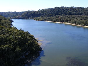
The Woronora River is tidal at this point. River levels and water quality at Woronora can be affected by the release of water from the Woronora Dam upstream upstream from the suburb.
Woronora Plateau, is a geographical region adjacent to the Sydney Plain. Slightly higher in altitude, it is capped with Hawkesbury Sandstone. The Woronora River
flows through the deeply dissected plateau to the Georges River
from near the sources of the Port Hacking
, within the Sutherland Shire.
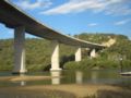 The Woronora Bridge
, was built to eliminate the steep decents and ascents for traffic between Sutherland
and Menai
. The bridge is approximately 600 metres long and was completed in 2001 as an alternative to the Old Woronora Bridge. There is a public path located just underneath the road on the bridge shared between bicycle and pedestrians. The path can be accessed from Menai Road on the Bangor side and Prince Edward Park Road or River Road on the Sutherland side.
that is closed to all vehicles. It is accessible to pedestrians, cyclists and for emergency access. It has remained closed due to protests from those who live in Woronora and parts of Woronora Heights concerned that if the fire trail was opened to general transport, it would create an influx of vehicles from Engadine
using Woronora as a 'shortcut' to Menai
and Sutherland
. They feel it would congest and change the character of the small suburb. In 2006, Frank Sartor, a member for the NSW State Government intervened and zoned the fire trail such that it would not be able to be used for public or general transport. Up until this decision, many houses through the area displayed placards protesting against members of the local Sutherland Shire Council that were pushing to have the road opened to public transport, and others that sought to see the road opened to general traffic.
Club, boatshed, rugby league
football oval (which is also a cricket ground in summer), caravan park, primary school which opened in 1942, cafe, restaurant (riverside), a fire station, hairdresser, bottle shop, general store and a cemetery (close to Sutherland
). It is also home to the only floating fire station in Australia to provide for residents which do not have road access.
Suburb
The word suburb mostly refers to a residential area, either existing as part of a city or as a separate residential community within commuting distance of a city . Some suburbs have a degree of administrative autonomy, and most have lower population density than inner city neighborhoods...
in southern
Southern Sydney
This article refers to an area the same as a combination of St George and SutherlandSouthern Sydney is a general term which is used to describe the southern metropolitan area of Sydney, in the state of New South Wales, Australia....
Sydney
Sydney
Sydney is the most populous city in Australia and the state capital of New South Wales. Sydney is located on Australia's south-east coast of the Tasman Sea. As of June 2010, the greater metropolitan area had an approximate population of 4.6 million people...
, in the state of New South Wales
New South Wales
New South Wales is a state of :Australia, located in the east of the country. It is bordered by Queensland, Victoria and South Australia to the north, south and west respectively. To the east, the state is bordered by the Tasman Sea, which forms part of the Pacific Ocean. New South Wales...
, Australia
Australia
Australia , officially the Commonwealth of Australia, is a country in the Southern Hemisphere comprising the mainland of the Australian continent, the island of Tasmania, and numerous smaller islands in the Indian and Pacific Oceans. It is the world's sixth-largest country by total area...
. Woronora is located 27 kilometres south of the Sydney central business district
Sydney central business district
The Sydney central business district is the main commercial centre of Sydney, New South Wales, Australia. It extends southwards for about 3 kilometres from Sydney Cove, the point of first European settlement. Its north–south axis runs from Circular Quay in the north to Central railway station in...
, in the local government area of the Sutherland Shire
Sutherland Shire
The Sutherland Shire is a Local Government Area in the Southern Sydney region of Sydney, Australia. Geographically, it is the area to the south of Botany Bay and the Georges River...
. Woronora Heights
Woronora Heights, New South Wales
Woronora Heights is a suburb in southern Sydney, in the state of New South Wales, Australia. Woronora Heights is located 29 kilometres south of the Sydney central business district, in the local government area of the Sutherland Shire. Woronora is a separate suburb, to the north...
is a separate suburb, to the south-west.
Placename History
'Woronora' is an AboriginalIndigenous Australians
Indigenous Australians are the original inhabitants of the Australian continent and nearby islands. The Aboriginal Indigenous Australians migrated from the Indian continent around 75,000 to 100,000 years ago....
placename. Records show the spelling of the name has varied since it first appeared in the 19th century, the earliest being Wooloonora (Dixon, 1827, quoted in Walker 1974:66), followed by Wolonora (Dixon, 1837), and Woronora (Mitchell, 1835). The name was first applied to the Woronora River, a tributary of the Georges River
Georges River
The Georges River is a waterway in the state of New South Wales in Australia. It rises to the south-west of Sydney near the coal mining town of Appin, and then flows north past Campbelltown, roughly parallel to the Main South Railway...
, before being given to a hundred, an electoral district, a local road east of the river, and finally the suburb itself.
The following meanings have been suggested for Woronora:
- 'black rock' (Appleton and Appleton 1992)
- 'black rocks' (Walker 1974; Neve 1970)
- 'river-of-no-sharks' (Bolton 2000)
Variations such as 'black cliffs' and 'sharkless waters' have also been suggested by local residents.
The Aboriginal language known variously as Dharug, Eora or simply 'the Sydney Language' was spoken around Woronora at the time of colonisation (Troy 1994:61). Lists of Dharug words gathered around the turn of the century provide a number of possibilities regarding the number of morphemes
Morpheme
In linguistics, a morpheme is the smallest semantically meaningful unit in a language. The field of study dedicated to morphemes is called morphology. A morpheme is not identical to a word, and the principal difference between the two is that a morpheme may or may not stand alone, whereas a word,...
and likely constituents of the placename. An analysis of the number of syllables in Dharug words recorded by Mathews (1901) shows over 50% contained two syllables, and just under 40% contained three, while only 1.45% contained one syllable:
| syllables | 1 | 2 | 3 | 4 | 5 | TOTAL |
| no. words | 4 | 139 | 109 | 23 | 1 | 276 |
| % of total | 1.45% | 50.37% | 39.49% | 8.33% | 0.36% | 100% |
It therefore seems likely that Woronora is made up of two disyllabic elements.
In light of what historical Dharug information is available, the meaning of the suffix of Woronora seems most transparent. A range of phonetically similar words are present in the sources:
- ngurra 'camp' (Troy 1994:67; Stockton 1993:156; Mathews 1901:158)
- nura 'place or country' (Troy 1993:83)
- ngurang 'place' (Troy 1993:78)
- ora 'a place or country e.g. Woronora' (Kohen 1993:16)
- 'place; gno-rang, no-rar (Kohen 1990:238)
We may tentatively conclude therefore that *-ngurra could function as a locative
Locative case
Locative is a grammatical case which indicates a location. It corresponds vaguely to the English prepositions "in", "on", "at", and "by"...
suffix in Dharug.
The stem of Woronora is much harder to specify. Unfortunately, no word list contains a word *wooloo, *wolo, or *woro, but the following orthographically similar words are present:
- wal-lan 'rain' (Ridley 1875:105; Kohen 1993:224), wulan 'rain' (Troy 1993:71)
- wolora 'wallaroo' (Mathews 1901:158), wularu 'wallaroo' (Troy 1993:52), wolaru 'kangaroo (mountain)' (Ridley 1875:104)
- wurral 'slow' (Mathews 1901:159)
- warra 'breast' (Troy 1993:34)
- wural 'bashful, ashamed' (Troy 1993:66)
- wala 'then' (Troy 1993:79)
- wurra 'mouse, rat' (Troy 1994:69)
Oft-cited definitions like 'black rocks' find no support in the written records. Words for 'black', 'shark' and 'water' do not resemble any element of Woronora, though we lack a record for the Dharug words for 'rock', 'cliff', 'river', and 'creek', and thus cannot categorically rule these out.
Guesses regarding the original form of the placename depend largely upon the degree of mishearing assumed to have taken place between the Aboriginal informant and the European recorder. Might a surveyor have missed a syllable in *wolaru-ngurra? Although English speakers frequently reproduced trilled rhotics as either /r/ or /l/ orthographically (Donaldson 2002:235), it is difficult to establish whether the name was misheard from Aboriginal sources three times (producing the Wooloo-, Wolo-, and Woro- variants), or whether the change in spelling was a product of changing European pronunciation without reference to Aboriginal people. The latter is quite likely considering that until the 1840s, and possibly beyond, it was the only official placename from the mouth of the river southwards (Dixon 1841), and thus must have been written and pronounced frequently in reference to a large area.
Assuming therefore that the original placename most closely resembled Wooloonora, and acknowledging the inadequacy of our records due to language loss, three potential definitions present themselves:
- *wulan-ngurra 'rain place'
- *wolaru-ngurra 'wallaroo place'
- *wala-ngurra 'then place'
Cultural information could be the deciding factor in defining Woronora. Was there a Rain or Wallaroo Dreaming
Dreaming (spirituality)
The Dreaming is a common term within the animist creation narrative of indigenous Australians for a personal, or group, creation and for what may be understood as the "timeless time" of formative creation and perpetual creating....
in this part of Sydney? Could reported dialogue of the Dreamtime ancestors make sense of 'then place'? Or was there another noun unknown to us relating to black rock/s? Unfortunately the consequences of colonisation for the Dharug people in terms of land loss, dispersal and language loss mean this will probably never be known.
Geography
The residential area of Woronora lines both sides of the Woronora River. The Woronora bridge is northern limit to residential housing. A footbridge crosses the river at the southernmost limit of housing on the western bank. The housing on the eastern bank continues beyond the end of Prince Edward Park Rd, and some houses can only be reached by a walking track or by boat.The Woronora River is tidal at this point. River levels and water quality at Woronora can be affected by the release of water from the Woronora Dam upstream upstream from the suburb.
Woronora Plateau, is a geographical region adjacent to the Sydney Plain. Slightly higher in altitude, it is capped with Hawkesbury Sandstone. The Woronora River
Woronora River
The Woronora River flows north from near Helensburgh into the Georges River between Como and Illawong.- Crossings :The river is crossed by high level and low level road bridges and a footbridge in Woronora, New South Wales...
flows through the deeply dissected plateau to the Georges River
Georges River
The Georges River is a waterway in the state of New South Wales in Australia. It rises to the south-west of Sydney near the coal mining town of Appin, and then flows north past Campbelltown, roughly parallel to the Main South Railway...
from near the sources of the Port Hacking
Port Hacking
Port Hacking is an Australian estuary, located in Southern Sydney, New South Wales and fed by the Hacking River and several smaller creeks, including Bundeena Creek and The Basin. It is a ria, a river basin which has become submerged by the sea...
, within the Sutherland Shire.
Transport
Woronora River Bridge
The Woronora River Bridge is a road bridge over the Woronora River at Woronora, Sydney, New South Wales, Australia...
, was built to eliminate the steep decents and ascents for traffic between Sutherland
Sutherland, New South Wales
Sutherland is a suburb in southern Sydney, in the state of New South Wales, Australia. Sutherland is located 26 kilometres south of the Sydney central business district and is the administrative centre for the local government area of the Sutherland Shire....
and Menai
Menai, New South Wales
Menai is a suburb in southern Sydney, in the state of New South Wales, Australia. Menai is located 29 kilometres south of the Sydney central business district in the local government area of the Sutherland Shire.-History:...
. The bridge is approximately 600 metres long and was completed in 2001 as an alternative to the Old Woronora Bridge. There is a public path located just underneath the road on the bridge shared between bicycle and pedestrians. The path can be accessed from Menai Road on the Bangor side and Prince Edward Park Road or River Road on the Sutherland side.
Woronora Fire Trail
There is a fire trail between Woronora and Woronora HeightsWoronora Heights, New South Wales
Woronora Heights is a suburb in southern Sydney, in the state of New South Wales, Australia. Woronora Heights is located 29 kilometres south of the Sydney central business district, in the local government area of the Sutherland Shire. Woronora is a separate suburb, to the north...
that is closed to all vehicles. It is accessible to pedestrians, cyclists and for emergency access. It has remained closed due to protests from those who live in Woronora and parts of Woronora Heights concerned that if the fire trail was opened to general transport, it would create an influx of vehicles from Engadine
Engadine, New South Wales
Engadine is a suburb in southern Sydney, in the state of New South Wales, Australia. Engadine is located south of the Sydney central business district, in the local government area of the Sutherland Shire...
using Woronora as a 'shortcut' to Menai
Menai, New South Wales
Menai is a suburb in southern Sydney, in the state of New South Wales, Australia. Menai is located 29 kilometres south of the Sydney central business district in the local government area of the Sutherland Shire.-History:...
and Sutherland
Sutherland, New South Wales
Sutherland is a suburb in southern Sydney, in the state of New South Wales, Australia. Sutherland is located 26 kilometres south of the Sydney central business district and is the administrative centre for the local government area of the Sutherland Shire....
. They feel it would congest and change the character of the small suburb. In 2006, Frank Sartor, a member for the NSW State Government intervened and zoned the fire trail such that it would not be able to be used for public or general transport. Up until this decision, many houses through the area displayed placards protesting against members of the local Sutherland Shire Council that were pushing to have the road opened to public transport, and others that sought to see the road opened to general traffic.
Landmarks
Woronora features an RSLReturned and Services League of Australia
The Returned and Services League of Australia is a support organisation for men and women who have served or are serving in the Australian Defence Force ....
Club, boatshed, rugby league
Rugby league
Rugby league football, usually called rugby league, is a full contact sport played by two teams of thirteen players on a rectangular grass field. One of the two codes of rugby football, it originated in England in 1895 by a split from Rugby Football Union over paying players...
football oval (which is also a cricket ground in summer), caravan park, primary school which opened in 1942, cafe, restaurant (riverside), a fire station, hairdresser, bottle shop, general store and a cemetery (close to Sutherland
Sutherland, New South Wales
Sutherland is a suburb in southern Sydney, in the state of New South Wales, Australia. Sutherland is located 26 kilometres south of the Sydney central business district and is the administrative centre for the local government area of the Sutherland Shire....
). It is also home to the only floating fire station in Australia to provide for residents which do not have road access.