
Wollombi, New South Wales
Encyclopedia
Wollombi is a small village in the Hunter Region of New South Wales
, Australia
. It is within the Cessnock City Council
LGA, situated 29 kilometres (18 mi) southwest of Cessnock
and 128 km (80 mi) north of Sydney
. To the south is the village of Laguna, to the east, the village of Millfield and to the north, the village of Broke
.
The valley is bordered to the west by the World Heritage
listed Yengo National Park
(and Yengo State Forest) and the main road, the convict
-built Great North Road (GNR) forms one of the major legs of the Greater Blue Mountains
Drive. To the east lie Watagans National Park
along with Corrabare and Olney State Forests.
Wollombi's modest modern size is offset by its 19th century sandstone buildings and timber slab constructed cottages and sheds in a narrow valley junction containing Wollombi Brook and Congewai Creek. Narone and Yango Creeks also join these waterways near the village.
The area is home to an abundance of native birds, reptiles and other animals including kangaroo
s, wallabies
, wallaroo
s and wombat
s and is surrounded by imposing tree-lined mountains.
, though the Awabakal
and Wanaruah nations are also mentioned.
The town's name is an Aboriginal
term said to mean 'meeting place of the waters' or simply 'meeting place' ("Derived from Awabakal Aboriginal term for 'meeting of waters', but this cannot be linguistically verified. (Appleton; 1992). Also: meeting of the waters. (McCarthy; 1963)."). It was apparently pronounced 'Wu-lum-bee', though today it is pronounced Wo (as in wok) - lum (as in thumb) - bi (as in buy).
There are a vast number of historic Aboriginal sites in the surrounding countryside which is thought to have been used as a ceremonial meeting place as people from hundreds of kilometres visited the area and made their way to Mount Yengo
- a place of great significance throughout the ancient nations of eastern Australia.
There are rock engravings, sharpening grooves, hand stencils, tribal markings and other images in caves and outcrops, frequent evidence of camping sites along the Brook and its tributary creeks, and two major mapping sites containing many engravings.
The establishment, development and significance of the township of Wollombi was directly connected with the construction and importance of the Great Northern Road in the early 19th century. The Howes Valley Rd (Putty Road
) was completed in 1823, but travel along it was thought to be too difficult to be a success commercially.
Major Thomas Mitchell - Surveyor-General - formulated the idea of an inland route to open up transport to regions in northern NSW. Heneage Finch, who later settled in Laguna, surveyed the route for the Great Northern Road via Castle Hill
, Wisemans Ferry
, St Albans
, Laguna and Wollombi.
At Wollombi, the road diverged toward Singleton and Muswellbrook
to the north, and Cessnock and Maitland
to the north east.
Hundreds of convict
s began building the road from Castle Hill to Wollombi. One group was headquartered at Castle Hill where over 380 men were organised in seven road parties. They began work on the section of road south of the Hawkesbury. A second group, of 119 men, worked from Newcastle in two road parties, one between Newcastle and Wallis Plains (Maitland) and the other between Wallis Plains and Wollombi.
Road construction commenced in 1826 and was completed in 1831. Remnants such as stone culverts, bridges and retaining walls remain, particularly in the area between Wisemans Ferry and Wollombi, and are catalogued and cared for by the The Convict Trail Project.
During the years before the GNR was commenced, only a few large land grants (1000–2000 acre (404.7–809.4 ha)) were allocated along Cockfighter's Creek or the lower Wollombi Brook, to John Blaxland
and - Rodd at Fordwich, Heneage Finch at Laguna and Thomas Crawford at Congewai. Richard Wiseman received 640 acre (259 ha) near Wollombi. After 1830 the holdings in the Wollombi Valley were about 100 acre (40 ha).
Surveyor GB White surveyed the village reserve at Wollombi into sections and allotments in 1833.
A horseman who travelled from Sydney to Patrick's Plains in 1827 along the line of road in progress took three days for the journey – the first day to Wiseman's Ferry - 49 miles (79 km). The second day to 'the head of the Wollombi' (about 12 mi (19 km) south of the future Wollombi village reserve) - 40 mi (64 km), and the third day to Patrick's Plains - 36 mi (58 km), made a total of 125 mi (201 km).
The settlement developed as a centre for the farming community and for travellers on the Great North Road. Then, on 12 June 1831, the steamship 'Sophie Jane' sailed from Sydney to the port of Morpeth
on the Hunter River in eleven and a half hours. With the speed and carrying capacity of the ship far surpassing that of road transport to the Hunter region, the commercial significance of the Great Northern Road immediately diminished.
By the early 1840s, the inns operating at intervals along the Great North Road and its branch toward Maitland were (Solomon) Wiseman's at the Ferry, (Richard) Wiseman's Inn at the head of the Wollombi Valley (from 1827), Traveller's Test at Laguna (1835), Governor Gipps
at Wollombi (1840), Rising Sun at Millfield (1840s) and the Cock Inn on Cockfighter Creek (c1840s).
The foundation stone of Saint Michael's Catholic Church was laid near the Congewai Creek crossing (Cunneens Bridge) in 1840 but the church was moved to its present location following severe damage in the 1893 flood. St John's Anglican Church was built in 1846. The Wollombi Telegraph Office opened in 1860, the former Police station and Courthouse (now Endeavour Museum) was built c1866, the stone School building c1881 (the original school opened in 1852) and the timber General Store is well over a century old.
By 1850 the village had an Anglican and Catholic Church, a flour mill, a village cemetery and its own District Council. By 1851 the population was recorded as 105. By 1862 there were 1655 people living in the district with 233 in the village itself and by 1867 there were 1800 people in the area.
The 1860s were the years of greatest development. The production figures for 1867 were 26,856 bushels of wheat, 23,042 bushels of maize, 398 of barley, 680 of oats, 88 tons of potatoes, 7,502 lbs of tobacco and 180 gallons of wine. The livestock numbers in the valley were as follows: 5,853 head of cattle, 3,543 sheep and 1,449 pigs.
Rust devastated the area in the 1870s causing wheat crop failures. This undermined the economic base of the region and along with overfarming of the land causing a loss of productivity and severe floods removing topsoil, the district entered a period of decline which continues to the present time.
By 1911 the population of the village had reached a high of 406 but it had declined to 151 in 1961. At the 2006 census, the population of Wollombi was 264, consisting of 136 male and 128 female residents.
New South Wales
New South Wales is a state of :Australia, located in the east of the country. It is bordered by Queensland, Victoria and South Australia to the north, south and west respectively. To the east, the state is bordered by the Tasman Sea, which forms part of the Pacific Ocean. New South Wales...
, Australia
Australia
Australia , officially the Commonwealth of Australia, is a country in the Southern Hemisphere comprising the mainland of the Australian continent, the island of Tasmania, and numerous smaller islands in the Indian and Pacific Oceans. It is the world's sixth-largest country by total area...
. It is within the Cessnock City Council
City of Cessnock
Cessnock City Council is a Local Government Area in the Hunter Region of New South Wales, Australia, located to the west of Newcastle. The largest population centre and council seat is the city of Cessnock, after which the LGA is named....
LGA, situated 29 kilometres (18 mi) southwest of Cessnock
Cessnock, New South Wales
Cessnock is a city in the Hunter Region of New South Wales, Australia, about by road west of Newcastle. It is the administrative centre of the Cessnock City Council LGA and was named after an 1826 grant of land called Cessnock Estate, which was owned by John Campbell...
and 128 km (80 mi) north of Sydney
Sydney
Sydney is the most populous city in Australia and the state capital of New South Wales. Sydney is located on Australia's south-east coast of the Tasman Sea. As of June 2010, the greater metropolitan area had an approximate population of 4.6 million people...
. To the south is the village of Laguna, to the east, the village of Millfield and to the north, the village of Broke
Broke, New South Wales
Broke is a village of approximately 540 people in the Hunter Region of New South Wales, Australia in Singleton Shire. It is located to the north of Sydney on the original early colonial road from Sydney to Singleton .-Description:...
.
The valley is bordered to the west by the World Heritage
World Heritage Site
A UNESCO World Heritage Site is a place that is listed by the UNESCO as of special cultural or physical significance...
listed Yengo National Park
Yengo National Park
Yengo is a national park in New South Wales, Australia, 132 km northwest of Sydney.In 1993 the National Park and Wildlife Service opened their depot in Bucketty. From here they started to manage the newly established Yengo National Park...
(and Yengo State Forest) and the main road, the convict
Convict
A convict is "a person found guilty of a crime and sentenced by a court" or "a person serving a sentence in prison", sometimes referred to in slang as simply a "con". Convicts are often called prisoners or inmates. Persons convicted and sentenced to non-custodial sentences often are not termed...
-built Great North Road (GNR) forms one of the major legs of the Greater Blue Mountains
Greater Blue Mountains Area
The Greater Blue Mountains Area is a World Heritage Site in the Blue Mountains of New South Wales, Australia. It was inscribed on the World Heritage List at the 24th Session of the World Heritage Committee, held in Cairns from 27 November to 2 December 2000...
Drive. To the east lie Watagans National Park
Watagans National Park
Watagans is a national park in New South Wales, Australia, north of Sydney.-References:...
along with Corrabare and Olney State Forests.
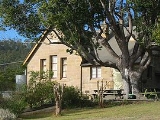
Wollombi's modest modern size is offset by its 19th century sandstone buildings and timber slab constructed cottages and sheds in a narrow valley junction containing Wollombi Brook and Congewai Creek. Narone and Yango Creeks also join these waterways near the village.
The area is home to an abundance of native birds, reptiles and other animals including kangaroo
Kangaroo
A kangaroo is a marsupial from the family Macropodidae . In common use the term is used to describe the largest species from this family, especially those of the genus Macropus, Red Kangaroo, Antilopine Kangaroo, Eastern Grey Kangaroo and Western Grey Kangaroo. Kangaroos are endemic to the country...
s, wallabies
Wallaby
A wallaby is any of about thirty species of macropod . It is an informal designation generally used for any macropod that is smaller than a kangaroo or wallaroo that has not been given some other name.-Overview:...
, wallaroo
Wallaroo
A Wallaroo is any of three closely related species of moderately large macropod, intermediate in size between the kangaroos and the wallabies. The name "wallaroo" is a portmanteau of wallaby and kangaroo. The term is not generally used by Australians...
s and wombat
Wombat
Wombats are Australian marsupials; they are short-legged, muscular quadrupeds, approximately in length with a short, stubby tail. They are adaptable in their habitat tolerances, and are found in forested, mountainous, and heathland areas of south-eastern Australia, including Tasmania, as well as...
s and is surrounded by imposing tree-lined mountains.
History
The original inhabitants of the locality are believed to be the Darkinjung peopleDarkinjung people
The Darkinjung are the in the Wyong and area and is a major landowner on the Central Coast, participating in formal joint management of some areas of state forest in the region. It represents over 450 local Aboriginal residents...
, though the Awabakal
Awabakal people
The Awabakal are an Indigenous Australian people of coastal New South Wales.Awaba is the word for Lake Macquarie – Awabakal therefore meaning people of Lake Macquarie...
and Wanaruah nations are also mentioned.
The town's name is an Aboriginal
Australian Aborigines
Australian Aborigines , also called Aboriginal Australians, from the latin ab originem , are people who are indigenous to most of the Australian continentthat is, to mainland Australia and the island of Tasmania...
term said to mean 'meeting place of the waters' or simply 'meeting place' ("Derived from Awabakal Aboriginal term for 'meeting of waters', but this cannot be linguistically verified. (Appleton; 1992). Also: meeting of the waters. (McCarthy; 1963)."). It was apparently pronounced 'Wu-lum-bee', though today it is pronounced Wo (as in wok) - lum (as in thumb) - bi (as in buy).
There are a vast number of historic Aboriginal sites in the surrounding countryside which is thought to have been used as a ceremonial meeting place as people from hundreds of kilometres visited the area and made their way to Mount Yengo
Mount Yengo
Mount Yengo is a mountain located several kilometers west from Wollombi, New South Wales, Australia, in Yengo National Park. The mountain is significant in Aboriginal mythology, as the Creator God, Biamie of the several neighbouring tribes surrounding the area.-References:...
- a place of great significance throughout the ancient nations of eastern Australia.
There are rock engravings, sharpening grooves, hand stencils, tribal markings and other images in caves and outcrops, frequent evidence of camping sites along the Brook and its tributary creeks, and two major mapping sites containing many engravings.
The establishment, development and significance of the township of Wollombi was directly connected with the construction and importance of the Great Northern Road in the early 19th century. The Howes Valley Rd (Putty Road
Putty Road
Putty Road is a New South Wales country road linking Windsor, on the fringes of Sydney, to Singleton. It is designated as State Route 69 and is about 150 kilometres long. It is the northern end of State Route 69, connecting with Metroad 9 in Windsor and New England Highway in Singleton...
) was completed in 1823, but travel along it was thought to be too difficult to be a success commercially.
Major Thomas Mitchell - Surveyor-General - formulated the idea of an inland route to open up transport to regions in northern NSW. Heneage Finch, who later settled in Laguna, surveyed the route for the Great Northern Road via Castle Hill
Castle Hill, New South Wales
Castle Hill is a suburb in the north-west of Sydney, in the state of New South Wales, Australia. Castle Hill is located 31 kilometres north-west of the Sydney central business district, in the Hills District of the Greater Western Sydney region...
, Wisemans Ferry
Wisemans Ferry, New South Wales
Wisemans Ferry is a town north of Sydney, in the state of New South Wales, Australia. Wisemans Ferry is located 75 kilometres north-west of the Sydney central business district in the local government areas of Hornsby Shire, The Hills Shire, City of Hawkesbury and City of Gosford.The town is a...
, St Albans
St Albans, New South Wales
St Albans is a small and historic village on the Macdonald River, New South Wales, Australia, about 94 kilometres north west of Sydney...
, Laguna and Wollombi.
At Wollombi, the road diverged toward Singleton and Muswellbrook
Muswellbrook, New South Wales
Muswellbrook, a corruption of 'Muscle Brook', is a town and Local Government Area in New South Wales, Australia. The original spelling and etymology of the town's name is a matter of some debate...
to the north, and Cessnock and Maitland
Maitland, New South Wales
Maitland is a city in the Lower Hunter Valley of New South Wales, Australia and the seat of Maitland City Council, situated on the Hunter River approximately by road north of Sydney and north-west of Newcastle...
to the north east.
Hundreds of convict
Convict
A convict is "a person found guilty of a crime and sentenced by a court" or "a person serving a sentence in prison", sometimes referred to in slang as simply a "con". Convicts are often called prisoners or inmates. Persons convicted and sentenced to non-custodial sentences often are not termed...
s began building the road from Castle Hill to Wollombi. One group was headquartered at Castle Hill where over 380 men were organised in seven road parties. They began work on the section of road south of the Hawkesbury. A second group, of 119 men, worked from Newcastle in two road parties, one between Newcastle and Wallis Plains (Maitland) and the other between Wallis Plains and Wollombi.
Road construction commenced in 1826 and was completed in 1831. Remnants such as stone culverts, bridges and retaining walls remain, particularly in the area between Wisemans Ferry and Wollombi, and are catalogued and cared for by the The Convict Trail Project.
During the years before the GNR was commenced, only a few large land grants (1000–2000 acre (404.7–809.4 ha)) were allocated along Cockfighter's Creek or the lower Wollombi Brook, to John Blaxland
John Blaxland
John Blaxland was a pioneer settler and explorer in Australia.-Early life:Blaxland was born in Kent, the eldest son of John Blaxland and Mary, née Parker, of Fordwich, Kent, England. He was the older brother of Gregory Blaxland. John Blaxland was educated at The King's School, Canterbury, later...
and - Rodd at Fordwich, Heneage Finch at Laguna and Thomas Crawford at Congewai. Richard Wiseman received 640 acre (259 ha) near Wollombi. After 1830 the holdings in the Wollombi Valley were about 100 acre (40 ha).
Surveyor GB White surveyed the village reserve at Wollombi into sections and allotments in 1833.
A horseman who travelled from Sydney to Patrick's Plains in 1827 along the line of road in progress took three days for the journey – the first day to Wiseman's Ferry - 49 miles (79 km). The second day to 'the head of the Wollombi' (about 12 mi (19 km) south of the future Wollombi village reserve) - 40 mi (64 km), and the third day to Patrick's Plains - 36 mi (58 km), made a total of 125 mi (201 km).
The settlement developed as a centre for the farming community and for travellers on the Great North Road. Then, on 12 June 1831, the steamship 'Sophie Jane' sailed from Sydney to the port of Morpeth
Morpeth, New South Wales
Morpeth is a suburb of the City of Maitland Local Government Area in the Hunter Region of New South Wales, Australia. It is located on the southern banks of the Hunter River at the border between the City of Maitland and Port Stephens Council LGAs...
on the Hunter River in eleven and a half hours. With the speed and carrying capacity of the ship far surpassing that of road transport to the Hunter region, the commercial significance of the Great Northern Road immediately diminished.
By the early 1840s, the inns operating at intervals along the Great North Road and its branch toward Maitland were (Solomon) Wiseman's at the Ferry, (Richard) Wiseman's Inn at the head of the Wollombi Valley (from 1827), Traveller's Test at Laguna (1835), Governor Gipps
George Gipps
Sir George Gipps was Governor of the colony of New South Wales, Australia, for eight years, between 1838 and 1846. His governorship was during a period of great change for New South Wales and Australia, as well as for New Zealand, which was administered as part of New South Wales for much of this...
at Wollombi (1840), Rising Sun at Millfield (1840s) and the Cock Inn on Cockfighter Creek (c1840s).
The foundation stone of Saint Michael's Catholic Church was laid near the Congewai Creek crossing (Cunneens Bridge) in 1840 but the church was moved to its present location following severe damage in the 1893 flood. St John's Anglican Church was built in 1846. The Wollombi Telegraph Office opened in 1860, the former Police station and Courthouse (now Endeavour Museum) was built c1866, the stone School building c1881 (the original school opened in 1852) and the timber General Store is well over a century old.
By 1850 the village had an Anglican and Catholic Church, a flour mill, a village cemetery and its own District Council. By 1851 the population was recorded as 105. By 1862 there were 1655 people living in the district with 233 in the village itself and by 1867 there were 1800 people in the area.
The 1860s were the years of greatest development. The production figures for 1867 were 26,856 bushels of wheat, 23,042 bushels of maize, 398 of barley, 680 of oats, 88 tons of potatoes, 7,502 lbs of tobacco and 180 gallons of wine. The livestock numbers in the valley were as follows: 5,853 head of cattle, 3,543 sheep and 1,449 pigs.
Rust devastated the area in the 1870s causing wheat crop failures. This undermined the economic base of the region and along with overfarming of the land causing a loss of productivity and severe floods removing topsoil, the district entered a period of decline which continues to the present time.
By 1911 the population of the village had reached a high of 406 but it had declined to 151 in 1961. At the 2006 census, the population of Wollombi was 264, consisting of 136 male and 128 female residents.
External links
- Wollombi Valley Arts Council
- Valley Artists
- Wollombi, New South Wales on OZpedia
- Wollombi Cemetery - Australian Cemeteries Index
- NPWS Information about Great North Road
- Greater Blue Mountains Area at UNESCO World Heritage Centre
- The Greater Blue Mountains Area, New South Wales, Australia at United Nations Environment Programme World Conservation Monitoring Centre
- Blue Mountains World Heritage Institute