
Whitecliff Bay
Encyclopedia
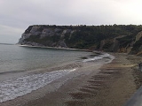
Whitecliff Bay is a sandy bay near the easternmost point of the Isle of Wight
, England
about 2 miles south-west of Bembridge
and just to the north of Culver Down
. It is a tourist site (the location of a holiday park), has a popular beach with two hundred metres of sand and shingle, and minimal facilities including 2 cafes. Access is limited and only possible down two steeply sloping concrete tracks.
It is of geological interest, being part of the Whitecliff Bay And Bembridge Ledges SSSI
.
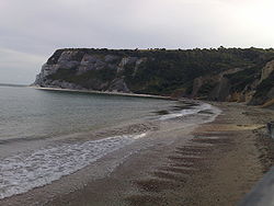
, has nearly identical geology to the latter, being a coastal section of the same strata which run east-west across the island. It displays a classic sequence of fossil-bearing Eocene
beds of soft sands and clays, separated by an unconformity from the underlying Cretaceous
Chalk Formation
forming the headland of Culver Down to its south. Due to geological folding of the Alpine orogeny
, the strata in the main section of the Bay are vertical, with younger rocks to the north.
Isle of Wight
The Isle of Wight is a county and the largest island of England, located in the English Channel, on average about 2–4 miles off the south coast of the county of Hampshire, separated from the mainland by a strait called the Solent...
, England
England
England is a country that is part of the United Kingdom. It shares land borders with Scotland to the north and Wales to the west; the Irish Sea is to the north west, the Celtic Sea to the south west, with the North Sea to the east and the English Channel to the south separating it from continental...
about 2 miles south-west of Bembridge
Bembridge
Bembridge is an affluent village and civil parish located on the easternmost point of the Isle of Wight. It had a population of 3,848 according to the 2001 census of the United Kingdom, leading to claims by residents that Bembridge is the largest village in England, and occasional claims that it is...
and just to the north of Culver Down
Culver Down
Culver Down is a chalk down to the north of Sandown, Isle of Wight.It is believed that its name derives from "Culfre" - old English for "dove"....
. It is a tourist site (the location of a holiday park), has a popular beach with two hundred metres of sand and shingle, and minimal facilities including 2 cafes. Access is limited and only possible down two steeply sloping concrete tracks.
It is of geological interest, being part of the Whitecliff Bay And Bembridge Ledges SSSI
Whitecliff Bay And Bembridge Ledges SSSI
Whitecliff Bay And Bembridge Ledges is a 131.6 hectare Site of special scientific interest which lies around the coastline of the eastern most part of the Isle of Wight from Bembridge harbour entrance, in the north, around Foreland and stretching to Whitecliff Bay to the south. The site was...
.
Geology
Whitecliff Bay, although lesser known than Alum BayAlum Bay
Alum Bay is a bay near the westernmost point of the Isle of Wight, England, within sight of the Needles. Of geological interest and a tourist attraction, the bay is noted for its multi-coloured sand cliffs.-Geology:...
, has nearly identical geology to the latter, being a coastal section of the same strata which run east-west across the island. It displays a classic sequence of fossil-bearing Eocene
Eocene
The Eocene Epoch, lasting from about 56 to 34 million years ago , is a major division of the geologic timescale and the second epoch of the Paleogene Period in the Cenozoic Era. The Eocene spans the time from the end of the Palaeocene Epoch to the beginning of the Oligocene Epoch. The start of the...
beds of soft sands and clays, separated by an unconformity from the underlying Cretaceous
Cretaceous
The Cretaceous , derived from the Latin "creta" , usually abbreviated K for its German translation Kreide , is a geologic period and system from circa to million years ago. In the geologic timescale, the Cretaceous follows the Jurassic period and is followed by the Paleogene period of the...
Chalk Formation
Chalk Formation
The Chalk Group is a lithostratigraphic unit in the northwestern part of Europe. It is characterised by thick deposits of chalk, a soft porous white limestone, deposited in a marine environment during the Upper Cretaceous period.Chalk is a limestone that consists of coccolith biomicrite...
forming the headland of Culver Down to its south. Due to geological folding of the Alpine orogeny
Alpine orogeny
The Alpine orogeny is an orogenic phase in the Late Mesozoic and Tertiary that formed the mountain ranges of the Alpide belt...
, the strata in the main section of the Bay are vertical, with younger rocks to the north.