

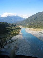
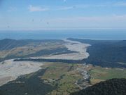
Whataroa River
Encyclopedia
River
A river is a natural watercourse, usually freshwater, flowing towards an ocean, a lake, a sea, or another river. In a few cases, a river simply flows into the ground or dries up completely before reaching another body of water. Small rivers may also be called by several other names, including...
in the southern West Coast
West Coast, New Zealand
The West Coast is one of the administrative regions of New Zealand, located on the west coast of the South Island, and is one of the more remote and most sparsely populated areas of the country. It is made up of three districts: Buller, Grey and Westland...
region of New Zealand
New Zealand
New Zealand is an island country in the south-western Pacific Ocean comprising two main landmasses and numerous smaller islands. The country is situated some east of Australia across the Tasman Sea, and roughly south of the Pacific island nations of New Caledonia, Fiji, and Tonga...
's South Island
South Island
The South Island is the larger of the two major islands of New Zealand, the other being the more populous North Island. It is bordered to the north by Cook Strait, to the west by the Tasman Sea, to the south and east by the Pacific Ocean...
. Its source is in the Southern Alps
Southern Alps
The Southern Alps is a mountain range extending along much of the length of New Zealand's South Island, reaching its greatest elevations near the island's western side...
and it flows north and northwest, passing the township of Whataroa
Whataroa
Whataroa is a small township in southern Westland on the West Coast of New Zealand's South Island. It is located on the western bank of the Whataroa River, with the village of Te Taho on the other side. State Highway 6 passes through Whataroa on its route from Ross to the Franz Josef Glacier...
on the eastern side before reaching the Tasman Sea
Tasman Sea
The Tasman Sea is the large body of water between Australia and New Zealand, approximately across. It extends 2,800 km from north to south. It is a south-western segment of the South Pacific Ocean. The sea was named after the Dutch explorer Abel Janszoon Tasman, the first recorded European...
just south of Abut Head
Abut Head
Abut Head is a forested headland on the West Coast of New Zealand's South Island. It is located north of the village of Whataroa and west of Harihari, and is southwest of the Westland District's main centre, Hokitika. On the southern side of the headland, the Whataroa River meets the Tasman Sea. To...
. The river is fed by many tributaries, such as the Perth River
Perth River
The Perth River is a river located in the Southern Alps in the West Coast region of New Zealand's South Island. Its source is in terrace icefields north of the Rangitata Divide and is joined by multiple tributaries, including a creek from Abel Lake. It features a number of rapids and passes...
, and is crossed by State Highway 6
New Zealand State Highway network
The New Zealand State Highway network is the major national highway network in New Zealand. Just under 100 roads in both the North and South Islands are State Highways...
on its route between Whataroa and Te Taho
Te Taho
Te Taho is a small farming community of eleven houses in the West Coast region of the South Island of New Zealand between the north bank of the Whataroa River and Mt Hercules. It is located slightly inland from the coast....
.
Whitewater
Whitewater
Whitewater is formed in a rapid, when a river's gradient increases enough to disturb its laminar flow and create turbulence, i.e. form a bubbly, or aerated and unstable current; the frothy water appears white...
rafting
Rafting
Rafting or white water rafting is a challenging recreational outdoor activity using an inflatable raft to navigate a river or other bodies of water. This is usually done on white water or different degrees of rough water, in order to thrill and excite the raft passengers. The development of this...
takes place on the river as an adventure tourism activity. Access to the upper reaches of the river for rafting is either via hiking or helicopter.