
Westwood, Boyd County, Kentucky
Encyclopedia
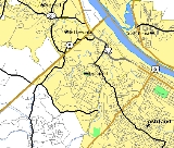
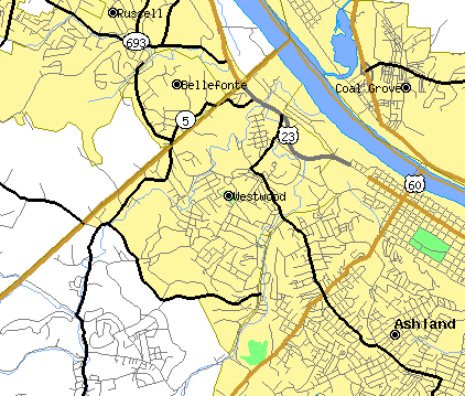
Westwood is a census-designated place (CDP) in Boyd County
, Kentucky
, United States
. The population was 4,888 at the 2000 census. It serves as a suburb of Ashland, Kentucky
. Westwood is closely affiliated with Ashland, as it shares its zipcode and bus system with the city.
Westwood is a part of the Huntington-Ashland, WV-KY-OH, Metropolitan Statistical Area
(MSA). As of the 2000 census, the MSA had a population of 288,649.
According to the United States Census Bureau
, the CDP has a total area of 4 square miles (10.4 km²), of which, 3.9 square miles (10.1 km²) of it is land and 0.1 square mile (0.258998811 km²) of it (2.26%) is water.
Westwood is located mostly on a flat ridge west of the Ohio River. The southern boundary is the Ashland city limits, the northern boundary is Hood's Creek. The flat elevation in which Westwood is located was created by the ancient Teays River
. The course of the river was altered due to glacial formations around two million years ago. It resulted in many flat hill tops that are commonly found in Boyd and Greenup Counties which are evident on aerial satellite imagery. Outside of this ancient river bed, the terrain is "ridge and valley" as is typical in most of Eastern Kentucky
.
As of the census
of 2000, there were 4,888 people, 2,004 households, and 1,468 families residing in the CDP. The population density
was 1,253.1 people per square mile (483.9/km²). There were 2,191 housing units at an average density of 561.7/sq mi (216.9/km²). The racial makeup of the CDP was 98.20% White, 0.47% African American, 0.08% Native American, 0.37% Asian, 0.04% from other races
, and 0.84% from two or more races. Hispanic or Latino of any race were 0.49% of the population.
There were 2,004 households out of which 26.6% had children under the age of 18 living with them, 58.0% were married couples
living together, 11.3% had a female householder with no husband present, and 26.7% were non-families. 23.9% of all households were made up of individuals and 10.5% had someone living alone who was 65 years of age or older. The average household size was 2.43 and the average family size was 2.84.
In the CDP the population was spread out with 20.9% under the age of 18, 9.0% from 18 to 24, 26.1% from 25 to 44, 27.0% from 45 to 64, and 16.9% who were 65 years of age or older. The median age was 41 years. For every 100 females there were 95.1 males. For every 100 females age 18 and over, there were 90.8 males.
The median income for a household in the CDP was $29,394, and the median income for a family was $36,094. Males had a median income of $30,196 versus $19,938 for females. The per capita income
for the CDP was $18,455. About 9.1% of families and 14.2% of the population were below the poverty line, including 20.0% of those under age 18 and 7.6% of those age 65 or over.
.
Boyd County, Kentucky
Boyd County is a county located in the U.S. state of Kentucky. It was formed in 1860. Its are found at the northeastern edge of the state the near the Ohio River and Big Sandy River, nestled in the verdant rolling hills of Appalachia. The county seat is Catlettsburg. Its largest municipality is...
, Kentucky
Kentucky
The Commonwealth of Kentucky is a state located in the East Central United States of America. As classified by the United States Census Bureau, Kentucky is a Southern state, more specifically in the East South Central region. Kentucky is one of four U.S. states constituted as a commonwealth...
, United States
United States
The United States of America is a federal constitutional republic comprising fifty states and a federal district...
. The population was 4,888 at the 2000 census. It serves as a suburb of Ashland, Kentucky
Ashland, Kentucky
Ashland, formerly known as Poage Settlement, is a city in Boyd County, Kentucky, United States, nestled along the banks of the Ohio River. The population was 21,981 at the 2000 census. Ashland is a part of the Huntington-Ashland, WV-KY-OH, Metropolitan Statistical Area . As of the 2000 census, the...
. Westwood is closely affiliated with Ashland, as it shares its zipcode and bus system with the city.
Westwood is a part of the Huntington-Ashland, WV-KY-OH, Metropolitan Statistical Area
Huntington-Ashland, WV-KY-OH, Metropolitan Statistical Area
The Huntington-Ashland-Ironton metropolitan area is a United States metropolitan area that includes five counties in West Virginia, Kentucky and Ohio. As of the 2000 census, the MSA had a population of 288,649. A July 1, 2009 estimate placed the population at 285,624. The MSA is nestled along the...
(MSA). As of the 2000 census, the MSA had a population of 288,649.
History
Westwood was developed beginning in the 1920s as a residential addition to Ashland, although as of 2010, annexation has never occurred. Employees of the American Rolling Mill Company were the majority of the new homeowners who lived in Westwood. Most lots were sold and homes were built from 1920–1950, although some subdivisions have sprung up since then in the Westwood area. The population has grown over the years but the community was never incorporated. As of the 2000 census, Westwood had nearly 5,000 residents, and was identified as a CDP (Census Designated Place) by the U.S. Census Bureau, as it is a community in its own right. According to census figures, it is one of the largest unincorporated communities in the state of Kentucky.Geography
Westwood is located at 38°28′57"N 82°40′41"W (38.482422, -82.678028).According to the United States Census Bureau
United States Census Bureau
The United States Census Bureau is the government agency that is responsible for the United States Census. It also gathers other national demographic and economic data...
, the CDP has a total area of 4 square miles (10.4 km²), of which, 3.9 square miles (10.1 km²) of it is land and 0.1 square mile (0.258998811 km²) of it (2.26%) is water.
Westwood is located mostly on a flat ridge west of the Ohio River. The southern boundary is the Ashland city limits, the northern boundary is Hood's Creek. The flat elevation in which Westwood is located was created by the ancient Teays River
Teays River
The Teays River was an important preglacial river that drained much of the area now drained by the Ohio River, and more. Traces of the Teays across northern Ohio and Indiana are represented by a network of river valleys. These valleys were carved in the late Cenozoic and eventually led to the...
. The course of the river was altered due to glacial formations around two million years ago. It resulted in many flat hill tops that are commonly found in Boyd and Greenup Counties which are evident on aerial satellite imagery. Outside of this ancient river bed, the terrain is "ridge and valley" as is typical in most of Eastern Kentucky
Eastern Mountain Coal Fields
The Eastern Mountain Coal Fields is part of the Central Appalachian bituminous coal field, covering all or parts of 30 Kentucky counties and adjoining areas in Ohio, West Virginia, Virginia and Tennessee. It covers an area from the Allegheny Mountains in the east across the Cumberland Plateau and...
.
Demographics
As of the census
Census
A census is the procedure of systematically acquiring and recording information about the members of a given population. It is a regularly occurring and official count of a particular population. The term is used mostly in connection with national population and housing censuses; other common...
of 2000, there were 4,888 people, 2,004 households, and 1,468 families residing in the CDP. The population density
Population density
Population density is a measurement of population per unit area or unit volume. It is frequently applied to living organisms, and particularly to humans...
was 1,253.1 people per square mile (483.9/km²). There were 2,191 housing units at an average density of 561.7/sq mi (216.9/km²). The racial makeup of the CDP was 98.20% White, 0.47% African American, 0.08% Native American, 0.37% Asian, 0.04% from other races
Race (United States Census)
Race and ethnicity in the United States Census, as defined by the Federal Office of Management and Budget and the United States Census Bureau, are self-identification data items in which residents choose the race or races with which they most closely identify, and indicate whether or not they are...
, and 0.84% from two or more races. Hispanic or Latino of any race were 0.49% of the population.
There were 2,004 households out of which 26.6% had children under the age of 18 living with them, 58.0% were married couples
Marriage
Marriage is a social union or legal contract between people that creates kinship. It is an institution in which interpersonal relationships, usually intimate and sexual, are acknowledged in a variety of ways, depending on the culture or subculture in which it is found...
living together, 11.3% had a female householder with no husband present, and 26.7% were non-families. 23.9% of all households were made up of individuals and 10.5% had someone living alone who was 65 years of age or older. The average household size was 2.43 and the average family size was 2.84.
In the CDP the population was spread out with 20.9% under the age of 18, 9.0% from 18 to 24, 26.1% from 25 to 44, 27.0% from 45 to 64, and 16.9% who were 65 years of age or older. The median age was 41 years. For every 100 females there were 95.1 males. For every 100 females age 18 and over, there were 90.8 males.
The median income for a household in the CDP was $29,394, and the median income for a family was $36,094. Males had a median income of $30,196 versus $19,938 for females. The per capita income
Per capita income
Per capita income or income per person is a measure of mean income within an economic aggregate, such as a country or city. It is calculated by taking a measure of all sources of income in the aggregate and dividing it by the total population...
for the CDP was $18,455. About 9.1% of families and 14.2% of the population were below the poverty line, including 20.0% of those under age 18 and 7.6% of those age 65 or over.
Education
Westwood has its own school district, the Fairview Independent School DistrictFairview Independent Schools (Kentucky)
Fairview Independent Schools is a public school district based in Boyd County, Kentucky, United States. The district serves the area within the census-designated place of Westwood. The district consists of two schools: Fairview High School and Fairview Elementary School...
.