

Western Highway, Belize
Encyclopedia
Highway
A highway is any public road. In American English, the term is common and almost always designates major roads. In British English, the term designates any road open to the public. Any interconnected set of highways can be variously referred to as a "highway system", a "highway network", or a...
s in Belize
Belize
Belize is a constitutional monarchy and the northernmost country in Central America. Belize has a diverse society, comprising many cultures and languages. Even though Kriol and Spanish are spoken among the population, Belize is the only country in Central America where English is the official...
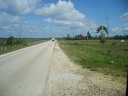
. It originates in Belize City
Belize City
Belize City is the largest city in the Central American nation of Belize. Unofficial estimates place the population of Belize City at 70,000 or more. It is located at the mouth of the Belize River on the coast of the Caribbean. The city is the country's principal port and its financial and...
, runs west through Hattieville
Hattieville
Hattieville, sometimes also known as Hattieville Village, is a town in the Belize District of the nation of Belize. It is located at 17N 88W, at an elevation of 196 feet above mean sea level, and has a population of about 1,300 people...
, Belize Zoo
Belize Zoo
The Belize Zoo and Tropical Education Center is a zoo in Belize, located some west of Belize City on the Western Highway. Set in , the zoo was founded in 1983 by Sharon Matola. It is home to more than 125 animals of about 48 species, all native to Belize. The natural environment of Belize is left...
, the capital city of Belmopan
Belmopan
Belmopan , estimated population 20,000 is the capital city of Belize.Belmopan is located at , at an altitude of 76 metres above sea level. Belmopan was constructed just to the east of Belize River, inland from the former capital, the port of Belize City, after that city's near destruction by...
(northern outskirts), San Ignacio Cayo
San Ignacio Cayo
San Ignacio is a town in western Belize that serves as the capital of Cayo District. It got its start from Mahogany and chicle production during British rule...
, San José Succotz (across the river from Xunantunich
Xunantunich
Xunantunich is a Maya archaeological site in western Belize, about 80 miles west of Belize City , in the Cayo District. Xunantunich is located atop a ridge above the Mopan River, within sight of the Guatemala border...
archaeological site) and terminates at the Guatemala
Guatemala
Guatemala is a country in Central America bordered by Mexico to the north and west, the Pacific Ocean to the southwest, Belize to the northeast, the Caribbean to the east, and Honduras and El Salvador to the southeast...
n border at Benque Viejo. The highway bisects the country and ties the eastern and western parts of Belize together. A new steel bridge over Beaver Dam Creek was constructed to replace the broken concrete one.
Junction list
| District | km | Mile | Destination | Notes |
|---|---|---|---|---|
| Belize Belize District The Belize District is a district of the nation of Belize, with its district capital being the nation's largest city, Belize City.- Settlements :... |
0.0 | 0.0 | Central American Boulevard to Northern Highway Northern Highway, Belize The Northern Highway in Belize joins Belize City through Orange Walk Town and Corozal Town with the Mexican border at the state of Quintana Roo. Crude side-roads suitable only for over-land vehicles connect to such localities as Aguas Turbias, on the corner where Belize, Mexico and Guatemala... and Cemetery Road |
Elevation, 2 metres |
| 2.6 | 1.6 | Faber Road | Marks approximate west edge of Belize City; elevation, 8 metres | |
| 23.1 | 14.3 | Burrell Boom Road | 19.1 km to Northern Highway; elevation, 6 metres | |
| 25.6 | 15.9 | Junction | Access to Hattieville Hattieville Hattieville, sometimes also known as Hattieville Village, is a town in the Belize District of the nation of Belize. It is located at 17N 88W, at an elevation of 196 feet above mean sea level, and has a population of about 1,300 people... |
|
| 46.9 | 29.1 | Coastal Highway (Manatee Highway) | Near La Democracia, Belize District Belize District The Belize District is a district of the nation of Belize, with its district capital being the nation's largest city, Belize City.- Settlements :... ; Coastal Highway extends 57 km to join Hummingbird Highway near Dangriga Dangriga Dangriga, formerly known as Stann Creek Town, is a town in southern Belize, located on the Caribbean coast at the mouth of Stann Creek. It is the capital of Belize's Stann Creek District and also the largest town in southern Belize... ; elevation, 32 metres |
|
| Cayo Cayo District Cayo District is a district in the west of the nation of Belize. The District capital is the town of San Ignacio.- Geography :The Cayo District is the largest district in Belize. It is located on the western side of the country which borders Guatemala. The nation's capital, Belmopan, is... |
74.6 | 46.3 | Access road to Belmopan airstrip | Elevation, 54 metres |
| 76.0 | 47.2 | Hummingbird Highway Hummingbird Highway The Hummingbird Highway is one of the four major highways in Belize. It connects the Western Highway outside of Belmopan, Cayo District with the Southern Highway outside of Dangriga, Stann Creek District. It partially follows, and sometimes uses the infrastructure of, the former Stann Creek Railway... |
Access to city of Belmopan Belmopan Belmopan , estimated population 20,000 is the capital city of Belize.Belmopan is located at , at an altitude of 76 metres above sea level. Belmopan was constructed just to the east of Belize River, inland from the former capital, the port of Belize City, after that city's near destruction by... ; elevation, 43 metres |
|
| 99.9 | 62.1 | Chiquibul Road | Elevation, 80 metres | |
| 110.3 | 68.5 | Bridge over Belize River | Highway enters San Ignacio; elevation, 62 metres | |
| 124.3 | 77.2 | Guatemala Guatemala Guatemala is a country in Central America bordered by Mexico to the north and west, the Pacific Ocean to the southwest, Belize to the northeast, the Caribbean to the east, and Honduras and El Salvador to the southeast... border |
Elevation, 87 metres |