
West End, Queensland
Encyclopedia
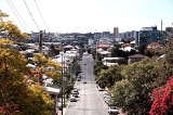
West End is an inner-city suburb of southern Brisbane
.
.
West End was one of the first suburbs of Brisbane to be serviced by a tram
line, being opened in 1885. Initially the tram was horse-drawn and terminated in Boundary Street, but in 1897 the line was electrified and extended to the southern end of Hardgrave Road, via Vulture Street. It was subsequently extended down Hoogley Street to the ferry
terminus at the end of Hoogley Street. The tram line closed on 13 April 1969.
The former Tristram's Drink Factory, 79 Boundary St, West End, built in 1928 and one of Australia's best examples of the Mission Revival Style architecture
was converted into a market in the 1990s and remains a heritage landmark of West End.
Scenes for the feature film Jucy
(2010) were shot at the now-defunct video store Trash Video in the suburb.
The suburb was affected by the 2010–2011 Queensland floods
as the Brisbane River broke its banks. From 11 January low-lying areas of the suburb and other places in Brisbane were evacuated.
to the west and the south. The south-western part of West End, along the Brisbane River, is also referred to as Hill End.
West End is adjacent to the suburbs of South Brisbane
and Highgate Hill
. These three suburbs make up a peninsula of the Brisbane River
.
The Aboriginal name for the area is Kurilpa, which means place of the water rat.
In recent times, students and academics have moved into West End, taking advantage of the area's proximity to the University of Queensland
, Griffith University
Southbank (including Queensland Conservatorium) and Nathan campuses and the QUT. West End's inner city location has also attracted many young professionals to the area.
Along with the influx of students and young professionals, there has been a growing number of cafes, restaurants, and bars - many with an ethnic, vegetarian or organic emphasis. With these changes, West End is widely seen as Brisbane's home for a younger "chic
" or "hipster
" crowd who represent a modern alternative take on urban life.
law
s seeking to preserve the historical character e.g. tin roofing. Contrasting sharply with the historic homes are new buildings of contemporary designs. Prices for all types of properties have been increasing dramatically in recent decades. According to REIQ, the median unit/town-house price in West End for 2005 is $310,000, and the median house price is $490,500.
A flood flag map for West End can be found at the Brisbane City Council website.
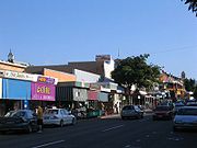 The area's major attraction is its café
and restaurant
scene, as well as its shopping, which is centred along Boundary Street. It is also known for its high concentration of ethnic and organic grocery stores. Davies Park on the riverside hosts one of the largest Farmer's markets in Greater Brisbane
every Saturday between 6am and 2pm.
West End has an industrial backbone, in particular, along Montague Road down to Riverside Drive. Given the value of riverside property now that flooding is better managed, factories are now being sold to make way for upscale waterfront apartments. This is part of a plan to increase population densities in near-city suburbs. It will significantly affect the ability of working class people to remain in the area and change the economic make-up of the area. As such, West End is currently undergoing urban renewal, with an enormous change in real estate prices, and new development changing the area demographic.
, commonly referred to as "State High". State High is a partially selective co-educational facility that is recognised as Queensland's premier public school. State High's outstanding reputation means that many families buy or rent in the area in order to ensure a place for their children at State High.
West End State Primary School is located on the corner of Vulture Street and Hardgrave Road.
CityCat services leave from the West End ferry wharf in Orleigh Street. The ferry terminal was destroyed in the 2011 floods. It was replaced and operating on the 24 July 2011.
Electronically secured BCC bicycle sheds exist near the West End Ferry Terminal and on Montague Road.
Brisbane
Brisbane is the capital and most populous city in the Australian state of Queensland and the third most populous city in Australia. Brisbane's metropolitan area has a population of over 2 million, and the South East Queensland urban conurbation, centred around Brisbane, encompasses a population of...
.
History
West End was named by early English settlers who found the area reminiscent of the West End of LondonWest End of London
The West End of London is an area of central London, containing many of the city's major tourist attractions, shops, businesses, government buildings, and entertainment . Use of the term began in the early 19th century to describe fashionable areas to the west of Charing Cross...
.
West End was one of the first suburbs of Brisbane to be serviced by a tram
Tram
A tram is a passenger rail vehicle which runs on tracks along public urban streets and also sometimes on separate rights of way. It may also run between cities and/or towns , and/or partially grade separated even in the cities...
line, being opened in 1885. Initially the tram was horse-drawn and terminated in Boundary Street, but in 1897 the line was electrified and extended to the southern end of Hardgrave Road, via Vulture Street. It was subsequently extended down Hoogley Street to the ferry
Ferry
A ferry is a form of transportation, usually a boat, but sometimes a ship, used to carry primarily passengers, and sometimes vehicles and cargo as well, across a body of water. Most ferries operate on regular, frequent, return services...
terminus at the end of Hoogley Street. The tram line closed on 13 April 1969.
The former Tristram's Drink Factory, 79 Boundary St, West End, built in 1928 and one of Australia's best examples of the Mission Revival Style architecture
Mission Revival Style architecture
The Mission Revival Style was an architectural movement that began in the late 19th century for a colonial style's revivalism and reinterpretation, which drew inspiration from the late 18th and early 19th century Spanish missions in California....
was converted into a market in the 1990s and remains a heritage landmark of West End.
Scenes for the feature film Jucy
Jucy
Jucy is an Australian comedy feature film produced in 2010 about the womance between two best female friends. The film was written by Stephen Vagg, directed by Louise Alston and produced by Kelly Chapman...
(2010) were shot at the now-defunct video store Trash Video in the suburb.
The suburb was affected by the 2010–2011 Queensland floods
2010–2011 Queensland floods
A series of floods hit Australia, beginning in December 2010, primarily in the state of Queensland including its capital city, Brisbane. The floods forced the evacuation of thousands of people from towns and cities. At least seventy towns and over 200,000 people were affected. Damage initially was...
as the Brisbane River broke its banks. From 11 January low-lying areas of the suburb and other places in Brisbane were evacuated.
Geography
Geographically, West End is bounded by the Brisbane RiverBrisbane River
The Brisbane River is the longest river in south east Queensland, Australia, and flows through the city of Brisbane, before emptying into Moreton Bay. John Oxley was the first European to explore the river who named it after the Governor of New South Wales, Thomas Brisbane in 1823...
to the west and the south. The south-western part of West End, along the Brisbane River, is also referred to as Hill End.
West End is adjacent to the suburbs of South Brisbane
South Brisbane, Queensland
South Brisbane is an inner city suburb of Brisbane, Australia located on the southern bank of the Brisbane River, directly connected to the central business district by the Kurilpa, Victoria and Goodwill bridges....
and Highgate Hill
Highgate Hill, Queensland
Highgate Hill is suburb of inner Brisbane, Australia and is located 2 km south of the Brisbane CBD on the Brisbane River. The topography of the suburb is undulating hills no more than above sea level....
. These three suburbs make up a peninsula of the Brisbane River
Brisbane River
The Brisbane River is the longest river in south east Queensland, Australia, and flows through the city of Brisbane, before emptying into Moreton Bay. John Oxley was the first European to explore the river who named it after the Governor of New South Wales, Thomas Brisbane in 1823...
.
The Aboriginal name for the area is Kurilpa, which means place of the water rat.
Demography
According to the 2001 national census 65% of residents in West End are individuals or families without children with 35% being those with children. The suburb has traditionally been home to Brisbane's largest Indigenous Australian and Greek communities, as well as significant Chinese and Italian communities. For this reason, West End has often been cited as one of Brisbane's most successful multicultural areas.In recent times, students and academics have moved into West End, taking advantage of the area's proximity to the University of Queensland
University of Queensland
The University of Queensland, also known as UQ, is a public university located in state of Queensland, Australia. Founded in 1909, it is the oldest and largest university in Queensland and the fifth oldest in the nation...
, Griffith University
Griffith University
Griffith University is a public, coeducational, research university located in the southeastern region of the Australian state of Queensland. The university has five satellite campuses located in the Gold Coast, Logan City and in the Brisbane suburbs of Mount Gravatt, Nathan and South Bank. Current...
Southbank (including Queensland Conservatorium) and Nathan campuses and the QUT. West End's inner city location has also attracted many young professionals to the area.
Along with the influx of students and young professionals, there has been a growing number of cafes, restaurants, and bars - many with an ethnic, vegetarian or organic emphasis. With these changes, West End is widely seen as Brisbane's home for a younger "chic
Chic (style)
Chic , meaning 'stylish' or 'smart', is an element of fashion.-Etymology:Chic is a French word, established in English since at least the 1870s...
" or "hipster
Hipster (contemporary subculture)
Hipsters are a subculture of young, recently settled urban middle class adults and older teenagers with musical interests mainly in alternative rock that appeared in the 1990s...
" crowd who represent a modern alternative take on urban life.
Planning and development
Just over 50% of the dwellings are standalone houses and 37% are higher density residential properties, including multi-storey blocks of apartments and units. Some houses are covered by historic preservationHistoric preservation
Historic preservation is an endeavor that seeks to preserve, conserve and protect buildings, objects, landscapes or other artifacts of historical significance...
law
Law
Law is a system of rules and guidelines which are enforced through social institutions to govern behavior, wherever possible. It shapes politics, economics and society in numerous ways and serves as a social mediator of relations between people. Contract law regulates everything from buying a bus...
s seeking to preserve the historical character e.g. tin roofing. Contrasting sharply with the historic homes are new buildings of contemporary designs. Prices for all types of properties have been increasing dramatically in recent decades. According to REIQ, the median unit/town-house price in West End for 2005 is $310,000, and the median house price is $490,500.
A flood flag map for West End can be found at the Brisbane City Council website.
Economy
Café
A café , also spelled cafe, in most countries refers to an establishment which focuses on serving coffee, like an American coffeehouse. In the United States, it may refer to an informal restaurant, offering a range of hot meals and made-to-order sandwiches...
and restaurant
Restaurant
A restaurant is an establishment which prepares and serves food and drink to customers in return for money. Meals are generally served and eaten on premises, but many restaurants also offer take-out and food delivery services...
scene, as well as its shopping, which is centred along Boundary Street. It is also known for its high concentration of ethnic and organic grocery stores. Davies Park on the riverside hosts one of the largest Farmer's markets in Greater Brisbane
Brisbane
Brisbane is the capital and most populous city in the Australian state of Queensland and the third most populous city in Australia. Brisbane's metropolitan area has a population of over 2 million, and the South East Queensland urban conurbation, centred around Brisbane, encompasses a population of...
every Saturday between 6am and 2pm.
West End has an industrial backbone, in particular, along Montague Road down to Riverside Drive. Given the value of riverside property now that flooding is better managed, factories are now being sold to make way for upscale waterfront apartments. This is part of a plan to increase population densities in near-city suburbs. It will significantly affect the ability of working class people to remain in the area and change the economic make-up of the area. As such, West End is currently undergoing urban renewal, with an enormous change in real estate prices, and new development changing the area demographic.
Schools
West End is in the catchment for Brisbane State High SchoolBrisbane State High School
Brisbane State High School is a partially selective, co-educational, state secondary school, located in Brisbane, Queensland, Australia. It is a member of the Great Public Schools' Association of Queensland, and the Queensland Girls' Secondary Schools Sports Association...
, commonly referred to as "State High". State High is a partially selective co-educational facility that is recognised as Queensland's premier public school. State High's outstanding reputation means that many families buy or rent in the area in order to ensure a place for their children at State High.
West End State Primary School is located on the corner of Vulture Street and Hardgrave Road.
Transport
The suburb is well serviced by buses and ferries. Bus services include Route 199 BUZ to New Farm-City-West End Ferry, leaving every 5 minutes, Route 192 University of Queensland to City, Route 198 Highgate Hill Hail & Ride (Coles West End-PA Hospital-Woolloongabba-Vulture St-Coles West End) and a City Glider service along Montague Road.CityCat services leave from the West End ferry wharf in Orleigh Street. The ferry terminal was destroyed in the 2011 floods. It was replaced and operating on the 24 July 2011.
Electronically secured BCC bicycle sheds exist near the West End Ferry Terminal and on Montague Road.