
Wereham
Encyclopedia
Wereham is a small village and civil parish
in the English
county of Norfolk
.
and is on the main A134 road
; it is some five miles to the east of the town of Downham Market
and thirteen miles from King's Lynn
. Neighbouring villages include Boughton
, Fincham
, Crimplesham
, West Dereham
, Wretton
and Stoke Ferry
.
depicts 'Billy the Seal', one of Wereham's most famous residents from the 1920s.
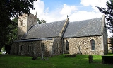
 The Parish Church, dedicated to St Margaret of Antioch is in the centre of the village.
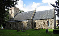
Civil parish
In England, a civil parish is a territorial designation and, where they are found, the lowest tier of local government below districts and counties...
in the English
England
England is a country that is part of the United Kingdom. It shares land borders with Scotland to the north and Wales to the west; the Irish Sea is to the north west, the Celtic Sea to the south west, with the North Sea to the east and the English Channel to the south separating it from continental...
county of Norfolk
Norfolk
Norfolk is a low-lying county in the East of England. It has borders with Lincolnshire to the west, Cambridgeshire to the west and southwest and Suffolk to the south. Its northern and eastern boundaries are the North Sea coast and to the north-west the county is bordered by The Wash. The county...
.
Location
Wereham lies in the Wissey valleyRiver Wissey
The River Wissey is a river in Norfolk, eastern England. It rises near Bradenham, and flows for nearly to join the River Great Ouse at Fordham...
and is on the main A134 road
A134 road
The A134 road runs from Colchester to Kings Lynn. Other towns on the A134 road include Sudbury, Bury St. Edmunds and Thetford....
; it is some five miles to the east of the town of Downham Market
Downham Market
Downham Market is a town and civil parish in Norfolk, England. It lies on the edge of the Fens, on the River Great Ouse, some 20 km south of the town of King's Lynn, 60 km west of the city of Norwich and the same distance north of the city of Cambridge....
and thirteen miles from King's Lynn
King's Lynn
King's Lynn is a sea port and market town in the ceremonial county of Norfolk in the East of England. It is situated north of London and west of Norwich. The population of the town is 42,800....
. Neighbouring villages include Boughton
Boughton, Norfolk
Boughton is a village and a civil parish in the English county of Norfolk. The village is west of Norwich, south-south-west of King’s Lynn and north-east of London. The nearest town is Downham Market which is east of the village. The village is a north of the route A134 which links King’s Lynn...
, Fincham
Fincham
Fincham is a civil parish in North West Norfolk, England, with a population of approximately 500. Located on the A1122, it is 12 miles south of King's Lynn. It neighbours the villages of Shouldham, Boughton, and Barton Bendish and is part of the King's Lynn and West Norfolk local governing district...
, Crimplesham
Crimplesham
Crimplesham is a village and civil parish in the English county of Norfolk. It is situated 4 km west of the small town of Downham Market, 20 km south of the larger town of King's Lynn, and 60 km west of the city of Norwich....
, West Dereham
West Dereham
West Dereham is a village and civil parish in the English county of Norfolk.It covers an area of and had a population of 440 in 176 households as of the 2001 census....
, Wretton
Wretton
Wretton is a village and civil parish in the English county of Norfolk.It covers an area of and had a population of 392 in 155 households as of the 2001 census....
and Stoke Ferry
Stoke Ferry
Stoke Ferry is a civil parish in the English county of Norfolk, 6.5 miles south-east of Downham Market. The village lies on the River Wissey which has also been known as the River Stoke....
.
History
In the centre of the village is the pond - known locally as the pit. Nearby on the village green, the Village signVillage sign
A village sign in some areas of England is a symbol of a village's history, heritage, or culture. They differ from regular road signs in that they are decorative, with the designs usually depicting some aspect of the history of the village...
depicts 'Billy the Seal', one of Wereham's most famous residents from the 1920s.
Facilities
Wereham once had four pubs the George and Dragon, The Crown, The Nags Head and The Chequers however only the George and Dragon remains. The village also had a school, however this closed in the 1980s.External links
- GENUKI page
- The Wereham Category of the Group 4 News Website.
- The Wereham Category of the Stoke Ferry Website includes Parish Council meeting minutes.