

Weldford Parish, New Brunswick
Encyclopedia
Weldford is a local service district found in Kent County
, New Brunswick
, Canada
that was established in 1835 with a local Agricultural Association and named for John W. Weldon and John P. Ford, who were Members of the Legislative Assembly for Kent County in 1835.
A 1920’s Newspaper Article states "The first Representative for the County of Kent was Judge Weldon who was returned in 1828 and continued as sole member until representation was increased and Mr. J. P. Ford, formerly of Halifax, who built the Ford Mills in the Richibucto River was returned with him. Colonel David McAlmon subsequently took Mr. Ford’s place and he and Judge Weldon were returned for four years. McAlmon was later substituted for Senator Wark and he and Weldon were members until 1850."
In the 2006 Census
Weldford had a population of 1,426.
Latitude : 46° 29' Longitude : 64° 55'
 Bass River is a small farming and forestry community located in Weldford that developed around the Bass River, a fresh water tributary of the Richibucto River
. In 1871 Bass River had a population of 400, in 1898 Bass River had 1 post office, 3 stores, 1 grist mill, 2 churches and a population of 350.
Bass River is home of the Bass River County Fair held annually on July 12 weekend since 1974. The week long celebration of local English, Irish and Scot's heritage has featured events such as the double horse haul, a parade, horse and car shows, circus rides and games for family and children as well as providing top notch New Brunswick musical entertainment from artists such as Kevin Chase and Don Coleman. A weekend regular at Bass River Country Club is country music singer and songwriter, Valerie Thompson with Heartland who makes her home in Bass River and the community is also home to a rock and roll band named Cactus Tung, once featured on the New Brunswick Music website. The community center hosts a softball field, outdoor skating rink, horse show display spaces and barn, picnic area, playground equipment and open spaces available for the communities enjoyment.
Thompson's General Store in Bass River has a long-standing history, conveniently located along Route 116 and currently owned by Glen Thompson of GlenHar Builders Ltd., Quispamsis, New Brunswick. Glen was raised in Bass River and the Thompson family of Northern Ireland with Scottish roots has long standing roots in the community with a Road from St. Mark's Presbyterian Church to Mrs. Thompson's constructed in 1854. The church, near Walker's Mill, a thriving business in the 1880s, was constructed about the year 1840 and was the center of community living for early settlers to the area including surnames Campbell, Walker, Stewart, McKendrick and McDougall.
The general store in Bass River was at one time owned by the ancestors of Major John McKendrick Hughes, 1882–1967, with The 151st Battalion Company: C and honoured for his work with French civilians while serving as an Agricultural Officer in the fall of 1917. Major Hughes was made an Officier l'Ordre du merite agricole, one of four Canadian officers to receive this French award. His accomplishments are highlighted in a book which describes his experience and service with the Armistice Commission. The book was written by his grandson, John R. Hughes, based on letters the Officer sent home from the field to his wife Sarah which were compiled and published in May 2005, University of Alberta Press, 'The Unwanted, Great War Letters from the Field'. Major Hughes was descendant from Donald McKendrick and Catherine Little who are noted on the land grant map at Bass River having moved to the area about 1810 from Prince Edward Island where the family had originally settled after immigration from Scotland in 1770.
Krista Betts is a Canadian Women's Wrestling Gold Medal Winner and recipient of the 2005 Roland McLenahan Award, given to New Brunswick Athletes who best combine excellence in sport, perseverance and sportsmanship and who has made a significant contribution to the New Brunswick team effort at the Canada Games. In 2005, Krista Betts made Canada Games
history by becoming the first gold medal winner for women's wrestling at the Canada Games, she led Team NB at the closing ceremonies and was also New Brunswick's flag bearer. Betts wrestled in the 2009 Romanian International Junior Cup which took place in Resita Romania on May 19–22 and won against Disislava Kuncheva(Bulgaria) 2-0, 7-0, she beat Ileana Dobrescu(Romania) win 6-0, 7-3 in the final match to win gold. The whole week before the tournament Krista along with the rest of the Canadian National Team had a training camp in Resita and after the tournament was over they traveled to Schifferstadt, Germany for another training camp and practiced at one of the sport schools there. Unfortunately, Betts was hurt during the week, suffering a costochondral separation and was unable to compete in the tournament in Dormagen, Germany that weekend. After attending physiotherapy her next trip was to Guelph, Ontario, Canada for a training camp in preparation for the World Junior Championships held in Turkey.
Bass River is very proud of all our local sports heroes including the Bass River Rednecks, New Brunswick Softball Champions.
Other local businesses in 2010 include some specializing in New Brunswick Hunting Adventures such as Upriver Outfitters.
Latitude : 46° 33' Longitude : 65° 2'
Beersville has a local community center and was home of the local Fire Department for many years before moving to nearby Fords Mills.
Latitude : 46° 27' Longitude : 65° 5'
The church is St. Paul's Anglican and it features a marvelous old cemetery where some of the earliest settlers to Weldford were buried and the church continues to be the center of family life with activities for children, youth and many family events hosted at their church hall.
Browns Yard is the location of the Annual Fishing Derby with around 200 participants enjoying a day full of family fun with a BBQ and chances to win prizes for the biggest fish and guessing the size of a salmon. The event attracts people from nearby communities of Elsipogtog, Richibucto and Rexton, New Brunswick
.
Latitude : 46° 31' Longitude : 65° 4'
Latitude : 46° 28' Longitude : 65° 12'
Latitude : 46° 29' Longitude : 65° 9'
The Coal Branch River was once the site of coal mining operations with the Beersville Coal and Railway Company. The community also has a community center, softball field and local churches.
Latitude : 46° 21' Longitude : 65° 9' County : Kent Parish : Harcourt
Latitude : 46° 29' Longitude : 65° 6' County : Kent Parish : Weldford
Latitude : 46° 23' Longitude : 65° 6'
Latitude : 46° 32' Longitude : 64° 53'
Ford's Mills in 2010 is home of The Greenwood Lodge which hosts, community suppers and excellent musical entertainment including some well known Maritime Musicians such as Matt Minglewood. The local ambulance and fire protection services are located in this community. Fords Mill is located 3.83 km E of Cails Mills and was first called Coal Branch. There was a Post Office in Coal Branch from 1868–1883 and in 1871 Coal Branch had a population of 200. The community was renamed Ford's Mills in 1883 and had a Post Office from 1883-1966. In 1904 Ford's Mills was a lumbering settlement with 2 stores, 1 sawmill, 1 grist mill and a population of 150.
Daniel F. Johnson's New Brunswick Newspaper Transcripts at Provincial Archives New Brunswick - "August 4, 1869 County : Saint John Place : Saint John Newspaper : Morning News John P. FORD, Esq., nearly 80 years old, resident of Kings Co. suddenly dropped dead just outside his house at Hammond River, Monday morn., directly after taking his breakfast."
Girvan Settlement had a Post Office 1871-1874, Pine Ridge had a Post Office 1874-1959: and in 1898 Pine Ridge was a farming settlement with 1 post office and a population of 150. Today the old Girvan Farm is the home of The Green Festival, an annual celebration of family and green energy and a weekend music festival with camping.
Jailletville - Latitude : 46° 25' Longitude : 65° 2'
Pine Ridge - Latitude : 46° 29' Longitude : 65° 3'
Ford Bank - Latitude : 46° 30' Longitude : 65° 0'
.
Kent Junction Latitude : 46° 35' Longitude : 65° 20'
Saint-Joseph is a community in the Local Service District of Weldford, located 6.63 km ENE of Kent Junction that had a Post Office Village-Saint-Joseph 1923-1927. the community is generally considered a part of the Kent Junction area and is home to Acadian families.
Saint-Joseph - Latitude : 46° 36' Longitude : 65° 15'
Canadian Post Office History indicates there was a Post Office in Main River 1875-1877 and 1883-1956. In 1898 Main River was a farming and lumbering settlement with 1 post office, 1 church and a population of about 200. The community name is sometimes used to indicate the main section of the Richibucto River, however, A History and Story of Botsford, a Parish of Westmorland County, New Brunswick, Canada, with genealogical sketches of 68 families by W. M. BURNS, indicates a Mr. David Main with his two sons immigrated to New Brunswick in 1821 and settled near Rexton, Kent County and the place where they operated a cedar mill along the Richibucto River became known as Main River.
Main River is the ancestral home of Alan R. Graham, long serving MLA for Kent County, New Brunswick and his son Shawn Graham
Premier of New Brunswick.
Latitude : 46° 34' Longitude : 64° 59'
 Molus River
Molus River had a Post Office and was named Moulies River 1867-1950 and Molus River ????-1867, 1950-present. In the year 1871 Molus River had a population of 150. In 1898 Molus River was a farming, fishing and lumbering settlement with 1 post office, 1 General Store, 1 school, 1 Lodging House, 1 church and a population of 300; and a High Tide Warf. In 1901 Molus River had 2 stops along the Kent Northern Railway. The community of Molus River today, is moving from a farming and forestry community to becoming a great place for a cottage and enjoying a quiet day in the canoe. With old farming a logging roads making a network of trails ideal for hiking, horseback riding, snow-mobiling, and other recreational activities. Epsikitiáskuk is what the Mi’kmaq people of Elsipogtog First Nation called the Molus River as seen on old land grant documents at Provincial Archives New Brunswick. A loose translation would be "River at the edge." A possible source for the word Molus is from the French language spoken by Acadians living around nearby Richibucto, with the word “moluёs” being a French word for a tidal flat mussel, a type of shellfish commonly found on the muddy beaches along the river.
Land Grants at Provincial Archives New Brunswick indicate that in 1819 Molus River was "at the center of the Indian Reserve" when it was opened to British subjects for settlement. The primary reason for settlement was to obtain the large-old growth White Pines, and other trees for the Ship-building happening down River at "Kingston" now Rexton and Jardineville. The first European settlers of the south side of the Molus River were in 1821 with Thomas Phelan (Whalen), John Phelan, Patrick Phelan. By the 1830s the north side was also opened and the Warman family settled here. Other settler names: Olsen, Dargavel, Stevenson, Millar, McPherson, Ward, and Harnett. The community reached its height in the late 1800s and by 1901 the community had 2 stops on the Kent Northern Railway but settlement began to decline after the virgin forests of white pine and maple had been stripped from the land to supply the shipbuilding industry and the local economy become more dependant on agriculture.
For a period from about 1850-1900 the name on maps was often spelled Moulies River and moulies is a type of coal shale that was harvested during the days of coal mining operations along the Coal Branch River and there is also an old, oral tradition that the river may have been named for a Henry Molus, an early settler living near the river.
Latitude : 46° 35' Longitude : 64° 55'
Saint-Norbert - Latitude : 46° 28' Longitude : 64° 58'
Normandie is a community in the Local Service District of Weldford, located 2.25 km NW of Saint-Norbert, on the road to Ford Bank and was named for the French province of Normandie. It had a Post Office 1914-1958 but is generally considered part of St. Norbert.
Normandie - Latitude : 46° 29' Longitude : 64° 59'
Smiths Corner - Latitude : 46° 30' Longitude : 65° 10'
South Branch - Latitude : 46° 32' Longitude : 64° 55'
Targettville - Latitude : 46° 32' Longitude : 65° 2'
Village St. Augustine - Latitude : 46° 25' Longitude : 65° 9'
West Branch - Latitude : 46° 32' Longitude : 64° 57'
Kent County, New Brunswick
Kent County is located in east-central New Brunswick, Canada. The county features a unique blend of cultures including Mi'kmaq, Acadian and English Speaking Settlers...
, New Brunswick
New Brunswick
New Brunswick is one of Canada's three Maritime provinces and is the only province in the federation that is constitutionally bilingual . The provincial capital is Fredericton and Saint John is the most populous city. Greater Moncton is the largest Census Metropolitan Area...
, Canada
Canada
Canada is a North American country consisting of ten provinces and three territories. Located in the northern part of the continent, it extends from the Atlantic Ocean in the east to the Pacific Ocean in the west, and northward into the Arctic Ocean...
that was established in 1835 with a local Agricultural Association and named for John W. Weldon and John P. Ford, who were Members of the Legislative Assembly for Kent County in 1835.
A 1920’s Newspaper Article states "The first Representative for the County of Kent was Judge Weldon who was returned in 1828 and continued as sole member until representation was increased and Mr. J. P. Ford, formerly of Halifax, who built the Ford Mills in the Richibucto River was returned with him. Colonel David McAlmon subsequently took Mr. Ford’s place and he and Judge Weldon were returned for four years. McAlmon was later substituted for Senator Wark and he and Weldon were members until 1850."
In the 2006 Census
Canada 2006 Census
The Canada 2006 Census was a detailed enumeration of the Canadian population. Census day was May 16, 2006. The next census following will be the 2011 Census. Canada's total population enumerated by the 2006 census was 31,612,897...
Weldford had a population of 1,426.
Balla Philip
Balla Philip is a small community in the Local Service District of Weldford, New Brunswick, located 5.56 km South of South Branch, the community was named for Ballyphilip in County Tipperary, Ireland and had a Post Office from 1910-1958.Latitude : 46° 29' Longitude : 64° 55'
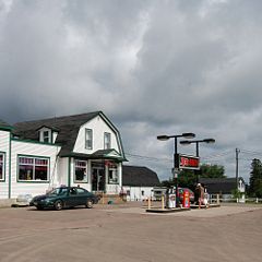
Bass River
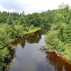
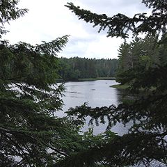
Richibucto River
The Richibucto River is a river in eastern New Brunswick which empties into the Northumberland Strait north of Richibucto, New Brunswick. It is 80 kilometres long.The river's name means "river of fire" in the Mi'kmaq language....
. In 1871 Bass River had a population of 400, in 1898 Bass River had 1 post office, 3 stores, 1 grist mill, 2 churches and a population of 350.
Bass River is home of the Bass River County Fair held annually on July 12 weekend since 1974. The week long celebration of local English, Irish and Scot's heritage has featured events such as the double horse haul, a parade, horse and car shows, circus rides and games for family and children as well as providing top notch New Brunswick musical entertainment from artists such as Kevin Chase and Don Coleman. A weekend regular at Bass River Country Club is country music singer and songwriter, Valerie Thompson with Heartland who makes her home in Bass River and the community is also home to a rock and roll band named Cactus Tung, once featured on the New Brunswick Music website. The community center hosts a softball field, outdoor skating rink, horse show display spaces and barn, picnic area, playground equipment and open spaces available for the communities enjoyment.
Thompson's General Store in Bass River has a long-standing history, conveniently located along Route 116 and currently owned by Glen Thompson of GlenHar Builders Ltd., Quispamsis, New Brunswick. Glen was raised in Bass River and the Thompson family of Northern Ireland with Scottish roots has long standing roots in the community with a Road from St. Mark's Presbyterian Church to Mrs. Thompson's constructed in 1854. The church, near Walker's Mill, a thriving business in the 1880s, was constructed about the year 1840 and was the center of community living for early settlers to the area including surnames Campbell, Walker, Stewart, McKendrick and McDougall.
The general store in Bass River was at one time owned by the ancestors of Major John McKendrick Hughes, 1882–1967, with The 151st Battalion Company: C and honoured for his work with French civilians while serving as an Agricultural Officer in the fall of 1917. Major Hughes was made an Officier l'Ordre du merite agricole, one of four Canadian officers to receive this French award. His accomplishments are highlighted in a book which describes his experience and service with the Armistice Commission. The book was written by his grandson, John R. Hughes, based on letters the Officer sent home from the field to his wife Sarah which were compiled and published in May 2005, University of Alberta Press, 'The Unwanted, Great War Letters from the Field'. Major Hughes was descendant from Donald McKendrick and Catherine Little who are noted on the land grant map at Bass River having moved to the area about 1810 from Prince Edward Island where the family had originally settled after immigration from Scotland in 1770.
Krista Betts is a Canadian Women's Wrestling Gold Medal Winner and recipient of the 2005 Roland McLenahan Award, given to New Brunswick Athletes who best combine excellence in sport, perseverance and sportsmanship and who has made a significant contribution to the New Brunswick team effort at the Canada Games. In 2005, Krista Betts made Canada Games
Canada Games
The Canada Games is a high-level multi-sport event with a National Artists Program held every two years in Canada, alternating between the Canada Winter Games and the Canada Summer Games. Athletes are strictly amateur only, and represent their province or territory.The Games were first held in 1967...
history by becoming the first gold medal winner for women's wrestling at the Canada Games, she led Team NB at the closing ceremonies and was also New Brunswick's flag bearer. Betts wrestled in the 2009 Romanian International Junior Cup which took place in Resita Romania on May 19–22 and won against Disislava Kuncheva(Bulgaria) 2-0, 7-0, she beat Ileana Dobrescu(Romania) win 6-0, 7-3 in the final match to win gold. The whole week before the tournament Krista along with the rest of the Canadian National Team had a training camp in Resita and after the tournament was over they traveled to Schifferstadt, Germany for another training camp and practiced at one of the sport schools there. Unfortunately, Betts was hurt during the week, suffering a costochondral separation and was unable to compete in the tournament in Dormagen, Germany that weekend. After attending physiotherapy her next trip was to Guelph, Ontario, Canada for a training camp in preparation for the World Junior Championships held in Turkey.
Bass River is very proud of all our local sports heroes including the Bass River Rednecks, New Brunswick Softball Champions.
Other local businesses in 2010 include some specializing in New Brunswick Hunting Adventures such as Upriver Outfitters.
Bass River Point
Bass River Point is a community in Weldford located 4.25 km ESE of Molus River and had a Post Office from 1915-1956. Today the area is home to the largest farming operations remaining in the community and one of the largest in New Brunswick, Shipyard Farms. Bass River Point is a popular spot for trout fishing and enjoying country living.Latitude : 46° 33' Longitude : 65° 2'
Beersville
Beersville is a small community located 3.92 km SSE of Fords Mill and was named for John A. Beers (1860–1951) The community had a Post Office from 1900–1965 and in 1904 Beersville was a station on the Intercolonial Railway and a farming settlement with 1 post office, 1 store, 1 sawmill, 1 church and a population of 100. At one point it was a part of Emerson, at another, Emerson was a separate community but the place name was removed and the name is now honoured in the area by a road through Beersville called Emerson Road. Emerson was possibly named for Henry Robert Emerson (1853–1914), the Premier of New Brunswick from 1897–1900 and in 1904 Emerson was a farming settlement with 1 post office.Beersville has a local community center and was home of the local Fire Department for many years before moving to nearby Fords Mills.
Latitude : 46° 27' Longitude : 65° 5'
Browns Yard
Browns Yard is a community in the Local Service District of Weldford located 4.5 km NE of Fords Mill and was once called Upper Main River, with a Post Office from 1909-1956. This community is home to a picturesque view of our picture province that was once unmatched in the province, complete with an old covered bridge at the bottom of hill, an island thick with tall white pines, a church nestled near the shore and at other times this was the site of shipbuilding operations with 7 ships claimed to have been constructed at Browns Yard.The church is St. Paul's Anglican and it features a marvelous old cemetery where some of the earliest settlers to Weldford were buried and the church continues to be the center of family life with activities for children, youth and many family events hosted at their church hall.
Browns Yard is the location of the Annual Fishing Derby with around 200 participants enjoying a day full of family fun with a BBQ and chances to win prizes for the biggest fish and guessing the size of a salmon. The event attracts people from nearby communities of Elsipogtog, Richibucto and Rexton, New Brunswick
Rexton, New Brunswick
Rexton is a Canadian village in Kent County, New Brunswick.Situated on the Richibucto River, the village was originally inhabited by Mi'kmaqs, many of whose descendants still reside in the nearby Elsipogtog First Nation, formerly referred to as the Big Cove Band...
.
Latitude : 46° 31' Longitude : 65° 4'
Bryants Corner
Bryants Corner is a community in Weldford, located 3.83 km E of Harcourt and named for James Bryant, Jabez Bryant, William Bryant Jr. and Annie Bryant who were early settlers bringing the Methodist religion to the community with the formation of the Gospel Hall. There was a Post Office from 1912–1964 and it included Colebrookdale, a former name for the community of Coal Branch.Latitude : 46° 28' Longitude : 65° 12'
Cails Mills
Cails Mills is a community in the Local Service District of Weldford, located 4.26 km ENE of Bryants Corner and 3.83 km W of Fords Mill. It had a Post Office from 1912–1964 with Jonathan Cail as first postmaster. The community was named for the family of Anthony Cail who had a mill near the mouth of the Coal Branch River and were among the earliest settlers of the community to arrive from England.Latitude : 46° 29' Longitude : 65° 9'
Coal Branch
Coal Branch is an unincorporated community in the Local Service Districts of both Weldford and Harcourt that grew up around the Coal Branch River, a smaller tributary of the Richibucto River Estuary. The community of Coal Branch is located 4.51 km NW of Birch Ridge, on the road to Adamsville, Harcourt Parish, Kent County, and in 1898 it was a farming and lumbering community with 2 stores, 1 sawmill, 1 grist mill, 3 churches and a population of 500. There was a Post Office at Coal Branch Station 1877-1970 and in 1898 Coal Branch was a station on the Intercolonial Railway and a farming and lumbering settlement with 1 post office, 1 store and a population of 100.The Coal Branch River was once the site of coal mining operations with the Beersville Coal and Railway Company. The community also has a community center, softball field and local churches.
Latitude : 46° 21' Longitude : 65° 9' County : Kent Parish : Harcourt
Latitude : 46° 29' Longitude : 65° 6' County : Kent Parish : Weldford
Clairville
Clairville is a community in the Local Service District of Weldford, located 5.34 km NE of Coal Branch, on the road to Jailletville. It was once called Hawk Ridge or New Lorne Settlement and some claim it was renamed Clairville for an early settler, Clairville Price who was a Post Master there 1905-1958, however, others believe it may have been named for the McLeary family who originally came from Scotland and settled in that location.Latitude : 46° 23' Longitude : 65° 6'
East Branch
East Branch is a community in the Local Service District of Weldford that was named for the east branch of St. Nicholas River and is located 2.55 km E of South Branch and in 1898 this was a farming and lumbering settlement with 1 sawmill and a population of 75.Latitude : 46° 32' Longitude : 64° 53'
Ford's Mills
Ford's Mills is a settlement in Weldford, New Brunswick named for JOHN PRALL FORD, born August 1, 1789 at Hammond River, Kings County, New Brunswick, who died suddenly on August 2, 1869 at Hammond River, New Brunswick at age 80 years, burial at St. Paul's Church of England, Hampton, New Brunswick. He married PHOEBE TOWNSEND, she died March 24, 1887, age 95, at Coal Branch, Kent County, New Brunswick. He was son of CAPTAIN JOHN FORD, born 1746 who died in 1823 and was an Officer with the New Jersey Volunteers and married to ALCHA PRALL of Dutch ancestry. Mr. J. P. Ford, formerly of Halifax, built the Fords Mill on the Richibucto River about the year 1825.Ford's Mills in 2010 is home of The Greenwood Lodge which hosts, community suppers and excellent musical entertainment including some well known Maritime Musicians such as Matt Minglewood. The local ambulance and fire protection services are located in this community. Fords Mill is located 3.83 km E of Cails Mills and was first called Coal Branch. There was a Post Office in Coal Branch from 1868–1883 and in 1871 Coal Branch had a population of 200. The community was renamed Ford's Mills in 1883 and had a Post Office from 1883-1966. In 1904 Ford's Mills was a lumbering settlement with 2 stores, 1 sawmill, 1 grist mill and a population of 150.
Daniel F. Johnson's New Brunswick Newspaper Transcripts at Provincial Archives New Brunswick - "August 4, 1869 County : Saint John Place : Saint John Newspaper : Morning News John P. FORD, Esq., nearly 80 years old, resident of Kings Co. suddenly dropped dead just outside his house at Hammond River, Monday morn., directly after taking his breakfast."
Jailletville
Jailletville is a community in the Local Service District of Weldford located 5.33 km SE of Beersville and was first called Girvan Settlement for Albert Girvan, Russel Girvan and Samuel Girvan, who were early settlers here. It was renamed Jailletville with the creation of the post office 1906-1958 with Charles F. Jaillet as first postmaster. The community of Ford Bank located 2.25 km NW of Normandie, had a Post Office 1917-1960 but the area is now considered a part of Jailletville as is the area known as Pine Ridge which is located 3.83 km E of Fords Mill, on the road to Ford Bank and it one time included the community of Girvan Settlement.Girvan Settlement had a Post Office 1871-1874, Pine Ridge had a Post Office 1874-1959: and in 1898 Pine Ridge was a farming settlement with 1 post office and a population of 150. Today the old Girvan Farm is the home of The Green Festival, an annual celebration of family and green energy and a weekend music festival with camping.
Jailletville - Latitude : 46° 25' Longitude : 65° 2'
Pine Ridge - Latitude : 46° 29' Longitude : 65° 3'
Ford Bank - Latitude : 46° 30' Longitude : 65° 0'
Kent Junction
Kent Junction is a community in the Local Service District of Weldford located 6.64 km WSW of Saint-Joseph and had a Post Office 1884-1891 and 1894-1970. In 1898 Kent Junction was a station on the Intercolonial Railway and a farming and lumbering settlement with 1 post office, 1 store, 1 hotel and a population of 75. Today it is home to a community center called Kent Lake Lodge and is home to Acadian families living near the border with Rogersville, New BrunswickRogersville, New Brunswick
Rogersville is a Canadian village in Northumberland County, New Brunswick.Rogersville is the home of two Trappist monasteries, Notre-Dame de l'Assomption Abbey and Notre Dame du Calvaire Abbey...
.
Kent Junction Latitude : 46° 35' Longitude : 65° 20'
Saint-Joseph is a community in the Local Service District of Weldford, located 6.63 km ENE of Kent Junction that had a Post Office Village-Saint-Joseph 1923-1927. the community is generally considered a part of the Kent Junction area and is home to Acadian families.
Saint-Joseph - Latitude : 46° 36' Longitude : 65° 15'
Lower Main River
Lower Main River is an unincorporated community in the Local Service District of Weldford located on the south side of Richibucto River 4.5 km North West of West Branch on the road to Mundleville.Canadian Post Office History indicates there was a Post Office in Main River 1875-1877 and 1883-1956. In 1898 Main River was a farming and lumbering settlement with 1 post office, 1 church and a population of about 200. The community name is sometimes used to indicate the main section of the Richibucto River, however, A History and Story of Botsford, a Parish of Westmorland County, New Brunswick, Canada, with genealogical sketches of 68 families by W. M. BURNS, indicates a Mr. David Main with his two sons immigrated to New Brunswick in 1821 and settled near Rexton, Kent County and the place where they operated a cedar mill along the Richibucto River became known as Main River.
Main River is the ancestral home of Alan R. Graham, long serving MLA for Kent County, New Brunswick and his son Shawn Graham
Shawn Graham
Shawn Michael Graham, MLA is a New Brunswick politician, who served as the 31st Premier of New Brunswick. He received a Bachelor of Physical Education Degree in 1991 and a Bachelor of Education Degree in 1993, he worked for New Brunswick's civil service before being elected to the Legislative...
Premier of New Brunswick.
Latitude : 46° 34' Longitude : 64° 59'
Molus River
Molus River had a Post Office and was named Moulies River 1867-1950 and Molus River ????-1867, 1950-present. In the year 1871 Molus River had a population of 150. In 1898 Molus River was a farming, fishing and lumbering settlement with 1 post office, 1 General Store, 1 school, 1 Lodging House, 1 church and a population of 300; and a High Tide Warf. In 1901 Molus River had 2 stops along the Kent Northern Railway. The community of Molus River today, is moving from a farming and forestry community to becoming a great place for a cottage and enjoying a quiet day in the canoe. With old farming a logging roads making a network of trails ideal for hiking, horseback riding, snow-mobiling, and other recreational activities. Epsikitiáskuk is what the Mi’kmaq people of Elsipogtog First Nation called the Molus River as seen on old land grant documents at Provincial Archives New Brunswick. A loose translation would be "River at the edge." A possible source for the word Molus is from the French language spoken by Acadians living around nearby Richibucto, with the word “moluёs” being a French word for a tidal flat mussel, a type of shellfish commonly found on the muddy beaches along the river.
Land Grants at Provincial Archives New Brunswick indicate that in 1819 Molus River was "at the center of the Indian Reserve" when it was opened to British subjects for settlement. The primary reason for settlement was to obtain the large-old growth White Pines, and other trees for the Ship-building happening down River at "Kingston" now Rexton and Jardineville. The first European settlers of the south side of the Molus River were in 1821 with Thomas Phelan (Whalen), John Phelan, Patrick Phelan. By the 1830s the north side was also opened and the Warman family settled here. Other settler names: Olsen, Dargavel, Stevenson, Millar, McPherson, Ward, and Harnett. The community reached its height in the late 1800s and by 1901 the community had 2 stops on the Kent Northern Railway but settlement began to decline after the virgin forests of white pine and maple had been stripped from the land to supply the shipbuilding industry and the local economy become more dependant on agriculture.
For a period from about 1850-1900 the name on maps was often spelled Moulies River and moulies is a type of coal shale that was harvested during the days of coal mining operations along the Coal Branch River and there is also an old, oral tradition that the river may have been named for a Henry Molus, an early settler living near the river.
Mundleville
Mundleville is a community in the Local Service District of Weldford located at the confluence of the Richibucto River and the St. Nicholas River, and had a Post Office 1899-1956. In 1904 Mundleville was a farming settlement with 1 post office, 1 store, 1 church and a population of 125. Today the community features some of the most beautiful homes along the Richibucto River, has a few small businesses and hosts an Annual Winter Carnival.Latitude : 46° 35' Longitude : 64° 55'
Saint-Norbert
Saint-Norbert is a community in the Local Service District of Weldford, located 2.25 km SE of Normandie. There was a Post Office 1881-1970 and it was established about 1850 as Louisbourg: formerly called Boucher Settlement for Eusèbe Boucher, Joseph Boucher and Antoine Boucher, who were early settlers in the area and in 1898 Saint-Norbert was a farming and lumbering settlement with 1 post office, 2 stores, 1 church and a population of 200.Saint-Norbert - Latitude : 46° 28' Longitude : 64° 58'
Normandie is a community in the Local Service District of Weldford, located 2.25 km NW of Saint-Norbert, on the road to Ford Bank and was named for the French province of Normandie. It had a Post Office 1914-1958 but is generally considered part of St. Norbert.
Normandie - Latitude : 46° 29' Longitude : 64° 59'
Smiths Corner
Smiths Corner is a community in the Local Service District of Weldford located on the Richibucto River, 6.75 km SW of Bass River, on Route 116 to Harcourt and had a Post Office 1893-1959. In 1898 Smiths Corner was a farming and lumbering settlement with a population of 100. Today this is a popular spot for smelt fishing and is at the end of the canoe run along the Mortimer River, the local name for that portion of the Richibucto River that runs along Route 116. This community has been home to The Good Life Gathering, a multi-cultural, outdoor experience for youth hosted by Willi Nolan, a community member active with the Sierra Club of Canada.Smiths Corner - Latitude : 46° 30' Longitude : 65° 10'
South Branch
South Branch is a community in the Local Service District of Weldford located on the St. Nicholas River, 2.55 km E of West Branch and it had a Post Office 1873-1960. In 1898 South Branch was a farming and lumbering settlement with 1 post office, 1 sawmill, 1 grist mill, 1 church and a population of 400. The community was also known as Warrens Mills for Thomas W. Warren (1896–1971) and old photographs at Provincial Archives New Brunswick show photos of this old mill. The Warren Family went on to found Warren's Ready Mix, a company now in Rexton.South Branch - Latitude : 46° 32' Longitude : 64° 55'
Targettville
Targettville is a community in the Local Service District of Weldford, located on the Richibucto River, 7.55 km NE of Fords Mill, on the road to Browns Yard. This community had a Post Office 1928-1956 and was site of the Targettville Quarry, an operation to extract stone works along the river and move them to Richibucto to construct the break water for that harbour. Today the community has a popular outdoor skating rink and recreation center with an outdoor playground and a room for the Local CAL-Net Center. The facility holds community events such as music nights and family re-unions as well as having a very active program for young children during the summer.Targettville - Latitude : 46° 32' Longitude : 65° 2'
Village St. Augustine
Village St. Augustine is a small community in the Local Service District of Weldford located 3.16 km NE of Adamsville, on the road to Beersville. It is included in both Harcourt and Weldford and had a Post Office 1912-1951. At one time it included the settlement of Adamsville East, now in the Parish of Harcourt, the area is now home to a few Acadian families.Village St. Augustine - Latitude : 46° 25' Longitude : 65° 9'
West Branch
West Branch is a community in the Local Service District of Weldford located on the West side of St. Nicholas River, 6.12 km SSW of Mundleville, on the road to Ford Bank. It had a Post Office 1867-1956 and in 1871 had a population of 200, in 1898 West Branch was a farming and lumbering village with 1 post office, 1 store, 2 churches and a population of 500. Stories about the early settlers to West Branch are recorded in a book called West Branch Days by Eleanor Wilson Graham whose name is also honoured at the local middle school in Rexton where the students from the Weldford area attend school. West Branch was settled by families from Scotland including surnames Morton and Wilson.West Branch - Latitude : 46° 32' Longitude : 64° 57'
Population
Population trend| Census | Population | Change (%) |
|---|---|---|
| 2006 | 1,426 | 2.8% |
| 2001 | 1,467 | 6.0% |
| 1996 | 1,561 | 0.1% |
| 1991 | 1,560 | N/A |
Language
Mother tongue language (2006)| Language | Population | Pct (%) |
|---|---|---|
| English only | 1,175 | 82.17% |
| French only | 230 | 16.08% |
| Other languages | 15 | 1.05% |
| Both English and French | 10 | 0.70% |
External links
- New Brunswick Provincial Archives - Weldford Parish
- Softball New Brunswick Championship Results
- Richibucto River Association
- Kent County Gen web
- West Branch Days featured on Ruby Cusack
- Eleanor Wilson Graham Middle School
- The Green Festival
- Biography Willi Nolan
- Krista Betts receives Award
- Wild Heart of Kent