

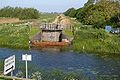
Welches Dam
Encyclopedia
Cambridgeshire
Cambridgeshire is a county in England, bordering Lincolnshire to the north, Norfolk to the northeast, Suffolk to the east, Essex and Hertfordshire to the south, and Bedfordshire and Northamptonshire to the west...
around 5 miles (8 km) to the north west of Ely
Ely, Cambridgeshire
Ely is a cathedral city in Cambridgeshire, England, 14 miles north-northeast of Cambridge and about by road from London. It is built on a Lower Greensand island, which at a maximum elevation of is the highest land in the Fens...
. It covers an area of 2355 acres (953 ha).
The parish of Welches Dam is surrounded by those of Coveney
Coveney, Cambridgeshire
Coveney is a village north of Cambridge in Cambridgeshire. Several bronze axes have been found here, shields and a few swords, all dating from the late Bronze Age. Coveney is on a small 'island' rising to above sea level, some west of Ely city as the crow flies, but nearly twice that distance by...
, Manea
Manea, Cambridgeshire
Manea is a village in the District of Fenland, Cambridgeshire, England. It is an expanding village in the Cambridgeshire Fens. Notable features are Manea railway station and RSPB Welches Dam nature reserve on the Ouse Washes...
, Mepal
Mepal
Mepal is a village in Cambridgeshire, England. Mepal is part of the East Cambridgeshire district, and is located just north of the A142 road between Ely and Chatteris.-History:...
, and Witcham
Witcham
Witcham is a small village near Ely in Cambridgeshire, England.The village is surrounded by fenland farms and has a village hall and a 13th-century church dedicated to St Martin. It has a pub called the White Horse, which was the winner of the Ely and District CAMRA Rural Pub of the Year Award...
. The civil parish was divided between Chatteris
Chatteris
Chatteris is a civil parish and one of four market towns in the Fenland district of Cambridgeshire, England, situated in The Fens between Huntingdon, March and Ely...
and Manea in 1960.
History
The history of the parish is tied to that of The FensThe Fens
The Fens, also known as the , are a naturally marshy region in eastern England. Most of the fens were drained several centuries ago, resulting in a flat, damp, low-lying agricultural region....
and the battle to drain it in the first half of the 17th century. The original principal drainage channel for the area, the Old Bedford River
Old Bedford River
The Old Bedford River is an artificial, partial diversion of the waters of the River Great Ouse in the Fens of Cambridgeshire, England. It was named after the fourth Earl of Bedford who contracted with the local Commission of Sewers to drain the Great Level of the Fens beginning in 1630.The idea of...
, runs through the parish.
The parish's name derives from Edward Welsh who built a dam across the Bedford River. Welsh was an employee of the Adventurers, the 17th century entrepreneurs who invested in the results of Vermuyden
Cornelius Vermuyden
Sir Cornelius Wasterdyk Vermuyden was a Dutch engineer who introduced Dutch reclamation methods to Britain, and made the first important attempts to drain The Fens of East Anglia.-Life:...
's efforts to drain the fens.
Fortrey's Hall, the 17th century ancestral seat of the Fortrey family lies in the parish.
In 1849, the area became infamous after 11 of the 187 residents of the parish died in an outbreak of cholera
Cholera
Cholera is an infection of the small intestine that is caused by the bacterium Vibrio cholerae. The main symptoms are profuse watery diarrhea and vomiting. Transmission occurs primarily by drinking or eating water or food that has been contaminated by the diarrhea of an infected person or the feces...
.