
Washington State Route 221
Encyclopedia
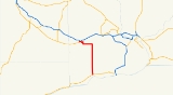
State Route 221 is a 25.95 miles (41.8 km) long state highway
located entirely with in Benton County
, Washington, United States. The highway serves to connect the unincorporated community
of Paterson
to the county seat
Prosser
. The highway has existed since at least 1926 as Primary State Highway 8E until the 1964 renumbering of Washington state highways.
, gaining a passing lane through the uphill segments, before finally terminating at SR 22 in south Prosser
.
Every year the Washington State Department of Transportation
(WSDOT) conducts a series of surveys on its highways in the state to measure traffic volume. This is expressed in terms of average annual daily traffic (AADT), which is a measure of traffic volume for any average day of the year. In 2009, WSDOT calculated that as few as 2,000 cars traveled through the central part of the highway, and as many as 2,500 cars at the interchange with SR 22.
.
High winds have forced the closure of SR 221 in 2003, 2004, and 2005 due to large amounts of dust being blown around, causing visibility to drop to almost zero through the Horse Heaven Hills.
.
{| class="wikitable"
|-
!scope=col|Mile
!scope=col|Destinations
!scope=col|Notes
|-
|0.00
|
|At-grade intersection
, southern terminus
|-
|25.95
|
|At-grade intersection, northern terminus
|-
State highway
State highway, state road or state route can refer to one of three related concepts, two of them related to a state or provincial government in a country that is divided into states or provinces :#A...
located entirely with in Benton County
Benton County, Washington
Benton County is a county located in the south-central portion of the U.S. state of Washington. The Columbia River makes up the north, south, and east boundaries of the county. In 2010, its population was 175,177. The county seat is Prosser, and its largest city is Kennewick...
, Washington, United States. The highway serves to connect the unincorporated community
Unincorporated area
In law, an unincorporated area is a region of land that is not a part of any municipality.To "incorporate" in this context means to form a municipal corporation, a city, town, or village with its own government. An unincorporated community is usually not subject to or taxed by a municipal government...
of Paterson
Paterson, Washington
Paterson is an unincorporated community in Benton County, Washington, United States, located on the northern banks of the Columbia River at the junction of Washington State Route 14 and Washington State Route 221. It was named for early settler Henry Patterson....
to the county seat
County seat
A county seat is an administrative center, or seat of government, for a county or civil parish. The term is primarily used in the United States....
Prosser
Prosser, Washington
Prosser is a city in and the county seat of Benton County, Washington, United States, along the Yakima River with only one zip code 99350. The population was 5,714 at the 2010 census.-History:...
. The highway has existed since at least 1926 as Primary State Highway 8E until the 1964 renumbering of Washington state highways.
Route description
Washington State Route 221 (SR 221) starts at an intersection with SR 14 in the unincorporated community of aterson. After leaving Paterson the highway travels north through rural farm land as a two-lane highway. A few minor roads are intersected before the roadway turns to the west after about 17 mi (27.4 km), before turning back to the north. After the highway resumes its northerly course it climbs into the Horse Heaven HillsHorse Heaven Hills
The Horse Heaven Hills are a long range of high, rolling hills in Klickitat, Yakima, and Benton counties in Washington State located east of Satus Creek and west of the Columbia River between the Yakima River and the Wallula Gap. The hills are an anticline ridge in the Yakima fold belt formed by...
, gaining a passing lane through the uphill segments, before finally terminating at SR 22 in south Prosser
Prosser, Washington
Prosser is a city in and the county seat of Benton County, Washington, United States, along the Yakima River with only one zip code 99350. The population was 5,714 at the 2010 census.-History:...
.
Every year the Washington State Department of Transportation
Washington State Department of Transportation
The Washington State Department of Transportation , was established in 1905. The agency, led by a Secretary and overseen by the Governor, is a Washington governmental agency that constructs, maintains, and regulates the use of the state's transportation infrastructure...
(WSDOT) conducts a series of surveys on its highways in the state to measure traffic volume. This is expressed in terms of average annual daily traffic (AADT), which is a measure of traffic volume for any average day of the year. In 2009, WSDOT calculated that as few as 2,000 cars traveled through the central part of the highway, and as many as 2,500 cars at the interchange with SR 22.
History
The roadway on its current alignment has existed since at least 1926, however there are records of a road between Paterson and Prosser since 1906. The highway was designated Secondary State Highway 8E (SSH 8E) since at least 1937, but the route number was changed during the 1964 state highway renumbering1964 state highway renumbering (Washington)
In 1963, a law was passed authorizing a new numbering for sign routes. In 1970 the legislative definitions were changed to use the sign route numbers but renamed state routes...
.
High winds have forced the closure of SR 221 in 2003, 2004, and 2005 due to large amounts of dust being blown around, causing visibility to drop to almost zero through the Horse Heaven Hills.
Major intersections
The entire route is with in unincorporated Benton CountyBenton County, Washington
Benton County is a county located in the south-central portion of the U.S. state of Washington. The Columbia River makes up the north, south, and east boundaries of the county. In 2010, its population was 175,177. The county seat is Prosser, and its largest city is Kennewick...
.
{| class="wikitable"
|-
!scope=col|Mile
!scope=col|Destinations
!scope=col|Notes
|-
|0.00
|
|At-grade intersection
At-grade intersection
An at-grade intersection is a junction at which two or more transport axes cross at the same level .-Traffic management:With areas of high or fast traffic, an at-grade intersection normally requires a traffic control device such as a stop sign, traffic light or railway signal to manage conflicting...
, southern terminus
|-
|25.95
|
|At-grade intersection, northern terminus
|-