
Washington State Route 220
Encyclopedia
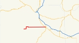
State Route 220 was a 27.42 miles (44.1 km) long state highway
located entirely in the Yakama Indian Reservation
, Yakima County
, Washington, United States. The highway linked Fort Simcoe State Park in the west to White Swan
and Toppenish
in the east. The highway had been built sometime between 1915 and 1937, and was renumbered from Secondary State Highway 3B during the 1964 state highway renumbering
. The route was slated to be removed from the state highway system during the 1991 legislative session, and was removed April 1, 1992.
rail line, formerly part of the Toppenish, Simcoe & Western Railroad, before Curtis street turned easterly and became Fort Road. Fort Road continued almost perfectly east for about 18 mi (29 km) before intersecting US Route 97
(US 97). After crossing US 97, the highway continued as a city street through west Toppenish
before terminating at SR 22.
Every year the Washington State Department of Transportation
(WSDOT) conducts a series of surveys on its highways in the state to measure traffic volume. This is expressed in terms of average annual daily traffic (AADT), which is a measure of traffic volume for any average day of the year. In 1991, WSDOT calculated that as few as 340 cars used the highway at the western terminus and as many as 9,300 cars at the interchange with SR 22.
when the SR 220 number was applied to the highway. The original eastern terminus was US 97, but in 1971 the terminus was extended to SR 22. The highway was de-legislated in 1991 along with eleven other highways, and was removed from the system effective April 1, 1992.
 The entire route was entirely in the Yakama Indian Reservation
in Yakima County, Washington
.
{| class="wikitable"
|-
|scope=col|Location
!scope=col|Mile
!scope=col|Destinations
!scope=col|Notes
|-
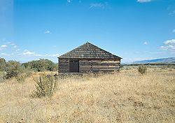
|Fort Simcoe
|0.00
| Fort Simcoe State Park
|At-grade intersection
, western terminus
|-
|
|26.96–27.01
|
|
|-
|Toppenish
|27.42
|
||At-grade intersection, eastern terminus
|-
State highway
State highway, state road or state route can refer to one of three related concepts, two of them related to a state or provincial government in a country that is divided into states or provinces :#A...
located entirely in the Yakama Indian Reservation
Yakama Indian Reservation
The Yakama Indian Reservation is a United States Indian reservation located on the east side of the Cascade Mountains in southern Washington. It is the homeland of the Yakama tribe of Native Americans....
, Yakima County
Yakima County, Washington
Yakima County is the second largest county by area in the U.S. state of Washington. It is named after the Yakama tribe of Native Americans. In the 2010 census, its population was 243,231...
, Washington, United States. The highway linked Fort Simcoe State Park in the west to White Swan
White Swan, Washington
White Swan is a census-designated place in Yakima County, Washington, United States. The population was 793 at the 2010 census. This was a 73.9% drop from the 2000 census.-History:...
and Toppenish
Toppenish, Washington
Toppenish is a city in Yakima County, Washington, in the United States. As of the 2010 census, the city population was 8,949.-History:The General Allotment Act of 1887 granted an allotment of land to a woman of half Indian ancestry, Josephine Bowser Lillie, known as "The Mother of Toppenish"...
in the east. The highway had been built sometime between 1915 and 1937, and was renumbered from Secondary State Highway 3B during the 1964 state highway renumbering
1964 state highway renumbering (Washington)
In 1963, a law was passed authorizing a new numbering for sign routes. In 1970 the legislative definitions were changed to use the sign route numbers but renamed state routes...
. The route was slated to be removed from the state highway system during the 1991 legislative session, and was removed April 1, 1992.
Route description
SR 220 started at Fort Simcoe State Park, headed easterly along Fort Simcoe Road until it intersected Hawk Road. At the t intersection with Hawk Road, the highway turned north and follows Hawk Road until an intersection with White Swan Road. The highway turned back east along White Swan Road, passing through downtown White Swan, before turning south along Curtis Street. The highway passed over a BNSF RailwayBNSF Railway
The BNSF Railway is a wholly owned subsidiary of Berkshire Hathaway Inc., and is headquartered in Fort Worth, Texas. It is one of seven North American Class I railroads and the second largest freight railroad network in North America, second only to the Union Pacific Railroad, its primary...
rail line, formerly part of the Toppenish, Simcoe & Western Railroad, before Curtis street turned easterly and became Fort Road. Fort Road continued almost perfectly east for about 18 mi (29 km) before intersecting US Route 97
U.S. Route 97 in Washington
In the U.S. state of Washington, U.S. Route 97 is a route which traverses from the Oregon state line at the northern end of the Sam Hill Memorial Bridge in Maryhill, north to the Canadian border in Okanogan County near Oroville...
(US 97). After crossing US 97, the highway continued as a city street through west Toppenish
Toppenish, Washington
Toppenish is a city in Yakima County, Washington, in the United States. As of the 2010 census, the city population was 8,949.-History:The General Allotment Act of 1887 granted an allotment of land to a woman of half Indian ancestry, Josephine Bowser Lillie, known as "The Mother of Toppenish"...
before terminating at SR 22.
Every year the Washington State Department of Transportation
Washington State Department of Transportation
The Washington State Department of Transportation , was established in 1905. The agency, led by a Secretary and overseen by the Governor, is a Washington governmental agency that constructs, maintains, and regulates the use of the state's transportation infrastructure...
(WSDOT) conducts a series of surveys on its highways in the state to measure traffic volume. This is expressed in terms of average annual daily traffic (AADT), which is a measure of traffic volume for any average day of the year. In 1991, WSDOT calculated that as few as 340 cars used the highway at the western terminus and as many as 9,300 cars at the interchange with SR 22.
History
The highway was first constructed some time between 1915 and 1937, with a segment linking Fort Simcoe to White Swan completed by 1937. The highway was signed as Secondary State Highway 3B (SSH 3B) between White Swan and Toppenish until the 1964 state highway renumbering1964 state highway renumbering (Washington)
In 1963, a law was passed authorizing a new numbering for sign routes. In 1970 the legislative definitions were changed to use the sign route numbers but renamed state routes...
when the SR 220 number was applied to the highway. The original eastern terminus was US 97, but in 1971 the terminus was extended to SR 22. The highway was de-legislated in 1991 along with eleven other highways, and was removed from the system effective April 1, 1992.
Today
All of the roads that SR 220 were routed along are still accessible, and have been designated major collector roads by WSDOT. The entirety of the former routing of SR 220 has been designated Classified Route S390. The city of Toppinish is eligible to receive hardship funding for the former highway between the junction with SR 22 to near Linden Road, a span of 0.27 mi (434.5 m).Major intersections
Yakama Indian Reservation
The Yakama Indian Reservation is a United States Indian reservation located on the east side of the Cascade Mountains in southern Washington. It is the homeland of the Yakama tribe of Native Americans....
in Yakima County, Washington
Yakima County, Washington
Yakima County is the second largest county by area in the U.S. state of Washington. It is named after the Yakama tribe of Native Americans. In the 2010 census, its population was 243,231...
.
{| class="wikitable"
|-
|scope=col|Location
!scope=col|Mile
!scope=col|Destinations
!scope=col|Notes
|-
|Fort Simcoe
Fort Simcoe
Fort Simcoe was a United States Army fort erected in south-central Washington Territory to house troops sent to keep watch over local Indian tribes...
|0.00
|
|At-grade intersection
At-grade intersection
An at-grade intersection is a junction at which two or more transport axes cross at the same level .-Traffic management:With areas of high or fast traffic, an at-grade intersection normally requires a traffic control device such as a stop sign, traffic light or railway signal to manage conflicting...
, western terminus
|-
|
|26.96–27.01
|
|
|-
|Toppenish
Toppenish, Washington
Toppenish is a city in Yakima County, Washington, in the United States. As of the 2010 census, the city population was 8,949.-History:The General Allotment Act of 1887 granted an allotment of land to a woman of half Indian ancestry, Josephine Bowser Lillie, known as "The Mother of Toppenish"...
|27.42
|
||At-grade intersection, eastern terminus
|-