

Wallasea Island
Encyclopedia
Essex
Essex is a ceremonial and non-metropolitan county in the East region of England, and one of the home counties. It is located to the northeast of Greater London. It borders with Cambridgeshire and Suffolk to the north, Hertfordshire to the west, Kent to the South and London to the south west...
, England
England
England is a country that is part of the United Kingdom. It shares land borders with Scotland to the north and Wales to the west; the Irish Sea is to the north west, the Celtic Sea to the south west, with the North Sea to the east and the English Channel to the south separating it from continental...
. It is bounded to the north by the River Crouch
River Crouch
The River Crouch is a river that flows entirely through the English county of Essex.The distance of the Navigation between Holliwell Point which is north of Foulness Island and Battlesbridge is 17.5 Miles, i.e. 15.21 Nautical Miles.-Route:...
, to the south east by the River Roach
River Roach
The River Roach is a river that flows entirely through the English county of Essex. It flows through the town of Rochford and joins the River Crouch at Wallasea Island.thumb|right|River Roach flowing through Rochford Hundred Golf Course...
, and to the west by Paglesham Pool and the narrow Paglesham Creek.
Much of the island is farmland, and wheat is the main crop. A small settlement at its western end is linked by road to the mainland and is home to a campsite
Campsite
A campsite or camping pitch is a place used for overnight stay in the outdoors. In British English a campsite is an area, usually divided into a number of pitches, where people can camp overnight using tents or camper vans or caravans; this British English use of the word is synonymous with the...
and marina
Marina
A marina is a dock or basin with moorings and supplies for yachts and small boats.A marina differs from a port in that a marina does not handle large passenger ships or cargo from freighters....
. It is linked by a ferry
Ferry
A ferry is a form of transportation, usually a boat, but sometimes a ship, used to carry primarily passengers, and sometimes vehicles and cargo as well, across a body of water. Most ferries operate on regular, frequent, return services...
to Burnham-on-Crouch
Burnham-on-Crouch
Burnham-on-Crouch is a town in the Maldon district of Essex in the East of England. It lies on the north bank of the River Crouch.-History:Historically, it has benefited from its location on the coast - first as a ferry port, later as a fishing port known for its oyster beds, and most recently as a...
.
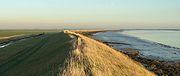
It is possible to walk for about 8 miles around most (but not all) of the sea wall. The south side of the island is one of the most tranquil places in Essex. Here you can see wildlife typical of open farmland such as skylarks, corn buntings and hares. Not far away, on the opposite side of the estuary of the River Roach, you can see Foulness Island and Potton Island.
History
Almost nothing is known about the early history of Wallasea. At the end of the last Ice Age it was almost certainly dry land like most of the North Sea basin. Rising sea levels are thought to have deposited the silt and sand which (together with older clays) underlie the island's soil. Several archaeological features have been recorded on the south and east edges of the island, these are the "red hills" typical of the Roman period and were probably relics of a process of extraction of salt from sea water.Thirteenth century records mention several places on Wallasea such as Lower Barn and Sherwoods. It is likely that Wallasea was used for grazing at that time and there may have been some arable land too. The origins of the various farms is unclear, though it is known there was a farmhouse at Grapnells as far back as 1546. Saxton's map of 1576 shows that creeks divided Wallasea into three separate islands, and this is confirmed by Camden's description of 1551.
The population of Wallasea was at its highest in the mid to late 19th century. In 1875 there were 135 inhabitants and there were 13 houses. A school was opened in 1879 and lasted for 20 years. Import of cheap American wheat resulted in an agricultural depression starting in 1875. Most of the island's population left and Wallasea reverted to pasture.
Much of the island was ploughed up in World War 1 when the import of grain was made more difficult by German submarines. Bumper crops of wheat were grown in this period. The island was also under the plough in World War 2.
Over the centuries Wallasea has been flooded in a number of storms. The most catastrophic inundation was in 1953 after which large sections of sea wall had to be rebuilt. The eastern end of the island was one of the last places in the UK to be drained of floodwater.
Wallasea Wetlands
On July 4, 2006, a £7.5 million project to convert part of the island's farmland into mudflats and salt marsh was completed by bulldozing 300m of the sea defence wall, at the points of maximum pressure on the estuaryEstuary
An estuary is a partly enclosed coastal body of water with one or more rivers or streams flowing into it, and with a free connection to the open sea....
. An area of 115 hectares was flooded, which is evolving into wetland, mudflat
Mudflat
Mudflats or mud flats, also known as tidal flats, are coastal wetlands that form when mud is deposited by tides or rivers. They are found in sheltered areas such as bays, bayous, lagoons, and estuaries. Mudflats may be viewed geologically as exposed layers of bay mud, resulting from deposition of...
s, saline lagoon
Lagoon
A lagoon is a body of shallow sea water or brackish water separated from the sea by some form of barrier. The EU's habitat directive defines lagoons as "expanses of shallow coastal salt water, of varying salinity or water volume, wholly or partially separated from the sea by sand banks or shingle,...
s and seven artificial islands. The wetlands are intended to provide winter grounds for wading birds, and ease flood problems on the River Crouch.
In December 2008, the RSPB submitted a planning application to Essex County Council for a £12 million scheme to break open Wallasea's sea walls and turn the farmland into a wetland bird reserve.