
Victory, Saratoga County, New York
Encyclopedia
----
Victory is a village in Saratoga County
, New York
, United States
. The population was 544 at the 2000 census. The village is located in the northeast part of the town of Saratoga
, southwest of and bordering the village of Schuylerville
. Victory is one of the smallest villages in New York.

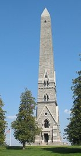
The village was incorporated in 1849. The name Victory is most certainly due to the defeat of the British at the Battles of Saratoga, where Burgoyne surrendered his sword to Gates.
The village has also been called "Victory Mills," likely owing its name to the large (now defunct) factory/mill (Saratoga Victory Manufacturing Company, 1846) centrally located on the primary road through town, Gates Avenue. The US Postal Service refers to the village's ZIP code
as Victory Mills.
The Victory Mills
building was listed on the National Register of Historic Places
on January 19, 2010.
According to the United States Census Bureau
, the village has a total area of 0.5 square miles (1.4 km²), all of it land.
The village is located on the north bank of Fish Creek, a tributary
of the nearby Hudson River
.
New York State Route 32
, Gates Avenue, passes through the village.
of 2000, there were 544 people, 189 households, and 144 families residing in the village. The population density
was 1,030.7 people per square mile (396.3/km²). There were 216 housing units at an average density of 409.2 per square mile (157.4/km²). The racial makeup of the village was 97.61% White, 0.55% African American, 0.37% Native American, and 1.47% from two or more races. Hispanic or Latino of any race were 1.29% of the population.
There were 189 households out of which 46.6% had children under the age of 18 living with them, 54.5% were married couples
living together, 13.8% had a female householder with no husband present, and 23.8% were non-families. 18.5% of all households were made up of individuals and 10.1% had someone living alone who was 65 years of age or older. The average household size was 2.88 and the average family size was 3.19.
In the village the population was spread out with 30.1% under the age of 18, 7.5% from 18 to 24, 32.2% from 25 to 44, 17.3% from 45 to 64, and 12.9% who were 65 years of age or older. The median age was 35 years. For every 100 females there were 95.7 males. For every 100 females age 18 and over, there were 103.2 males.
The median income for a household in the village was $41,250, and the median income for a family was $37,292. Males had a median income of $29,219 versus $22,656 for females. The per capita income
for the village was $17,484. About 10.7% of families and 9.1% of the population were below the poverty line, including 10.8% of those under age 18 and 2.4% of those age 65 or over.
Victory is a village in Saratoga County
Saratoga County, New York
Saratoga County is a county located in the U.S. state of New York. As of the 2010 census, the population was 219,607. It is part of the Albany-Schenectady-Troy Metropolitan Statistical Area. The county seat is Ballston Spa...
, New York
New York
New York is a state in the Northeastern region of the United States. It is the nation's third most populous state. New York is bordered by New Jersey and Pennsylvania to the south, and by Connecticut, Massachusetts and Vermont to the east...
, United States
United States
The United States of America is a federal constitutional republic comprising fifty states and a federal district...
. The population was 544 at the 2000 census. The village is located in the northeast part of the town of Saratoga
Saratoga, New York
Saratoga is a town in Saratoga County, New York, United States. The population was 5,141 at the 2000 census. It is also the commonly used, but not official, name for the neighboring and much more populous city, Saratoga Springs. The major village in the town of Saratoga is Schuylerville which is...
, southwest of and bordering the village of Schuylerville
Schuylerville, New York
Schuylerville is a village in Saratoga County, New York, United States. The population was 1,197 at the 2000 census. The village is named after the Schuyler family....
. Victory is one of the smallest villages in New York.
History
The village was incorporated in 1849. The name Victory is most certainly due to the defeat of the British at the Battles of Saratoga, where Burgoyne surrendered his sword to Gates.
The village has also been called "Victory Mills," likely owing its name to the large (now defunct) factory/mill (Saratoga Victory Manufacturing Company, 1846) centrally located on the primary road through town, Gates Avenue. The US Postal Service refers to the village's ZIP code
ZIP Code
ZIP codes are a system of postal codes used by the United States Postal Service since 1963. The term ZIP, an acronym for Zone Improvement Plan, is properly written in capital letters and was chosen to suggest that the mail travels more efficiently, and therefore more quickly, when senders use the...
as Victory Mills.
The Victory Mills
Victory Mills
Victory Mills is a historic textile mill building located at Victory in Saratoga County, New York. It was built in 1918 by the American Manufacturing Company and is a rectangular, five story brick and reinforced concrete building measuring by . It has about of space. It features six tower...
building was listed on the National Register of Historic Places
National Register of Historic Places
The National Register of Historic Places is the United States government's official list of districts, sites, buildings, structures, and objects deemed worthy of preservation...
on January 19, 2010.
Geography
Victory is located at 43°5′19"N 73°35′37"W (43.088514, -73.593563).According to the United States Census Bureau
United States Census Bureau
The United States Census Bureau is the government agency that is responsible for the United States Census. It also gathers other national demographic and economic data...
, the village has a total area of 0.5 square miles (1.4 km²), all of it land.
The village is located on the north bank of Fish Creek, a tributary
Tributary
A tributary or affluent is a stream or river that flows into a main stem river or a lake. A tributary does not flow directly into a sea or ocean...
of the nearby Hudson River
Hudson River
The Hudson is a river that flows from north to south through eastern New York. The highest official source is at Lake Tear of the Clouds, on the slopes of Mount Marcy in the Adirondack Mountains. The river itself officially begins in Henderson Lake in Newcomb, New York...
.
New York State Route 32
New York State Route 32
New York State Route 32 is a north–south state highway that extends for through the Hudson Valley and Capital District regions of the U.S. state of New York. It is a two-lane surface road for nearly its entire length, with few divided and no limited-access sections. From Harriman to Albany,...
, Gates Avenue, passes through the village.
Demographics
As of the censusCensus
A census is the procedure of systematically acquiring and recording information about the members of a given population. It is a regularly occurring and official count of a particular population. The term is used mostly in connection with national population and housing censuses; other common...
of 2000, there were 544 people, 189 households, and 144 families residing in the village. The population density
Population density
Population density is a measurement of population per unit area or unit volume. It is frequently applied to living organisms, and particularly to humans...
was 1,030.7 people per square mile (396.3/km²). There were 216 housing units at an average density of 409.2 per square mile (157.4/km²). The racial makeup of the village was 97.61% White, 0.55% African American, 0.37% Native American, and 1.47% from two or more races. Hispanic or Latino of any race were 1.29% of the population.
There were 189 households out of which 46.6% had children under the age of 18 living with them, 54.5% were married couples
Marriage
Marriage is a social union or legal contract between people that creates kinship. It is an institution in which interpersonal relationships, usually intimate and sexual, are acknowledged in a variety of ways, depending on the culture or subculture in which it is found...
living together, 13.8% had a female householder with no husband present, and 23.8% were non-families. 18.5% of all households were made up of individuals and 10.1% had someone living alone who was 65 years of age or older. The average household size was 2.88 and the average family size was 3.19.
In the village the population was spread out with 30.1% under the age of 18, 7.5% from 18 to 24, 32.2% from 25 to 44, 17.3% from 45 to 64, and 12.9% who were 65 years of age or older. The median age was 35 years. For every 100 females there were 95.7 males. For every 100 females age 18 and over, there were 103.2 males.
The median income for a household in the village was $41,250, and the median income for a family was $37,292. Males had a median income of $29,219 versus $22,656 for females. The per capita income
Per capita income
Per capita income or income per person is a measure of mean income within an economic aggregate, such as a country or city. It is calculated by taking a measure of all sources of income in the aggregate and dividing it by the total population...
for the village was $17,484. About 10.7% of families and 9.1% of the population were below the poverty line, including 10.8% of those under age 18 and 2.4% of those age 65 or over.
External links
- Village of Victory Official Website-http://www.villageofvictory.org
- Village of Victory information