

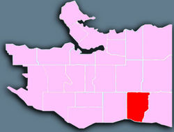
Victoria-Fraserview
Encyclopedia
Vancouver
Vancouver is a coastal seaport city on the mainland of British Columbia, Canada. It is the hub of Greater Vancouver, which, with over 2.3 million residents, is the third most populous metropolitan area in the country,...
, set on the south slope of the rise that runs north from the Fraser River
Fraser River
The Fraser River is the longest river within British Columbia, Canada, rising at Fraser Pass near Mount Robson in the Rocky Mountains and flowing for , into the Strait of Georgia at the city of Vancouver. It is the tenth longest river in Canada...
and encompassing a large area of residential and commercial development. Surrounding the culturally eclectic Victoria Drive corridor, Victoria-Fraserview is an ethnically diverse area that was one of the earliest areas of settlement in the region.
Geography
Stretching north from the Fraser River to East 41st Avenue, Victoria-Fraserview is bordered on the west by Knight Street - one of Vancouver's busiest north-south corridors - and on the east by a line including Elliott Street and Vivian Drive. It lies on a south-facing slope that looks over the Fraser River and Mitchell IslandMitchell Island
Mitchell Island is an island in the North Arm of the Fraser River in British Columbia, Canada, located between the cities of Vancouver and Richmond and is incorporated as part of the latter city...
towards Richmond
Richmond, British Columbia
Richmond is a coastal city, incorporated in the Canadian province of British Columbia. Part of Metro Vancouver, its neighbouring communities are Vancouver and Burnaby to the north, New Westminster to the east, and Delta to the south, while the Strait of Georgia forms its western border...
and Delta
Delta, British Columbia
Delta is a district municipality in British Columbia, and forms part of Metro Vancouver. Located south of Richmond, it is bordered by the Fraser River to the north, the United States to the south and the city of Surrey to the east...
. Much of the commercial development in the neighbourhood is focused along Victoria Drive, which features a range of ethnic shops and services. The neighbourhood is dominated by single-family residential residences, though some townhomes can be found throughout the area. Along the Fraser River, a portion of the development known as the Fraserlands has brought condominiums and other residential construction to former industrial lands.
History
Musqueam First NationsFirst Nations
First Nations is a term that collectively refers to various Aboriginal peoples in Canada who are neither Inuit nor Métis. There are currently over 630 recognised First Nations governments or bands spread across Canada, roughly half of which are in the provinces of Ontario and British Columbia. The...
tradition indicates that the flats along the Fraser River in the southeastern portion of Victoria-Fraserview was the site of an important village and a number of east-west trails leading to settlements in what is now New Westminster. The first European settlers arrived in the 1860s, and a wagon road constructed in 1875 to the west of Knight Street on what is now Fraser Street opened the vast acres of virgin forest to homesteaders. As part of the Municipality of South Vancouver, Victoria-Fraserview began to receive more attention from farmers who cleared land in the region. It became part of the city of Vancouver in 1929.
Much of the existing development in the neighbourhood came in the 1940s, when land was needed for returning veterans of World War II
World War II
World War II, or the Second World War , was a global conflict lasting from 1939 to 1945, involving most of the world's nations—including all of the great powers—eventually forming two opposing military alliances: the Allies and the Axis...
. 1,100 new homes were built in the area (and its neighbour to the west, Sunset) for these veterans, on land expropriated by the Canadian Mortgage and Housing Corporation despite protestations of neighbours.
In the early days of settlement, the floodplain
Floodplain
A floodplain, or flood plain, is a flat or nearly flat land adjacent a stream or river that stretches from the banks of its channel to the base of the enclosing valley walls and experiences flooding during periods of high discharge...
along the Fraser River was popular with small vegetable farmers, but later was taken over by industrial development along the working river. Since the 1980s, industrial land has slowly transformed to residential properties.
Features
British Columbia
British Columbia is the westernmost of Canada's provinces and is known for its natural beauty, as reflected in its Latin motto, Splendor sine occasu . Its name was chosen by Queen Victoria in 1858...
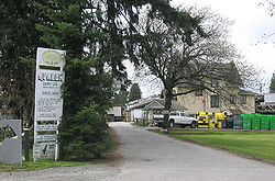
, operates out of the farmhouse built in 1908, and is still operated by the Crowley family.
Victoria-Fraserview contains eight parks and a number of walking trails along the Fraser River.