
Venezuelan Coastal Range
Encyclopedia
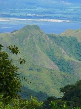
The Venezuelan Coastal Range (Spanish
Cordillera de la Costa; also known as Serranía de la Costa) is a mountain range
that runs along the central and eastern portions of Venezuela
's northern coast. The range is a northeastern extension of the Andes Mountains, and is also known as the Maritime Andes.

. The Cojedes River
separates the western end of Coastal Range from the Cordillera de Mérida
to the southeast. The range is divided into eastern and western sections by the wide bay between Cape Codera and Cumaná
.
In eastern section of the range, the parallel ranges are known as the Serranía del Litoral, which runs along the Caribbean coast, and the Serranía del Interior. The valley between these two ranges, which includes Lake Valencia
, the valleys of Caracas
, and the Tuy River at its eastern end, is the most densely peopled part of Venezuela. Caracas lies in a valley between two branches of the Serranía del Litoral: the Cerro El Ávila
to the north, and smaller hills to the south.
Both the littoral and interior ranges reappear between Cumaná and the Gulf of Paria
to form the eastern section of the cordillera. The Littoral range forms the Araya Peninsula
to the west and the Paria Peninsula
to the west, and extends across the straits known as the Dragon's Mouths to form the Northern Range
of the island of Trinidad
.
of the Deserts and xeric shrublands
Biome
. The Araya and Paria xeric scrub occupies the arid zones of Araya and Paria peninsulas, with the exception of the montane areas of the Paria Peninsula, which are included in the La Costa xeric shrublands ecoregion. The Araya and Paria xeric scrub also includes Isla Margarita
and extends south on to the mainland to Cumaná.
At elevations from 600 – 2675 meters lie the humid evergreen Cordillera de la Costa montane forests
ecoregion of the montane Tropical and subtropical moist broadleaf forests
Biome, which form eleven discontinuous enclaves across the high summits of the eastern and western portions of the range.
Spanish language
Spanish , also known as Castilian , is a Romance language in the Ibero-Romance group that evolved from several languages and dialects in central-northern Iberia around the 9th century and gradually spread with the expansion of the Kingdom of Castile into central and southern Iberia during the...
Cordillera de la Costa; also known as Serranía de la Costa) is a mountain range
Mountain range
A mountain range is a single, large mass consisting of a succession of mountains or narrowly spaced mountain ridges, with or without peaks, closely related in position, direction, formation, and age; a component part of a mountain system or of a mountain chain...
that runs along the central and eastern portions of Venezuela
Venezuela
Venezuela , officially called the Bolivarian Republic of Venezuela , is a tropical country on the northern coast of South America. It borders Colombia to the west, Guyana to the east, and Brazil to the south...
's northern coast. The range is a northeastern extension of the Andes Mountains, and is also known as the Maritime Andes.
Geography
The Coastal Range actually consists of two parallel ranges, which run east and west along the coast of the Caribbean SeaCaribbean Sea
The Caribbean Sea is a sea of the Atlantic Ocean located in the tropics of the Western hemisphere. It is bounded by Mexico and Central America to the west and southwest, to the north by the Greater Antilles, and to the east by the Lesser Antilles....
. The Cojedes River
Cojedes River
The Cojedes River is a tributary of the Orinoco River in central Venezuela. The Cojedes originates in Lara state, and flows southeast through a gap between the Cordillera de Mérida and the Cordillera de la Costa and across the Llanos grasslands of the Orinoco Basin to empty into the Apure River,...
separates the western end of Coastal Range from the Cordillera de Mérida
Cordillera de Mérida
The Cordillera de Mérida is a series of mountain ranges, or massif, in northwestern Venezuela. The Cordillera de Mérida is a northeastern extension of the Andes Mountains. The ranges run southwest–northeast between the Venezuelan–Colombian border and the Venezuelan coastal range...
to the southeast. The range is divided into eastern and western sections by the wide bay between Cape Codera and Cumaná
Cumaná
Cumaná is the capital of Venezuela's Sucre State. It is located 402 km east of Caracas. It was the first settlement founded by Europeans in the mainland America, in 1501 by Franciscan friars, but due to successful attacks by the indigenous people, it had to be refounded several times...
.
In eastern section of the range, the parallel ranges are known as the Serranía del Litoral, which runs along the Caribbean coast, and the Serranía del Interior. The valley between these two ranges, which includes Lake Valencia
Lake Valencia
Lake Valencia is the third largest lake in Venezuela, exceeded in size only by Lake Maracaibo and Lake Guri. It occupies one of the so-called Aragua valleys, enclosed between the parallel mountain ranges of the Cordillera de la Costa, the Maritime Andes. One part is within the limits of Carabobo...
, the valleys of Caracas
Caracas
Caracas , officially Santiago de León de Caracas, is the capital and largest city of Venezuela; natives or residents are known as Caraquenians in English . It is located in the northern part of the country, following the contours of the narrow Caracas Valley on the Venezuelan coastal mountain range...
, and the Tuy River at its eastern end, is the most densely peopled part of Venezuela. Caracas lies in a valley between two branches of the Serranía del Litoral: the Cerro El Ávila
Cerro El Ávila
The El Ávila National Park covers part of the mountainous region of the coastal area of north-central Venezuela. The area's highest elevation is Pico Naiguatá, at 2.765 meters above sea level...
to the north, and smaller hills to the south.
Both the littoral and interior ranges reappear between Cumaná and the Gulf of Paria
Gulf of Paria
The Gulf of Paria is a shallow inland sea between the island of Trinidad and the east coast of Venezuela. This sheltered body of water is considered to be one of the best natural harbours on the Atlantic coast of the Americas...
to form the eastern section of the cordillera. The Littoral range forms the Araya Peninsula
Araya Peninsula
The Araya Peninsula is a peninsula located in Venezuela just eastward out from its Caribbean coast, in the state of Sucre. The town of Araya is located on its westernmost extremity. It is the setting of the award-winning documentary film Araya ....
to the west and the Paria Peninsula
Paria Peninsula
Paria Peninsula is a large peninsula in Sucre State, northern Venezuela. It separates the Gulf of Paria and Caribbean Sea. Península de Paria National Park is located on the peninsula...
to the west, and extends across the straits known as the Dragon's Mouths to form the Northern Range
Northern Range
The Northern Range is the range of tall hills across the northern portion of Trinidad, the major island in the Republic of Trinidad and Tobago. The hills rise abruptly from the lowlands of northern Trinidad , but only the two tallest peaks, El Cerro del Aripo and El Tucuche top 900 m...
of the island of Trinidad
Trinidad
Trinidad is the larger and more populous of the two major islands and numerous landforms which make up the island nation of Trinidad and Tobago. It is the southernmost island in the Caribbean and lies just off the northeastern coast of Venezuela. With an area of it is also the fifth largest in...
.
Ecoregions
The lower elevations of the mountains are mostly covered by the La Costa xeric shrublands ecoregionEcoregion
An ecoregion , sometimes called a bioregion, is an ecologically and geographically defined area that is smaller than an ecozone and larger than an ecosystem. Ecoregions cover relatively large areas of land or water, and contain characteristic, geographically distinct assemblages of natural...
of the Deserts and xeric shrublands
Deserts and xeric shrublands
Deserts and xeric shrublands is a biome characterized by, relating to, or requiring only a small amount of moisture.-Definition and occurrence:...
Biome
Biome
Biomes are climatically and geographically defined as similar climatic conditions on the Earth, such as communities of plants, animals, and soil organisms, and are often referred to as ecosystems. Some parts of the earth have more or less the same kind of abiotic and biotic factors spread over a...
. The Araya and Paria xeric scrub occupies the arid zones of Araya and Paria peninsulas, with the exception of the montane areas of the Paria Peninsula, which are included in the La Costa xeric shrublands ecoregion. The Araya and Paria xeric scrub also includes Isla Margarita
Isla Margarita
Margarita Island is the largest island of the state of Nueva Esparta in Venezuela, situated in the Caribbean Sea, off the northeastern coast of the country. The state also contains two other smaller islands: Coche and Cubagua. The capital city of Nueva Esparta is La Asunción, located in a river...
and extends south on to the mainland to Cumaná.
At elevations from 600 – 2675 meters lie the humid evergreen Cordillera de la Costa montane forests
Cordillera de la Costa montane forests
The Cordillera de la Costa montane forests is a montane ecoregion of the Tropical and subtropical moist broadleaf forest Biome, in the Venezuelan Coastal Range on the Caribbean Sea in northern Venezuela.-Geography:...
ecoregion of the montane Tropical and subtropical moist broadleaf forests
Tropical and subtropical moist broadleaf forests
Tropical and subtropical moist broadleaf forests , also known as tropical moist forests, are a tropical and subtropical forest biome....
Biome, which form eleven discontinuous enclaves across the high summits of the eastern and western portions of the range.