

Vehicle registration plates of Nebraska
Encyclopedia
The U.S. state
of Nebraska
first required its residents to register their motor vehicle
s and display license plates in 1915. All plates were made of steel
until 1947 when aluminum plates were introduced.
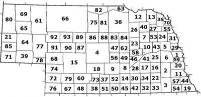 Nebraska established a county-coding system for its passenger plates in 1922. These one- or two-digit prefixes were assigned based on the number of registered vehicles per county in that year. In 2002, the Nebraska Legislature
discontinued the 1922 system for Douglas
, Lancaster
, and Sarpy
Counties.
U.S. state
A U.S. state is any one of the 50 federated states of the United States of America that share sovereignty with the federal government. Because of this shared sovereignty, an American is a citizen both of the federal entity and of his or her state of domicile. Four states use the official title of...
of Nebraska
Nebraska
Nebraska is a state on the Great Plains of the Midwestern United States. The state's capital is Lincoln and its largest city is Omaha, on the Missouri River....
first required its residents to register their motor vehicle
Motor vehicle
A motor vehicle or road vehicle is a self-propelled wheeled vehicle that does not operate on rails, such as trains or trolleys. The vehicle propulsion is provided by an engine or motor, usually by an internal combustion engine, or an electric motor, or some combination of the two, such as hybrid...
s and display license plates in 1915. All plates were made of steel
Steel
Steel is an alloy that consists mostly of iron and has a carbon content between 0.2% and 2.1% by weight, depending on the grade. Carbon is the most common alloying material for iron, but various other alloying elements are used, such as manganese, chromium, vanadium, and tungsten...
until 1947 when aluminum plates were introduced.
Passenger plates 1933 to present
| Image | Dates issued | Design | Slogan | Serial format | Serials issued | Notes |
|---|---|---|---|---|---|---|
| 1933 | Blue lettering and border embossed on yellow base. | none | Coded by county of issuance (probably). | 12-3456 | Issued in pairs, for front and rear of vehicle. | |
| 1996 | none | Coded by county of issuance:
|
||||
| 2002 | black on yellow | www.state.ne.us | ABC 123 | NAA 001 to ? | Issued in Douglas Douglas County, Nebraska -Demographics:As of the census of 2000, there were 463,585 people, 182,194 households, and 115,146 families residing in the county. The population density was 1,401 people per square mile . There were 192,672 housing units at an average density of 582 per square mile... , Lancaster Lancaster County, Nebraska -Demographics:As of the census of 2000, there were 250,291 people, 99,187 households, and 60,702 families residing in the county. The population density was 298 people per square mile . There were 104,217 housing units at an average density of 124 per square mile... , and Sarpy Sarpy County, Nebraska -Demographics:As of the census of 2000, there were 122,595 people, 43,426 households, and 33,220 families residing in the county. The population density was 510 people per square mile . There were 44,981 housing units at an average density of 187 per square mile... Counties. Initially issued stickers displaying county name. |
|
| Coded by county of issuance:
|
Issued in all other counties. | |||||
| 2005 | dark blue on gradient blue with Conestoga wagon Conestoga wagon The Conestoga wagon is a heavy, broad-wheeled covered wagon that was used extensively during the late 18th century and the 19th century in the United States and sometimes in Canada as well. It was large enough to transport loads up to 8 tons , and was drawn by horses, mules or oxen... |
state.ne.us | ABC 123 | Issued in Douglas, Lancaster, and Sarpy Counties. | ||
| Coded by county of issuance:
|
Issued in all other counties. |
County coding
Nebraska Legislature
The Nebraska Legislature is the supreme legislative body of the State of Nebraska, in the Great Plains region of the United States. The Legislature meets at the Nebraska State Capitol in the City of Lincoln, Lancaster County....
discontinued the 1922 system for Douglas
Douglas County, Nebraska
-Demographics:As of the census of 2000, there were 463,585 people, 182,194 households, and 115,146 families residing in the county. The population density was 1,401 people per square mile . There were 192,672 housing units at an average density of 582 per square mile...
, Lancaster
Lancaster County, Nebraska
-Demographics:As of the census of 2000, there were 250,291 people, 99,187 households, and 60,702 families residing in the county. The population density was 298 people per square mile . There were 104,217 housing units at an average density of 124 per square mile...
, and Sarpy
Sarpy County, Nebraska
-Demographics:As of the census of 2000, there were 122,595 people, 43,426 households, and 33,220 families residing in the county. The population density was 510 people per square mile . There were 44,981 housing units at an average density of 187 per square mile...
Counties.
| License plate prefix | County |
| 14 | Adams County Adams County, Nebraska Adams County is a county located in the U.S. state of Nebraska. As of July 1, 2006, the population estimate was 33,185. Its name is in honor of the second President of the United States, John Adams... |
| 26 | Antelope County Antelope County, Nebraska Antelope County is a county located in the U.S. state of Nebraska, and was formed in 1871. As of 2010, the population estimate was 6,685. Its county seat is Neligh... |
| 91 | Arthur County Arthur County, Nebraska -Demographics:As of the census of 2000, there were 444 people, 185 households, and 138 families residing in the county. The population density was 0.618 people per square mile . There were 273 housing units at an average density of 0.380 per square mile... |
| 85 | Banner County Banner County, Nebraska Banner County is a county located in the U.S. state of Nebraska. The population was 690 at the 2010 census. Its county seat is Harrisburg.Banner County is part of the Scottsbluff, Nebraska Micropolitan Statistical Area.... |
| 86 | Blaine County Blaine County, Nebraska -History:Blaine County was formed in 1885. It was named after presidential candidate James G. Blaine.-Demographics:As of the census of 2000, there were 583 people, 238 households, and 168 families residing in the county. The population density was 1 people per square mile . There were 333 housing... |
| 23 | Boone County Boone County, Nebraska -Demographics:As of the census of 2000, there were 6,259 people, 2,454 households, and 1,700 families residing in the county. The population density was 9 people per square mile . There were 2,733 housing units at an average density of 4 per square mile... |
| 65 | Box Butte County Box Butte County, Nebraska -Demographics:As of the census of 2000, there were 12,158 people, 4,780 households, and 3,298 families residing in the county. The population density was 11 people per square mile . There were 5,488 housing units at an average density of 5 per square mile... |
| 63 | Boyd County Boyd County, Nebraska Boyd County is a county located in the U.S. state of Nebraska. As of 2010, the population is 2,099. Its county seat is Butte.In the Nebraska license plate system, Boyd County is represented by the prefix 63 .-Geography:According to the U.S... |
| 75 | Brown County Brown County, Nebraska -Demographics:As of the census of 2000, there were 3,525 people, 1,530 households, and 996 families residing in the county. The population density was 3 people per square mile . There were 1,916 housing units at an average density of 2 per square mile... |
| 9 | Buffalo County Buffalo County, Nebraska -Demographics:As of the census of 2000, there were 42,259 people, 15,930 households, and 10,227 families residing in the county. The population density was 44 people per square mile . There were 16,830 housing units at an average density of 17 per square mile... |
| 31 | Burt County Burt County, Nebraska -History:Burt County was formed in 1854. It was named after Francis Burt, the first governor of Nebraska Territory.-Demographics:As of the census of 2000, there were 7,791 people, 3,155 households, and 2,240 families residing in the county. The population density was 16 people per square mile . ... |
| 25 | Butler County Butler County, Nebraska -Demographics:As of the census of 2000, there were 8,767 people, 3,426 households, and 2,350 families residing in the county. The population density was 15 people per square mile . There were 3,901 housing units at an average density of 7 per square mile... |
| 20 | Cass County Cass County, Nebraska -Other Geographical notes:Due to its proximity to Cass County, Iowa, and because both of those counties receive most of their broadcasts from Omaha, Nebraska, references to 'Cass County' must be frequently disambiguated, or result in confusion.-Demographics:... |
| 13 | Cedar County Cedar County, Nebraska -History:Cedar County was formed in 1855. It was named for the great number of cedars that grow there.-Demographics:As of the census of 2000, there were 9,615 people, 3,623 households, and 2,565 families residing in the county. The population density was 13 people per square mile . There were... |
| 72 | Chase County Chase County, Nebraska -Demographics:As of the census of 2000, there were 4,068 people, 1,662 households, and 1,163 families residing in the county. The population density was 4 people per square mile . There were 1,927 housing units at an average density of 2 per square mile... |
| 66 | Cherry County Cherry County, Nebraska Cherry County is unusual in being split between two time zones, Mountain Time and Central Time. The lines between the two runs roughly north to south along the eastern third of the county. Cherry County is also the location of the Valentine National Wildlife Refuge, the Fort Niobrara National... |
| 39 | Cheyenne County Cheyenne County, Nebraska -History:Cheyenne County was formed in 1871. It was named after the Cheyenne Native American tribe.-Demographics:As of the census of 2000, of 2000, there were 9,830 people, 4,071 households, and 2,686 families residing in the county. The population density was 8 people per square mile . There... |
| 30 | Clay County Clay County, Nebraska -Demographics:As of the census of 2000, there were 7,039 people, 2,756 households, and 1,981 families residing in the county. The population density was 12 people per square mile . There were 3,066 housing units at an average density of 5 per square mile... |
| 43 | Colfax County Colfax County, Nebraska -Demographics:As of the census of 2000, there were 10,441 people, 3,682 households, and 2,592 families residing in the county. The population density was 25 people per square mile . There were 4,088 housing units at an average density of 10 per square mile... |
| 24 | Cuming County Cuming County, Nebraska -History:Cuming County was formed in 1855. It was named after Thomas B. Cuming, an early governor of this territory.-Demographics:As of the census of 2000, there were 10,203 people, 3,945 households, and 2,757 families residing in the county. The population density was 18 people per square mile... |
| 4 | Custer County Custer County, Nebraska -History:Custer County was formed in 1877. It was named after General George Armstrong Custer, who was killed at the Battle of Little Bighorn.-Demographics:... |
| 70 | Dakota County Dakota County, Nebraska -Demographics:As of the census of 2000, there were 20,253 people, 7,095 households, and 5,087 families residing in the county. The population density was 77 people per square mile . There were 7,528 housing units at an average density of 28 per square mile... |
| 69 | Dawes County Dawes County, Nebraska -National protected areas:*Nebraska National Forest *Oglala National Grassland *Pine Ridge National Recreation Area-Demographics:As of the census of 2000, there were 9,060 people, 3,512 households, and 2,086 families residing in the county. The population density was 6 people per square mile... |
| 18 | Dawson County Dawson County, Nebraska Dawson County is a county located in the U.S. state of Nebraska. As of 2010, the population was 24,326. Its county seat is Lexington.Dawson County is part of the Lexington, Nebraska, Micropolitan Statistical Area.... |
| 78 | Deuel County Deuel County, Nebraska -History:Deuel County was formed in 1889. It was named after Harry Porter Deuel, an early pioneer in this area.-Demographics:As of the census of 2000, there were 2,098 people, 908 households, and 601 families residing in the county. The population density was 5 people per square mile . There were... |
| 35 | Dixon County Dixon County, Nebraska -Demographics:As of the census of 2000, there were 6,339 people, 2,413 households, and 1,705 families residing in the county. The population density was 13 people per square mile . There were 2,673 housing units at an average density of 6 per square mile... |
| 5 | Dodge County Dodge County, Nebraska - History :Dodge County was formed in 1855. It was named after the US Senator Augustus Caesar Dodge.- Demographics :As of the census of 2000, there were 36,160 people, 14,433 households, and 9,756 families residing in the county. The population density was 68 people per square mile . There were... |
| 1 | Douglas County Douglas County, Nebraska -Demographics:As of the census of 2000, there were 463,585 people, 182,194 households, and 115,146 families residing in the county. The population density was 1,401 people per square mile . There were 192,672 housing units at an average density of 582 per square mile... |
| 76 | Dundy County Dundy County, Nebraska -Demographics:As of the census of 2000, there were 2,292 people, 961 households, and 637 families residing in the county. The population density was 2 people per square mile . There were 1,196 housing units at an average density of 1 per square mile... |
| 34 | Fillmore County Fillmore County, Nebraska -Hunting:Fillmore is popular with hunters of pheasant, deer, Canada goose and other popular game animals.-Organizations:Fillmore County is home to a nonprofit organization which promotes education and the development of habitat for butterflies in Nebraska.... |
| 50 | Franklin County Franklin County, Nebraska -Demographics:As of the census of 2000, there were 3,574 people, 1,485 households, and 1,021 families residing in the county. The population density was 6 people per square mile . There were 1,746 housing units at an average density of 3 per square mile... |
| 60 | Frontier County Frontier County, Nebraska -History:Frontier County was formed in 1872. It was named for its location along the frontier border in the late 19th century.-Demographics:As of the census of 2000, there were 3,099 people, 1,192 households, and 828 families residing in the county. The population density was 3 people per square... |
| 38 | Furnas County Furnas County, Nebraska -Demographics:As of the census of 2000, there were 5,324 people, 2,278 households, and 1,489 families residing in the county. The population density was 7 people per square mile . There were 2,730 housing units at an average density of 4 per square mile... |
| 3 | Gage County Gage County, Nebraska -History:Gage County was formed with land taken from the Oto in an 1854 treaty. It was named after the minister William D. Gage.-Demographics:As of the census of 2000, there were 22,993 people, 9,316 households, and 6,204 families residing in the county. The population density was 27 people per... |
| 77 | Garden County Garden County, Nebraska -History:Garden County was formed in 1909 by popular vote. Voters in the general election of November 2, 1909, approved making the northern part of Deuel County into its own county... |
| 83 | Garfield County Garfield County, Nebraska -Demographics:As of the census of 2000, there were 1,902 people, 813 households, and 529 families residing in the county. The population density was 3 people per square mile . There were 1,021 housing units at an average density of 2 per square mile... |
| 73 | Gosper County Gosper County, Nebraska -History:Gosper County was formed in 1873. It was named after John J. Gosper, a Secretary of State of Nebraska.-Demographics:As of the census of 2000, there were 2,143 people, 863 households, and 655 families residing in the county. The population density was 5 people per square mile . There were... |
| 92 | Grant County Grant County, Nebraska -Demographics:As of the census of 2000, there were 747 people, 292 households, and 226 families residing in the county. The population density was 0.95 people per square mile . There were 449 housing units at an average density of 0.57 per square mile . The racial makeup of the county was... |
| 62 | Greeley County Greeley County, Nebraska -History:Greeley County was formed in 1871. It was named after Horace Greeley, a newspaper editor and politician of the mid-19th century.-Demographics:... |
| 8 | Hall County Hall County, Nebraska -History:Hall County was formed in 1858. It was named after Augustus Hall, an early judge of this territory.- Demographics :As of the census of 2000, there were 53,534 people, 20,356 households, and 14,086 families residing in the county. The population density was 98 people per square mile... |
| 28 | Hamilton County Hamilton County, Nebraska -Demographics:As of the census of 2000, there were 9,403 people, 3,503 households, and 2,676 families residing in the county. The population density was 17 people per square mile . There were 3,850 housing units at an average density of 7 per square mile... |
| 51 | Harlan County Harlan County, Nebraska -History:Prior to 1870, the portion of the Republican valley that now includes Harlan County was a prized hunting ground for the Native Americans; and the threat of attack deterred white settlement in the area... |
| 79 | Hayes County Hayes County, Nebraska -History:Hayes County was formed in 1877. It was named after President Rutherford B. Hayes.-Demographics:As of the census of 2000, there were 1,068 people, 430 households, and 312 families residing in the county. The population density was 2 people per square mile . There were 526 housing units... |
| 67 | Hitchcock County Hitchcock County, Nebraska -History:Hitchcock County was formed in 1873. It was named after the US Senator Phineas Warren Hitchcock.-Demographics:As of the census of 2000, there were 3,111 people, 1,287 households, and 899 families residing in the county. The population density was 4 people per square mile . There were... |
| 36 | Holt County Holt County, Nebraska -History:The county was created by an act of the Nebraska Legislature in 1862. It is named for Joseph Holt of Kentucky, who was Postmaster General and Secretary of War under President James Buchanan... |
| 93 | Hooker County Hooker County, Nebraska -History:Hooker County was formed in 1889. It was named after General Joseph Hooker.-Demographics:As of the census of 2000, there were 783 people, 335 households, and 220 families residing in the county. The population density was 1 person per square mile . There were 440 housing units at an... |
| 49 | Howard County Howard County, Nebraska -History:Howard County was formed in 1871. It was named after the Union General Oliver Otis Howard.-Demographics:As of the census of 2000, there were 6,567 people, 2,546 households, and 1,797 families residing in the county. The population density was 12 people per square mile . There were 2,782... |
| 33 | Jefferson County Jefferson County, Nebraska -Demographics:As of the census of 2000, there were 8,333 people, 3,527 households, and 2,352 families residing in the county. The population density was 14 people per square mile . There were 3,942 housing units at an average density of 7 per square mile... |
| 57 | Johnson County Johnson County, Nebraska -History:Johnson County was formed in 1855. It was named after Vice President Richard M. Johnson.-Demographics:As of the census of 2000, there were 4,488 people, 1,887 households, and 1,254 families residing in the county. The population density was 12 people per square mile . There were 2,116... |
| 52 | Kearney County Kearney County, Nebraska -History:Kearney County was formed in 1860. It was named after Fort Kearny, which in turn was named after Brigade General Stephen W. Kearny.-Demographics:... |
| 68 | Keith County Keith County, Nebraska -History:Keith County was formed in 1873. It was named after Morrill C. Keith, the grandfather of Governor Keith Neville.-Demographics:As of the census of 2000, there were 8,875 people, 3,707 households, and 2,535 families residing in the county. The population density was 8 people per square mile... |
| 82 | Keya Paha County Keya Paha County, Nebraska -Demographics:As of the census of 2000, there were 983 people, 409 households, and 292 families residing in the county. The population density was 1 people per square mile . There were 548 housing units at an average density of 1 per square mile . The racial makeup of the county was 99.39%... |
| 71 | Kimball County Kimball County, Nebraska -History:Kimball County was formed in 1888. It was named after railroad pioneer Thomas L. Kimball.-Demographics:As of the census of 2000, there were 4,089 people, 1,727 households, and 1,136 families residing in the county. The population density was 4 people per square mile . There were 1,972... |
| 12 | Knox County Knox County, Nebraska -History:The Lewis and Clark Expedition passed through the area on 4 September 1804.The US Treaty with the Ponca tribe was signed at White Paint Creek on 9 June 1825.Knox County was formed in 1854. It was named after Major General Henry Knox.-Demographics:... |
| 2 | Lancaster County Lancaster County, Nebraska -Demographics:As of the census of 2000, there were 250,291 people, 99,187 households, and 60,702 families residing in the county. The population density was 298 people per square mile . There were 104,217 housing units at an average density of 124 per square mile... |
| 15 | Lincoln County Lincoln County, Nebraska -Demographics:As of the census of 2000, there were 34,632 people, 14,076 households, and 9,444 families residing in the county. The population density was 14 people per square mile . There are 15,438 housing units in Lincoln.... |
| 87 | Logan County Logan County, Nebraska -History:Logan County was formed in 1885. It was named after the Union General John A. Logan.-Demographics:As of the census of 2000, there were 774 people, 316 households, and 229 families residing in the county. The population density was 1 people per square mile . There were 386 housing units... |
| 88 | Loup County Loup County, Nebraska -Demographics:As of the census of 2010, there were 632 people, 289 households, and 206 families residing in the county. The population density was 1 people per square mile . There were 377 housing units at an average density of 1 per square mile... |
| 90 | McPherson County McPherson County, Nebraska -History:McPherson County was formed in 1887. It was named after Union General James B. McPherson.-Demographics:As of the census of 2000, there were 533 people, 202 households, and 157 families residing in the county. The population density was 1 people per square mile . There were 283 housing... |
| 7 | Madison County Madison County, Nebraska -Demographics:As of the census of 2000, there were 35,226 people, 13,436 households, and 8,894 families residing in the county. The population density was 62 people per square mile . There were 14,432 housing units at an average density of 25 per square mile... |
| 46 | Merrick County Merrick County, Nebraska -Demographics:As of the census of 2000, there were 8,204 people, 3,209 households, and 2,307 families residing in the county. The population density was 17 people per square mile . There were 3,649 housing units at an average density of 8 per square mile... |
| 64 | Morrill County Morrill County, Nebraska -History:Morrill County was formed in 1908 "carved out of Cheyenne County". It was named after Charles Henry Morrill, a president of the Lincoln Land Company.-Demographics:... |
| 58 | Nance County Nance County, Nebraska -History:The land that comprises Nance County was originally part of the Pawnee Reservation, created in 1857 when the Pawnee Indians signed a treaty with the United States ceding its lands in exchange for the reservation. After the state of Nebraska was admitted into the Union, the state government... |
| 44 | Nemaha County Nemaha County, Nebraska -Demographics:As of the census of 2000, there were 7,576 people, 3,047 households, and 1,980 families residing in the county. The population density was 18 people per square mile . There were 3,439 housing units at an average density of 8 per square mile... |
| 42 | Nuckolls County Nuckolls County, Nebraska Nuckolls County is a county located in the U.S. state of Nebraska. As of the 2010 census, the county population was 4,500. Its county seat is Nelson.... |
| 11 | Otoe County Otoe County, Nebraska -History:Otoe County was formed in 1854. It was named after the Otoe Indian tribe.-Demographics:As of the census of 2000, there were 15,396 people, 6,060 households, and 4,229 families residing in the county. The population density was 25 people per square mile . There were 6,567 housing units... |
| 54 | Pawnee County Pawnee County, Nebraska -Demographics:As of the census of 2000, there were 3,087 people, 1,339 households, and 850 families residing in the county. The population density was 7 people per square mile . There were 1,587 housing units at an average density of 4 per square mile... |
| 74 | Perkins County Perkins County, Nebraska -History:Perkins County was formed in 1887. It was named after Charles E. Perkins, the president of a railroad.-Demographics:As of the census of 2000, there were 3,200 people, 1,275 households, and 893 families residing in the county. The population density was 4 people per square mile . There... |
| 37 | Phelps County Phelps County, Nebraska -History:Phelps County was formed in 1873. It was named after William Phelps, an early settler in this area.-Demographics:As of the census of 2000, there were 9,747 people, 3,844 households, and 2,683 families residing in the county. The population density was 18 people per square mile . There... |
| 40 | Pierce County Pierce County, Nebraska -History:Pierce County was formed in 1856. It was named after President Franklin Pierce.-Demographics:As of the census of 2000, there were 7,857 people, 2,979 households, and 2,141 families residing in the county. The population density was 14 people per square mile . There were 3,247 housing... |
| 10 | Platte County Platte County, Nebraska -Demographics:As of the census of 2000, there were 31,662 people, 12,076 households, and 8,465 families residing in the county. The population density was 47 people per square mile . There were 12,916 housing units at an average density of 19 per square mile... |
| 41 | Polk County Polk County, Nebraska -Demographics:As of the census of 2000, there were 5,639 people, 2,259 households, and 1,570 families residing in the county. The population density was 5/km² . There were 2,717 housing units at an average density of 2/km²... |
| 48 | Red Willow County Red Willow County, Nebraska -History:Red Willow County was formed in 1873. It was named after the Red Willow Creek.-Demographics:As of the census of 2000, there were 11,448 people, 4,710 households, and 3,188 families residing in the county. The population density was 16 people per square mile . There were 5,278 housing... |
| 19 | Richardson County Richardson County, Nebraska -Demographics:As of the census of 2000, there were 9,531 people, 3,993 households, and 2,567 families residing in the county. The population density was 17 people per square mile . There were 4,560 housing units at an average density of 8 per square mile... |
| 81 | Rock County Rock County, Nebraska -National protected areas:* John and Louise Seier National Wildlife Refuge* Niobrara National Scenic River -Demographics:As of the census of 2000, there were 1,756 people, 763 households, and 501 families residing in the county. The population density was 2 people per square mile . There were 935... |
| 22 | Saline County Saline County, Nebraska -Demographics:As of the census of 2000, there were 13,843 people, 5,188 households, and 3,507 families residing in the county. The population density was 24 people per square mile . There were 5,611 housing units at an average density of 10 per square mile... |
| 59 | Sarpy County Sarpy County, Nebraska -Demographics:As of the census of 2000, there were 122,595 people, 43,426 households, and 33,220 families residing in the county. The population density was 510 people per square mile . There were 44,981 housing units at an average density of 187 per square mile... |
| 6 | Saunders County Saunders County, Nebraska -History:Saunders County was established by an 1856 act of the Nebraska Territorial Legislature; its boundaries were redefined in 1858. The county was originally named after John C... |
| 21 | Scotts Bluff County Scotts Bluff County, Nebraska -National protected area:* North Platte National Wildlife Refuge* Scotts Bluff National Monument-Demographics:As of the census of 2000, there were 36,951 people, 14,887 households, and 10,167 families residing in the county. The population density was 50 people per square mile . There were 16,119... |
| 16 | Seward County Seward County, Nebraska -Demographics:As of the census of 2000, there were 16,496 people, 6,013 households, and 4,215 families residing in the county. The population density was 29 people per square mile . There were 6,428 housing units at an average density of 11 per square mile... |
| 61 | Sheridan County Sheridan County, Nebraska -History:Sheridan County was formed in 1885. It was named after General Philip H. Sheridan.-Demographics:As of the census of 2000, there were 6,198 people, 2,549 households, and 1,728 families residing in the county. The population density was 2 people per square mile . There were 3,013 housing... |
| 56 | Sherman County Sherman County, Nebraska -History:Sherman County was formed in 1871. It was named after General William Tecumseh Sherman.-Demographics:As of the census of 2000, there were 3,318 people, 1,394 households, and 935 families residing in the county. The population density was 6 people per square mile . There were 1,839... |
| 80 | Sioux County Sioux County, Nebraska -National protected areas:* Agate Fossil Beds National Monument* Nebraska National Forest * Oglala National Grassland -Demographics:... |
| 53 | Stanton County Stanton County, Nebraska -History:Stanton County was formed in 1865. It was named after the Secretary of War Edwin M. Stanton during the administration of President Abraham Lincoln.-Demographics:... |
| 32 | Thayer County Thayer County, Nebraska -History:Thayer County was formed in 1872. It was named after the General and Governor John Milton Thayer.-Demographics:As of the census of 2000, there were 6,055 people, 2,541 households, and 1,689 families residing in the county. The population density was 10 people per square mile . There were... |
| 89 | Thomas County Thomas County, Nebraska -History:Thomas County was formed in 1887. It was named after General George H. Thomas.-Demographics:As of the census of 2000, there were 729 people, 325 households, and 216 families residing in the county. The population density was 1 person per square mile . There were 446 housing units at an... |
| 55 | Thurston County Thurston County, Nebraska -History:Varying cultures of indigenous peoples lived along the rivers for thousands of years before European encounter.Thurston County was organized by European Americans in 1889 from land that had been divided between Dakota and Burt counties since the dissolution of Blackbird County in 1879. It... |
| 47 | Valley County Valley County, Nebraska -Demographics:As of the census of 2000, there were 4,647 people, 1,965 households, and 1,298 families residing in the county. The population density was 8 people per square mile . There were 2,273 housing units at an average density of 4 per square mile... |
| 29 | Washington County Washington County, Nebraska -National protected areas:*Boyer Chute National Wildlife Refuge*DeSoto National Wildlife Refuge -Demographics:As of the census of 2000, there were 18,780 people, 6,940 households, and 5,149 families residing in the county. The population density was 48 people per square mile . There were 7,408... |
| 27 | Wayne County Wayne County, Nebraska -Demographics:As of the census of 2000, there were 9,851 people, 3,437 households, and 2,206 families residing in the county. The population density was 22 people per square mile . There were 3,662 housing units at an average density of 8 per square mile... |
| 45 | Webster County Webster County, Nebraska -History:Webster County was formed in 1871. It was named after the statesman Daniel Webster.-Demographics:As of the census of 2000, there were 4,061 people, 1,708 households, and 1,118 families residing in the county. The population density was 7 people per square mile . There were 1,972 housing... |
| 84 | Wheeler County Wheeler County, Nebraska -History:Wheeler County was formed in 1877. It was named after Major Daniel H. Wheeler.-Demographics:As of the census of 2000, there were 886 people, 352 households, and 243 families residing in the county. The population density was 2 people per square mile . There were 561 housing units at an... |
| 17 | York County York County, Nebraska -History:York County was formed in 1855. It was either named after the city York in England or for York County in Pennsylvania.-Demographics:As of the census of 2000, there were 14,598 people, 5,722 households, and 3,931 families residing in the county. The population density was 25 people per... |