
Vega Baja, Puerto Rico
Encyclopedia
Vega Baja (ˈbeɣa ˈβaxa) is a municipality
Municipality
A municipality is essentially an urban administrative division having corporate status and usually powers of self-government. It can also be used to mean the governing body of a municipality. A municipality is a general-purpose administrative subdivision, as opposed to a special-purpose district...
in north central Puerto Rico
Puerto Rico
Puerto Rico , officially the Commonwealth of Puerto Rico , is an unincorporated territory of the United States, located in the northeastern Caribbean, east of the Dominican Republic and west of both the United States Virgin Islands and the British Virgin Islands.Puerto Rico comprises an...
located in the northern coast, north of Morovis
Morovis, Puerto Rico
Morovis is a municipality of Puerto Rico located in the central region of the island, north of Orocovis, south of Manatí, Vega Baja and Vega Alta; east of Ciales, and west of Corozal. Morovis is spread over 13 wards and Morovis Pueblo...
; east of Manatí
Manatí, Puerto Rico
Manatí is a municipality of Puerto Rico in the northern coast, north of Morovis and Ciales; east of Florida and Barceloneta; and west of Vega Baja. Manatí is spread over 8 wards and Manatí Pueblo...
; and west of Vega Alta
Vega Alta, Puerto Rico
Vega Alta is a municipality of Puerto Rico. Vega Alta is located on the northern coast of the island, north of Morovis and Corozal; east of Vega Baja; and west of Dorado with an area of . Vega Alta is spread over seven wards and Vega Alta Pueblo...
. Vega Baja is spread over 13 wards and Vega Baja Pueblo (The downtown area and the administrative center of the city). It is part of the San Juan-Caguas-Guaynabo Metropolitan Statistical Area.
History
Vega Baja was founded on October 3, 1776 by Antonio Viera, with the name of "Vega-baxa del Naranjal de Nuestra Señora del Rosario"."Cibuco", name of one of the rivers that carve its fertile lands, is a variation of the name "Sebuco", a chief or Cacique
Cacique
Cacique is a title derived from the Taíno word for the pre-Columbian chiefs or leaders of tribes in the Bahamas, Greater Antilles, and the northern Lesser Antilles...
Taíno Indian of the region. These "cells" of Taíno
Taíno people
The Taínos were pre-Columbian inhabitants of the Bahamas, Greater Antilles, and the northern Lesser Antilles. It is thought that the seafaring Taínos are relatives of the Arawak people of South America...
indians were known to settle in the vicinity of the rivers. Even though the Cibuco river
Río Cibuco
-See also:*List of rivers of Puerto Rico-References:*USGS Hydrologic Unit Map – Caribbean Region *...
is prone to floods due to heavy seasonal rains even to this day, the benefits given to the land by the river are numerous. The rich diversity of ocean life and reefs is evidence of how the nutrients provided by the Cibuco river are so beneficial.
Taino carvings have been found on the exposed reefs in the vicinity of the Cibuco river. Amongh these carvings, one depicting a face and others shaped as fish. They are an indication that these reefs were frequented for spear fishing and perhaps other day to day activities.
Flag
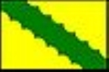
Vega Baja's flag consists of a yellow cloth, crossed by a green band. The band relates to the fertile valley and the river..Coat of Arms
The Vega Baja Coat of Arms has a v-shape green band, with overlapping roses in silver and three oranges tress, with fruits in gold. In the superior part a five tower crown, silverplated with black and green. The main colors of the shield; green and gold are used traditionally in civic, scholastic and sport activities. The crown five tower indicates that the town holds the rank of Villa by Royal Real Decree.Barrios (Districts/Wards)
- Algarrobo
- Almirante Norte
- Almirante Sur
- Cabo Caribe
- Ceiba
- Pueblo Nuevo
- Puerto Nuevo
- Pugnado Adentro
- Pugnado Afuera
- Quebrada Arenas
- Río Abajo
- Río Arriba
- Vega Baja Pueblo
- Yeguada
- Altos de Cuba
- Brisas de Tortuguero
- Jardines De Vega Baja
Industry
- Clothing, leather articles; electrical and electronic equipment, machinery
- Medical, and pharmaceutical.
Commercial Rug/Carpet Manufacture
The most prestigious commercial rug and carpet factory of the "New World" — V'Soske, located in "Pugnado Afuera".
Landmarks and places of interest
- Casa Alonso Museum
- El Trece Recreational Area
- Fenix Theater
- Hall Of Fame
- House of Culture and Tourism
- Jorge Otero Military Museum
- Man of the Sugar Cane Monument
- Melao Melao Artisan Center
- Migrante Square
- Puerto Nuevo Recreational Area
- Tortuguero LagoonTortuguero LagoonLaguna Tortuguero Natural Reserve is a natural reservoir located between the municipalities of Vega Baja and Manatí in Puerto Rico.The lagoon is one of only two natural reservoirs in the island of Puerto Rico , and is home to an ample variety of species.- General Information :Tortuguero Lagoon...
- Tortuguero Recreational Area
- Trinitarias Park
- Vega Serena
- Casa de Ramon Armaiz
Festivals and events
Melao Melao Marathon - OctoberMatron Celebrations - October
Christmas Festival - December
"Blue Marlin" Fishing Tournament
Elementary schools
- Agapito Rosario Rosario
- Almirante Sur II
- Almirantito
- Cabo Caribe
- Centro Comunal
- Dr. Jesús M. Armaiz
- Federico Degetau
- Fernando Rosario Vázquez
- José de Diego
- José Gualberto Padilla
- Manuel Negrón Collazo I
- Manuel Padilla Dávila
- Ofelia Díaz
- Rafael Hernández
- Rosa M. Rodríguez
- San Vicente
Middle schools/ Secondary/ Second Unit
- Ángel Sandín Martínez
- Brígida Álvarez Rodríguez
- Centro De Adiestramiento
- Segunda Unidad Pugnado Afuera (S.U.P.A) o Segunda Unidad Manuel A. Martínez Dávila
- Segunda Unidad Almirante Norte (S.U.A.N)