
Varenne River
Encyclopedia
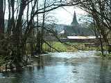
The Varenne is a river of Normandy
, France
, 40 kilometres (24.9 mi) in length, flowing through the department of Seine-Maritime
and it is a tributary of the Arques River
.
near to Montérolier
, Its valley separates the pays de Caux
on the west bank from the pays de Bray
to the east.
Of the three rivers that form the Arques, the Varenne is the shortest but paradoxically has the largest catchment area and highest speed (3.5 m/s). The only significant tributary is the Herring Creek (8 km in length) which joins on the left bank at Rosay
.
Its course takes it past the communes of Saint-Martin-Osmonville
, Saint-Saëns
, through the forest of Eawy and on to Bellencombre
, Saint-Hellier
, Torcy-le-Grand
, Torcy-le-Petit
, Martigny
, and finally Arques-la-Bataille
where it joins the Eaulne
and the Béthune River
s to form the Arques River
.
Like other rivers in the region, the Varenne is classified as a first class river, offering anglers the chance to catch salmon and trout. The river is also used near its source, to supply the drinking water system.
Normandy
Normandy is a geographical region corresponding to the former Duchy of Normandy. It is in France.The continental territory covers 30,627 km² and forms the preponderant part of Normandy and roughly 5% of the territory of France. It is divided for administrative purposes into two régions:...
, France
France
The French Republic , The French Republic , The French Republic , (commonly known as France , is a unitary semi-presidential republic in Western Europe with several overseas territories and islands located on other continents and in the Indian, Pacific, and Atlantic oceans. Metropolitan France...
, 40 kilometres (24.9 mi) in length, flowing through the department of Seine-Maritime
Seine-Maritime
Seine-Maritime is a French department in the Haute-Normandie region in northern France. It is situated on the northern coast of France, at the mouth of the Seine, and includes the cities of Rouen and Le Havre...
and it is a tributary of the Arques River
Arques River
The river Arques is a watercourse located in the Seine-Maritime département of the Haute-Normandie region of northern France. Only 6 kilometres in length, the river is formed by the confluence of three rivers at Arques-la-Bataille: The Eaulne, the Béthune and the Varenne which drain the pays de...
.
Geography
The river’s source is just northwest of BuchyBuchy, Seine-Maritime
Buchy is a commune in the Seine-Maritime department in the Haute-Normandie region in northern France.The inhabitants of the town of Buchy are "Buchois, Buchoises."-Geography:...
near to Montérolier
Montérolier
Montérolier is a commune in the Seine-Maritime department in the Haute-Normandie region in northern France.-Geography:A farming village situated in the Pays de Bray, some southeast of Dieppe at the junction of the D24 and the D38 roads...
, Its valley separates the pays de Caux
Pays de Caux
The Pays de Caux is an area in Normandy occupying the greater part of the French département of Seine Maritime in Haute-Normandie. It is a chalk plateau to the north of the Seine Estuary and extending to the cliffs on the English Channel coast - its coastline is known as the Côte d'Albâtre...
on the west bank from the pays de Bray
Pays de Bray
The Pays de Bray is a small natural region of France situated to the north-east of Rouen, straddling the French départements of the Seine-Maritime and Oise...
to the east.
Of the three rivers that form the Arques, the Varenne is the shortest but paradoxically has the largest catchment area and highest speed (3.5 m/s). The only significant tributary is the Herring Creek (8 km in length) which joins on the left bank at Rosay
Rosay, Seine-Maritime
Rosay is a commune in the Seine-Maritime department in the Haute-Normandie region in northern France.-Geography:A forestry and farming village situated by the banks of the Varenne River in the Pays de Bray at the junction of the D195, D97 and the D98 roads, some south of ...
.
Its course takes it past the communes of Saint-Martin-Osmonville
Saint-Martin-Osmonville
Saint-Martin-Osmonville is a commune in the Seine-Maritime department in the Haute-Normandie region in northern France.The inhabitants of the town of Saint-Martin-Osmonville are "St. Martin, St...
, Saint-Saëns
Saint-Saëns, Seine-Maritime
Saint-Saëns is a commune in the Seine-Maritime department in the Haute-Normandie region in northern France.-Geography:A small town of farming and associated light industry situated by the banks of the Varenne River in the Pays de Bray, some southeast of Dieppe at the junction of the D929, D12, D99...
, through the forest of Eawy and on to Bellencombre
Bellencombre
Bellencombre is a commune in the Seine-Maritime department in the Haute-Normandie region in northern France.-Geography:A forestry and farming village situated by the banks of the Varenne River in the Pays de Bray, some south of Dieppe at the junction of the D151, D154 and D48...
, Saint-Hellier
Saint-Hellier
Saint-Hellier is a commune in the Seine-Maritime department in the Haute-Normandie region in northern France.-Geography:A forestry and farming village situated by the banks of the Varenne River in the Pays de Caux, at the junction of the D15, the D76 and the D154 road, some south of...
, Torcy-le-Grand
Torcy-le-Grand, Seine-Maritime
Torcy-le-Grand is a commune in the Seine-Maritime department in the Haute-Normandie region in northern France.-Geography:A farming village situated in the Pays de Caux and by the banks of the Varenne River, some south of Dieppe at the junction of the D915, the D154 and the D149...
, Torcy-le-Petit
Torcy-le-Petit, Seine-Maritime
Torcy-le-Petit is a commune in the Seine-Maritime department in the Haute-Normandie region in northern France.-Geography:A farming village situated in the Pays de Caux and by the banks of the Varenne River, some south of Dieppe at the junction of the D915 and the D149...
, Martigny
Martigny, Seine-Maritime
Martigny is a commune in the Seine-Maritime department in the Haute-Normandie region in northern France.-Geography:A farming village situated by the banks of the Varenne River in the Pays de Caux, some southeast of Dieppe on the D154 road...
, and finally Arques-la-Bataille
Arques-la-Bataille
Arques-la-Bataille is a commune in the Seine-Maritime department in the Haute-Normandie region in northern France.-Geography:Arques is situated near the confluence of the rivers Eaulne, Varenne and Béthune, with the forest of Arques to the north-east...
where it joins the Eaulne
Eaulne
The river Eaulne is one of the rivers that flow from the plateau of the eastern Pays de Caux in the Seine-Maritime département of Haute-Normandie in northern France. The Eaulne’s source is at Mortemer...
and the Béthune River
Béthune River
The Béthune is a river of Normandy, France, in length, flowing through the department of Seine-Maritime and it is a tributary of the Arques River. The French Sandre regulators however, consider the Béthune as the Arques for all its length.- Geography :...
s to form the Arques River
Arques River
The river Arques is a watercourse located in the Seine-Maritime département of the Haute-Normandie region of northern France. Only 6 kilometres in length, the river is formed by the confluence of three rivers at Arques-la-Bataille: The Eaulne, the Béthune and the Varenne which drain the pays de...
.
Like other rivers in the region, the Varenne is classified as a first class river, offering anglers the chance to catch salmon and trout. The river is also used near its source, to supply the drinking water system.
See also
- French water management schemeSchéma directeur d'aménagement et de gestion des eauxIn France, the schéma directeur d'aménagement et de gestion des eaux aims to put into effect the principles of the law of 3 January 1992 on the level of the major hydrographic basins. In translation, its name is outline for the organization of the development and management of water...