

V8 Marlborough Street
Encyclopedia
Milton Keynes
Milton Keynes , sometimes abbreviated MK, is a large town in Buckinghamshire, in the south east of England, about north-west of London. It is the administrative centre of the Borough of Milton Keynes...
, running for approximately eight miles. Its formal name is simply Marlborough Street; the V8 designation is an urban planning name that indicates that it is the eighth north-south grid road in the Milton Keynes grid road system
Milton Keynes grid road system
The Milton Keynes grid road system is a network of national speed limit, fully landscaped routes that form the top layer of the street hierarchy for both for private and public transport in Milton Keynes, Buckinghamshire...
. For a large portion of its route the V8 carries the B-road number B4034.
Route
The V8 starts as a single carriageway at a junction with the V7 Saxon Street heading east and bends round the edge of StantonburyStantonbury
Stantonbury is a district of Milton Keynes, ceremonial Buckinghamshire, England. It is situated at the northern edge, between Great Linford and Wolverton...
to face south. It then crosses the A422
A422 road
The A422 is an "A" road for east-west journeys in south central England, connecting the county towns of Bedford and Worcester by way of Milton Keynes, Buckingham, Banbury and Stratford-upon-Avon. For most of its length, is a narrow single carriageway....
H3 Monks Way and becomes the B4034 as a dual carriageway. It then carries on across 4 grid roads , crossing H4 Dansteed Way, A509
A509 road
The A509 is a short A-class road for north-south journeys in south central England, forming the route from Kettering in Northamptonshire to the M1 and A5 in Milton Keynes....
H5 Portway, H6 Childs Way and H7 Chaffron Way before losing B4034 status, at A421
A421 road
The A421 is an important road for east/west journeys across England. Together with the A428, the A43 and A34, it forms the route from Cambridge through Milton Keynes to Oxford...
H8 Standing Way. It does, however, retain its dual carriageway status for one more grid section. After crossing H9 Groveway, it loses its dual carriageway status and passes under the A5. It currently terminates at Mount Farm roundabout, but is due to be extended to join the H10 Bletcham Way
H10 Bletcham Way
The H10 Bletcham Way is a major local road in Milton Keynes, Buckinghamshire. Its formal name is simply "Bletcham Way": the "H10" designation is an urban planning name that indicates that it is the tenth east-west grid road in the Milton Keynes grid road system....
at Fenny Lock roundabout. This extension has land reserved for it but is frequently put off because in order to complete it Simpson Road and the Grand Union Canal
Grand Union Canal
The Grand Union Canal in England is part of the British canal system. Its main line connects London and Birmingham, stretching for 137 miles with 166 locks...
would have to be bridged.
Junctions
Due to its nature as a Milton Keynes grid road, Marlborough Street has an unusual number of roundaboutRoundabout
A roundabout is the name for a road junction in which traffic moves in one direction around a central island. The word dates from the early 20th century. Roundabouts are common in many countries around the world...
s (by the standards of other towns) along its short route. For clarity their names and the roads they cross are listed below from north to south:
| Roundabout Name | Intersection |
|---|---|
| Marlborough Roundabout | V7 Saxon Street |
| Redbridge Roundabout | H3 Monks Way |
| Downs Barn Roundabout | H4 Dansteed Way |
| Belvedere Roundabout | H5 Portway |
| Springfield Roundabout | H6 Childs Way H6 Childs Way The H6 Childs Way is a major local road in Milton Keynes, Buckinghamshire, England. It runs for 6 miles from the western boundary of Milton Keynes at Kingsmead to a point near its eastern edge, just short of Junction 14 of the M1 Motorway... |
| Fishermead Roundabout | H7 Chaffron Way |
| Marina and Netherfield Roundabouts | H8 Standing Way |
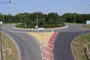
| Simpson Roundabout Pictured | H9 Groveway |
| Mount Farm Roundabout | Bond Avenue |
| Future | |
| Fenny Lock Roundabout | H10 Bletcham Way H10 Bletcham Way The H10 Bletcham Way is a major local road in Milton Keynes, Buckinghamshire. Its formal name is simply "Bletcham Way": the "H10" designation is an urban planning name that indicates that it is the tenth east-west grid road in the Milton Keynes grid road system.... |
External links
- http://www.mkweb.co.uk/_system/_System/_private/MyMap/MKMap/aerialviewoutput.asp?X_Coord=486181&Y_Coord=238909 Aerial photograph of the V8 (top left-bottom right) at its intersection with the H6 Childs Way. You can see the Xscape domeXscape (building)Xscape buildings are large, strikingly designed and unusually shaped buildings. Typically they contain a real snow indoor ski slope, leisure facilities and related shops...
in the left of the photograph.