

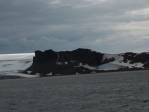
Ustra Peak
Encyclopedia
Walker Bay, Livingston Island
Walker Bay is a bay lying between John Beach and Hannah Point along the south coast of Livingston Island in the South Shetland Islands, Antarctica...
, Livingston Island in the South Shetland Islands
South Shetland Islands
The South Shetland Islands are a group of Antarctic islands, lying about north of the Antarctic Peninsula, with a total area of . By the Antarctic Treaty of 1959, the Islands' sovereignty is neither recognized nor disputed by the signatories and they are free for use by any signatory for...
, Antarctica. The peak was named after the medieval Bulgarian fortress of Ustra
Ustra
Ustra is a castle in the eastern Rhodope Mountains in southern Bulgaria. Its ruins lie southwest of the village of Ustren situated on a hill at approximately above sea level....
in the Eastern Rhodope Mountains
Rhodope Mountains
The Rhodopes are a mountain range in Southeastern Europe, with over 83% of its area in southern Bulgaria and the remainder in Greece. Its highest peak, Golyam Perelik , is the seventh highest Bulgarian mountain...
.
Location
The peak is located at 62°38′26"S 60°35′57"W which is next southeast of Verila GlacierVerila Glacier
Verila Glacier on Livingston Island in the South Shetland Islands, Antarctica is bounded by Rotch Dome to the west, Casanovas Peak and Snow Peak to the north, and Ustra Peak to the southeast...
, 2.1 km west of Krakra Bluff
Krakra Bluff
Krakra Bluff is a rocky bluff of elevation 140 m surmounting Memorable Beach on the northwest coast of South Bay, Livingston Island in the South Shetland Islands, Antarctica...
and 1.71 km north-northeast of Hannah Point
Hannah Point
Hannah Point is a point on the south coast of Livingston Island in the South Shetland Islands, Antarctica. It forms the east side of the entrance to Walker Bay and the west side of the entrance to South Bay. Surmounted by Ustra Peak to the north, with Liverpool Beach extending between the peak and...
. It was mapped by the British in 1968, and by the Bulgarians in 2005 and 2009.
Maps
- L.L. Ivanov et al. Antarctica: Livingston Island and Greenwich Island, South Shetland Islands. Scale 1:100000 topographic map. Sofia: Antarctic Place-names Commission of Bulgaria, 2005.
- L.L. Ivanov. Antarctica: Livingston Island and Greenwich, Robert, Snow and Smith Islands. Scale 1:120000 topographic map. Troyan: Manfred Wörner Foundation, 2009. ISBN 978-954-92032-6-4