

U.S. Route 12 in Indiana
Encyclopedia
In the U.S. state
of Indiana
, U.S. Route 12 is a historical east–west arterial highway that runs along the Lake Michigan
shoreline. In the early 1920s, it was the most important route between Chicago, Illinois and Detroit, Michigan
. Most of the route has since been supplanted by Interstate 94
and the Indiana Toll Road
.
The total length of U.S. 12 in Indiana is approximately 45.16 miles (72.7 km).
In Indiana, the highway has been designated as the Iron Brigade Memorial Highway to honor the Civil War Union Army unit; a designation it also has in Michigan, Wisconsin and Illinois.
. It begins concurrent
with U.S. Route 20
and U.S. Route 41
. In Whiting, U.S. 41 branches south, following the eastern side of Wolf Lake
. U.S. 12/20 continues southeast through a field of Amoco
oil storage tanks. South of the storage tanks, U.S. 20 continues south and turns east south of Interstate 90
(Indiana Toll Road), while U.S. 12 runs east, and then southeast towards the Gary/Chicago International Airport
.
U.S. 12 then runs below the Toll Road at the Little Calumet River. It closely parallels U.S. 20 on the west side of Gary, then joins with it at Bridge Street. Through Gary, U.S. 12/20 runs westbound on 4th Avenue, and eastbound on 5th Avenue. It also has intersections with the Toll Road at Buchanan Street and State Road 53 (Broadway).
East of downtown Gary, U.S. 12/20 has a signalized intersection with the northern terminus of Interstate 65
.
Through this part of northwest Indiana, U.S. 12 consists of four lanes (two westbound, two eastbound), and widens to six lanes when concurrent with U.S. 20.
and Porter
) while U.S. 12 passes through the Indiana Dunes National Lakeshore
and retains the name "Dunes Highway." After splitting from U.S. 20, U.S. 12 has only two lanes, one westbound and one eastbound, although it widens to four lanes between Ogden Dunes
and Burns Harbor
. It intersects State Road 249 and State Road 149 the industrial complex at Burns Harbor, which includes a NIPSCO power plant and a steel mill.
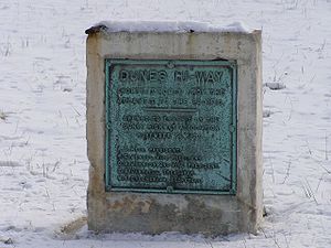
The "Dunes Highway" is the name for a section of Route 12 that is largely located within Porter County, Indiana
. The Dunes Highway begins on the east side of Gary, Indiana
(specifically, Interstate 65
), travels through Portage, Indiana
and ends on the west side of Michigan City, Indiana
one half mile (0.8 km) east of the LaPorte County
line, near Mount Baldy. The Dunes Highway carries U.S. Route 12 near, but not on or within sight of, the shoreline of Lake Michigan
.
This segment of U.S. 12 is about 25 miles (40 km) long. As the predecessor to Interstate 80
, Interstate 90
and Interstate 94
, this segment of road between Detroit, Michigan
and Chicago, Illinois was one of the most important and most heavily traveled roads from 1899 through 1922.
The Dunes Highway is considered the gateway to Lake Michigan's picturesque dune
s of northern Indiana
and western Michigan
. Access is provided to the dunes via the National Park Service
's entrance to West Beach of the Indiana Dunes National Lakeshore
, at the boundary between Lake and Porter counties. The State of Indiana Department of Natural Resources runs Indiana Dunes State Park
, located further east at Indiana State Route 49. East of the State Park, there are additional points of access to the National Lakeshore beaches in and near Beverly Shores
, at Kemil Road, Central Avenue and Mount Baldy.
At Indiana Dunes State Park, U.S. 12 has an interchange with State Road 49. In the Town of Pines
, U.S. 12 intersects with State Road 520, which is the final connecting route to U.S. 20 before the two separate regionally.
In Michigan City, U.S. 12 intersects with the northern terminus of U.S. Route 35
. (This will end in October 2009, when US 35's terminus is moved east to US 20
. The change was approved by AASHTO on October 17, 2008.) Before exiting Indiana, U.S. 12 intersects State Road 212, an eastern bypass of Michigan City, and then travels through Michiana Shores
.
 "One important project was the 1900 to 1910 macadamizing of part of the Old Chicago Road, Northwest Indiana's major auto route between Gary and Michigan City before the Dunes Highway. In a 1954 Chesterton Tribune article, C.W. Nelson noted that a 12 feet (3.7 m)-wide macadam section of the Old Chicago Road was laid after the turn of the century from his Baillytown family farm north of the present U.S. 12 and west of the current Bethlehem Steel entrance gate to earlier sections of pavement at Highway 49. Macadam was the best road surface available for most of the 19th century. However, automobile tires created grooves in macadam roads, which yielded in the 1920s to asphalt and concrete surfacing."
As more cars hit the road the Chicago Motor Club, founded in 1906, began marking what
it considered the best route between Detroit and Chicago. Club members designated what locals referred to as the Old Chicago Road Seven-A-Route to assist drivers without detailed road maps.
They placed signs at intersections to help motorists negotiate Seven-A-Route's many right angle turns. For example, from Oak Hill Road travelers on the Chicago Road proceeded east as far as
"the high bridge" on the present Old S.R. 49, then north to the present U.S. 20, then east to the Carver School Road, then north for a mile, then east to Michigan City. The circuitous road punctuated by numerous grade crossings made driving slow and treacherous. These conditions kindled desires for a more efficient thoroughfare which eventually led to the construction of The Dunes Highway.
Works Projects Administration writers attributed the genesis of the "Dunes Highway" to 1919 government surveys for an improved road along the lakeshore following the old Detroit State Road
route. But Gary Post-Tribune columnist Tom Cannon credited Henry M. Miles, Michigan City engineer, with the idea for a national highway along the South Shore interurban line between Gary and Michigan City. Miles' 1918 speech to the Michigan City Chamber of Commerce, "Trunk Line Highways," appealed to the business community's concerns for more efficient transportation and commerce. Soon Gary Commercial Club members caught Dunes Highway fever. A.H. Hess, chairman of the Commercial Club Good Roads committee, organized the Dunes Highway Association to lobby state highway commission officials for the new road. Representatives from the West Michigan Pike Association and Illinois' Sheridan Drive Association attended the initial January 20, 1919, meeting of the Dunes Highway Association. They saw the Dunes Highway bridging Lake Michigan's western and eastern shores to the straits of Mackinac. Gathering momentum, the Dunes Highway Association launched an intensive public relations campaign assisted by Cannon's Gary Post-Tribune articles.
Dunes Highway Association engineers envisioned the Dunes Highway a "state of the art" 40 feet (12.2 m)-wide concrete highway with a 100 feet (30.5 m) right-of-way. Therefore, the new road would have closely
adhered to proper road design and construction specifications suggested by leading highway engineers for an Ideal Section of the transcontinental Lincoln Highway. Engineers conceived this
transportation innovation after the 1916 passage of the Federal-Aid Road Act. In 1922, the 1⅓-mile Ideal Section was built in Lake County beginning at Dyer on the Illinois-Indiana border. This section of pavement was designed to carry automobiles traveling 35 miles (56.3 km) an hour and motor trucks 10 miles (16.1 km) an hour on average. The State Highway Commission did not accede to the
Dunes Highway Association's wishes for a model road like the Ideal Section. In August 1919, Commission director H.L. Wright tentatively designated the Dunes Highway as State Road 43, to be
20 feet (6.1 m) wide. Narrower than anticipated, the new concrete highway was still superior to most Indiana roads, which in the mid-1920s were gravel or dirt with paved sections only between the larger towns.
Dunes Highway construction began in 1922 under the guidance of Gary contractor Ingwald Moe and construction engineer Ezra Sensibar. Both public and private funding defrayed the approximately $1 million construction cost of the Dunes Highway. The new road qualified under the 1921 Federal Highway Act for matching government funds. This legislation replaced the original Federal-Aid Road Act of 1916 to more stringently restrict the distribution of highway funds. The law required that states earmark for federal funding less than 7 percent of the state's entire highway mileage. Indiana's total road mileage in 1921 was 73131 miles (117,692.6 km). Consequently, only 5000 miles (8,046.7 km) of state roads could receive federal funding. The Hoosier State Automobile Association also claimed responsibility for financing the Dunes Highway, soliciting businesses along the road to support construction. The Michigan City News-Dispatch reported that the local business community paid an $11 membership fee to defray Dunes Highway construction expenses. Realizing the benefits of a road linking regional industries, the Consumers' Company, a sand mining enterprise, and Inland Steel Company donated rights-of-way through their property.
U.S. state
A U.S. state is any one of the 50 federated states of the United States of America that share sovereignty with the federal government. Because of this shared sovereignty, an American is a citizen both of the federal entity and of his or her state of domicile. Four states use the official title of...
of Indiana
Indiana
Indiana is a US state, admitted to the United States as the 19th on December 11, 1816. It is located in the Midwestern United States and Great Lakes Region. With 6,483,802 residents, the state is ranked 15th in population and 16th in population density. Indiana is ranked 38th in land area and is...
, U.S. Route 12 is a historical east–west arterial highway that runs along the Lake Michigan
Lake Michigan
Lake Michigan is one of the five Great Lakes of North America and the only one located entirely within the United States. It is the second largest of the Great Lakes by volume and the third largest by surface area, after Lake Superior and Lake Huron...
shoreline. In the early 1920s, it was the most important route between Chicago, Illinois and Detroit, Michigan
Detroit, Michigan
Detroit is the major city among the primary cultural, financial, and transportation centers in the Metro Detroit area, a region of 5.2 million people. As the seat of Wayne County, the city of Detroit is the largest city in the U.S. state of Michigan and serves as a major port on the Detroit River...
. Most of the route has since been supplanted by Interstate 94
Interstate 94
Interstate 94 is the northernmost east–west Interstate Highway, connecting the Great Lakes and Intermountain regions of the United States. I-94's western terminus is in Billings, Montana at a junction with Interstate 90; its eastern terminus is the U.S...
and the Indiana Toll Road
Indiana Toll Road
The Indiana Toll Road, officially the Indiana East–West Toll Road, is a toll road that runs for east–west across northern Indiana from the Illinois state line to the Ohio state line...
.
The total length of U.S. 12 in Indiana is approximately 45.16 miles (72.7 km).
In Indiana, the highway has been designated as the Iron Brigade Memorial Highway to honor the Civil War Union Army unit; a designation it also has in Michigan, Wisconsin and Illinois.
Whiting to Gary
This portion of U.S. 12 largely consists of industrialized sections of WhitingWhiting, Indiana
Whiting is a city located in the Chicago Metropolitan Area in Lake County, Indiana, which was founded in 1889. The city is located on the southern shore of Lake Michigan. It is roughly 16 miles from the Chicago Loop and just short of two miles from Chicago's South Side. Whiting is home to Whiting...
. It begins concurrent
Concurrency (road)
A concurrency, overlap, or coincidence in a road network is an instance of one physical road bearing two or more different highway, motorway, or other route numbers...
with U.S. Route 20
U.S. Route 20
U.S. Route 20 is an east–west United States highway. As the "0" in its route number implies, US 20 is a coast-to-coast route. Spanning , it is the longest road in the United States, and the route sparsely parallels Interstate 90...
and U.S. Route 41
U.S. Route 41
U.S. Route 41 is a north–south United States Highway that runs from Miami, Florida to the Upper Peninsula of Michigan. Until 1949, the part in southern Florida, from Naples to Miami, was U.S...
. In Whiting, U.S. 41 branches south, following the eastern side of Wolf Lake
Wolf Lake, Indiana/Illinois
Wolf Lake is an lake that straddles the Hammond, Indiana / Chicago, Illinois border. It is smaller than it was prior to settlement by people of European descent because of infilling for development around the edges...
. U.S. 12/20 continues southeast through a field of Amoco
Amoco
Amoco Corporation, originally Standard Oil Company , was a global chemical and oil company, founded in 1889 around a refinery located in Whiting, Indiana, United States....
oil storage tanks. South of the storage tanks, U.S. 20 continues south and turns east south of Interstate 90
Interstate 90
Interstate 90 is the longest Interstate Highway in the United States at . It is the northernmost coast-to-coast interstate, and parallels US 20 for the most part. Its western terminus is in Seattle, at Edgar Martinez Drive S. near Safeco Field and CenturyLink Field, and its eastern terminus is in...
(Indiana Toll Road), while U.S. 12 runs east, and then southeast towards the Gary/Chicago International Airport
Gary/Chicago International Airport
Gary/Chicago International Airport is a public airport located three miles northwest of the central business district of Gary, a city in Lake County, Indiana, United States. The airport, which serves the Chicago metropolitan area, is 25 miles southeast of the Chicago Loop...
.
U.S. 12 then runs below the Toll Road at the Little Calumet River. It closely parallels U.S. 20 on the west side of Gary, then joins with it at Bridge Street. Through Gary, U.S. 12/20 runs westbound on 4th Avenue, and eastbound on 5th Avenue. It also has intersections with the Toll Road at Buchanan Street and State Road 53 (Broadway).
East of downtown Gary, U.S. 12/20 has a signalized intersection with the northern terminus of Interstate 65
Interstate 65
Interstate 65 is a major Interstate Highway in the United States. The southern terminus is located at an intersection with Interstate 10 in Mobile, Alabama, and its northern terminus is at an interchange with Interstate 90 , U.S. Route 12, and U.S...
.
Through this part of northwest Indiana, U.S. 12 consists of four lanes (two westbound, two eastbound), and widens to six lanes when concurrent with U.S. 20.
Gary to Michiana Shores
In the far eastern portion of Gary, U.S. 12/20 split for the final time, although U.S. 20 closely parallels U.S. 12 for the next 20 miles (32 km), sometimes coming within 0.2 miles of intersecting. U.S. 20 follows a slightly more southerly route to Michigan City (via PortagePortage, Indiana
Portage is a city in Portage Township, Porter County, Indiana, United States. The population was 36,828 as of the 2010 census. It is the largest city in Porter County, and third largest in Northwest Indiana.-Geography:...
and Porter
Porter, Indiana
Porter is a town in Westchester Township, Porter County, Indiana, United States. The population was 4,972 at the 2000 census.Porter is noted for its proximity to the Indiana Dunes State Park and for its railroad heritage...
) while U.S. 12 passes through the Indiana Dunes National Lakeshore
Indiana Dunes National Lakeshore
Indiana Dunes National Lakeshore is a U.S. National Lakeshore located in northwest Indiana and managed by the National Park Service. It was authorized by Congress in 1966. The national lakeshore runs for nearly along the southern shore of Lake Michigan, from Gary, Indiana, on the west to Michigan...
and retains the name "Dunes Highway." After splitting from U.S. 20, U.S. 12 has only two lanes, one westbound and one eastbound, although it widens to four lanes between Ogden Dunes
Ogden Dunes, Indiana
Ogden Dunes is a town in Portage Township, Porter County, Indiana, United States. The population was 1,110 at the 2000 census. It is named for Francis A. Ogden, who owned the land there before his death in 1914.-History:...
and Burns Harbor
Burns Harbor, Indiana
Burns Harbor is a town in Westchester Township, Porter County, Indiana, United States on the shores of Lake Michigan in Northwest Indiana and is part of the Chicago metropolitan area...
. It intersects State Road 249 and State Road 149 the industrial complex at Burns Harbor, which includes a NIPSCO power plant and a steel mill.
The "Dunes Highway" is the name for a section of Route 12 that is largely located within Porter County, Indiana
Porter County, Indiana
Porter County is a county located in the U.S. state of Indiana. As of 2010, the population was 164,343. Much of the population growth has to do with the expansion of the Chicago Metropolitan Area eastward into Indiana. The county seat is Valparaiso...
. The Dunes Highway begins on the east side of Gary, Indiana
Gary, Indiana
Gary is a city in Lake County, Indiana, United States. The city is in the southeastern portion of the Chicago metropolitan area and is 25 miles from downtown Chicago. The population is 80,294 at the 2010 census, making it the seventh-largest city in the state. It borders Lake Michigan and is known...
(specifically, Interstate 65
Interstate 65
Interstate 65 is a major Interstate Highway in the United States. The southern terminus is located at an intersection with Interstate 10 in Mobile, Alabama, and its northern terminus is at an interchange with Interstate 90 , U.S. Route 12, and U.S...
), travels through Portage, Indiana
Portage, Indiana
Portage is a city in Portage Township, Porter County, Indiana, United States. The population was 36,828 as of the 2010 census. It is the largest city in Porter County, and third largest in Northwest Indiana.-Geography:...
and ends on the west side of Michigan City, Indiana
Michigan City, Indiana
Michigan City's origins date to 1830, when the land for the city was first purchased by Isaac C. Elston. Elston Middle School, formerly Elston High School, located at 317 Detroit St., is named after the founder....
one half mile (0.8 km) east of the LaPorte County
LaPorte County, Indiana
LaPorte County is a county located in the U.S. state of Indiana. As of 2010, the population was 111,467. The county seat is the city of La Porte. This county is part of the Chicago metropolitan area, Northwest Indiana and Michiana. The largest city is Michigan City...
line, near Mount Baldy. The Dunes Highway carries U.S. Route 12 near, but not on or within sight of, the shoreline of Lake Michigan
Lake Michigan
Lake Michigan is one of the five Great Lakes of North America and the only one located entirely within the United States. It is the second largest of the Great Lakes by volume and the third largest by surface area, after Lake Superior and Lake Huron...
.
This segment of U.S. 12 is about 25 miles (40 km) long. As the predecessor to Interstate 80
Interstate 80
Interstate 80 is the second-longest Interstate Highway in the United States, following Interstate 90. It is a transcontinental artery running from downtown San Francisco, California to Teaneck, New Jersey in the New York City Metropolitan Area...
, Interstate 90
Interstate 90
Interstate 90 is the longest Interstate Highway in the United States at . It is the northernmost coast-to-coast interstate, and parallels US 20 for the most part. Its western terminus is in Seattle, at Edgar Martinez Drive S. near Safeco Field and CenturyLink Field, and its eastern terminus is in...
and Interstate 94
Interstate 94
Interstate 94 is the northernmost east–west Interstate Highway, connecting the Great Lakes and Intermountain regions of the United States. I-94's western terminus is in Billings, Montana at a junction with Interstate 90; its eastern terminus is the U.S...
, this segment of road between Detroit, Michigan
Detroit, Michigan
Detroit is the major city among the primary cultural, financial, and transportation centers in the Metro Detroit area, a region of 5.2 million people. As the seat of Wayne County, the city of Detroit is the largest city in the U.S. state of Michigan and serves as a major port on the Detroit River...
and Chicago, Illinois was one of the most important and most heavily traveled roads from 1899 through 1922.
The Dunes Highway is considered the gateway to Lake Michigan's picturesque dune
Dune
In physical geography, a dune is a hill of sand built by wind. Dunes occur in different forms and sizes, formed by interaction with the wind. Most kinds of dunes are longer on the windward side where the sand is pushed up the dune and have a shorter "slip face" in the lee of the wind...
s of northern Indiana
Indiana
Indiana is a US state, admitted to the United States as the 19th on December 11, 1816. It is located in the Midwestern United States and Great Lakes Region. With 6,483,802 residents, the state is ranked 15th in population and 16th in population density. Indiana is ranked 38th in land area and is...
and western Michigan
Michigan
Michigan is a U.S. state located in the Great Lakes Region of the United States of America. The name Michigan is the French form of the Ojibwa word mishigamaa, meaning "large water" or "large lake"....
. Access is provided to the dunes via the National Park Service
National Park Service
The National Park Service is the U.S. federal agency that manages all national parks, many national monuments, and other conservation and historical properties with various title designations...
's entrance to West Beach of the Indiana Dunes National Lakeshore
Indiana Dunes National Lakeshore
Indiana Dunes National Lakeshore is a U.S. National Lakeshore located in northwest Indiana and managed by the National Park Service. It was authorized by Congress in 1966. The national lakeshore runs for nearly along the southern shore of Lake Michigan, from Gary, Indiana, on the west to Michigan...
, at the boundary between Lake and Porter counties. The State of Indiana Department of Natural Resources runs Indiana Dunes State Park
Indiana Dunes State Park
Indiana DunesDesignationState Park; National Natural LandmarkLocationPorter County, Indiana, USAAddress1600 N 25 EChesterton, IN 46304Nearest CityPorter, IndianaCoordinatesAreaDate of Establishment1925...
, located further east at Indiana State Route 49. East of the State Park, there are additional points of access to the National Lakeshore beaches in and near Beverly Shores
Beverly Shores, Indiana
Beverly Shores is a town in Pine Township, Porter County, Indiana, United States, about east of downtown Chicago. The population was 613 at the 2010 census.-History:...
, at Kemil Road, Central Avenue and Mount Baldy.
At Indiana Dunes State Park, U.S. 12 has an interchange with State Road 49. In the Town of Pines
Town of Pines, Indiana
Town of Pines is a town in Pine Township, Porter County, Indiana, United States. The population was 708 at the 2010 census.-Geography:Town of Pines is located at ....
, U.S. 12 intersects with State Road 520, which is the final connecting route to U.S. 20 before the two separate regionally.
In Michigan City, U.S. 12 intersects with the northern terminus of U.S. Route 35
U.S. Route 35
U.S. Route 35 is a north–south United States highway that runs northwest-southeast for approximately from northern Indiana to the western suburbs of Charleston, West Virginia. The highway's northern terminus is in Michigan City, Indiana, at U.S. Route 20. Its southern terminus is in Scott...
. (This will end in October 2009, when US 35's terminus is moved east to US 20
U.S. Route 20
U.S. Route 20 is an east–west United States highway. As the "0" in its route number implies, US 20 is a coast-to-coast route. Spanning , it is the longest road in the United States, and the route sparsely parallels Interstate 90...
. The change was approved by AASHTO on October 17, 2008.) Before exiting Indiana, U.S. 12 intersects State Road 212, an eastern bypass of Michigan City, and then travels through Michiana Shores
Michiana Shores, Indiana
Michiana Shores is a town in Springfield and Michigan townships, LaPorte County, Indiana, United States. The population was 313 at the 2010 census. It is included in the Michigan City, Indiana-La Porte, Indiana Metropolitan Statistical Area...
.
History of the Dunes Highway
As more cars hit the road the Chicago Motor Club, founded in 1906, began marking what
it considered the best route between Detroit and Chicago. Club members designated what locals referred to as the Old Chicago Road Seven-A-Route to assist drivers without detailed road maps.
They placed signs at intersections to help motorists negotiate Seven-A-Route's many right angle turns. For example, from Oak Hill Road travelers on the Chicago Road proceeded east as far as
"the high bridge" on the present Old S.R. 49, then north to the present U.S. 20, then east to the Carver School Road, then north for a mile, then east to Michigan City. The circuitous road punctuated by numerous grade crossings made driving slow and treacherous. These conditions kindled desires for a more efficient thoroughfare which eventually led to the construction of The Dunes Highway.
Works Projects Administration writers attributed the genesis of the "Dunes Highway" to 1919 government surveys for an improved road along the lakeshore following the old Detroit State Road
route. But Gary Post-Tribune columnist Tom Cannon credited Henry M. Miles, Michigan City engineer, with the idea for a national highway along the South Shore interurban line between Gary and Michigan City. Miles' 1918 speech to the Michigan City Chamber of Commerce, "Trunk Line Highways," appealed to the business community's concerns for more efficient transportation and commerce. Soon Gary Commercial Club members caught Dunes Highway fever. A.H. Hess, chairman of the Commercial Club Good Roads committee, organized the Dunes Highway Association to lobby state highway commission officials for the new road. Representatives from the West Michigan Pike Association and Illinois' Sheridan Drive Association attended the initial January 20, 1919, meeting of the Dunes Highway Association. They saw the Dunes Highway bridging Lake Michigan's western and eastern shores to the straits of Mackinac. Gathering momentum, the Dunes Highway Association launched an intensive public relations campaign assisted by Cannon's Gary Post-Tribune articles.
Dunes Highway Association engineers envisioned the Dunes Highway a "state of the art" 40 feet (12.2 m)-wide concrete highway with a 100 feet (30.5 m) right-of-way. Therefore, the new road would have closely
adhered to proper road design and construction specifications suggested by leading highway engineers for an Ideal Section of the transcontinental Lincoln Highway. Engineers conceived this
transportation innovation after the 1916 passage of the Federal-Aid Road Act. In 1922, the 1⅓-mile Ideal Section was built in Lake County beginning at Dyer on the Illinois-Indiana border. This section of pavement was designed to carry automobiles traveling 35 miles (56.3 km) an hour and motor trucks 10 miles (16.1 km) an hour on average. The State Highway Commission did not accede to the
Dunes Highway Association's wishes for a model road like the Ideal Section. In August 1919, Commission director H.L. Wright tentatively designated the Dunes Highway as State Road 43, to be
20 feet (6.1 m) wide. Narrower than anticipated, the new concrete highway was still superior to most Indiana roads, which in the mid-1920s were gravel or dirt with paved sections only between the larger towns.
Dunes Highway construction began in 1922 under the guidance of Gary contractor Ingwald Moe and construction engineer Ezra Sensibar. Both public and private funding defrayed the approximately $1 million construction cost of the Dunes Highway. The new road qualified under the 1921 Federal Highway Act for matching government funds. This legislation replaced the original Federal-Aid Road Act of 1916 to more stringently restrict the distribution of highway funds. The law required that states earmark for federal funding less than 7 percent of the state's entire highway mileage. Indiana's total road mileage in 1921 was 73131 miles (117,692.6 km). Consequently, only 5000 miles (8,046.7 km) of state roads could receive federal funding. The Hoosier State Automobile Association also claimed responsibility for financing the Dunes Highway, soliciting businesses along the road to support construction. The Michigan City News-Dispatch reported that the local business community paid an $11 membership fee to defray Dunes Highway construction expenses. Realizing the benefits of a road linking regional industries, the Consumers' Company, a sand mining enterprise, and Inland Steel Company donated rights-of-way through their property.