

U.S. Route 10 in Wisconsin
Encyclopedia
In the U.S. state
of Wisconsin
, U.S. Route 10
(normally called U.S. Highway 10, Highway 10 or US 10) runs east–west across the central part of the state. It runs from the Prescott Drawbridge over the St. Croix River at Prescott, where it enters Minnesota
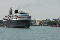
, east to the dock in Manitowoc where the Lake Michigan Carferry (SS Badger) crosses Lake Michigan
to Ludington, Michigan
.
from Minnesota at Prescott and immediately joins with WIS 35 north. WIS 35 turns north 1 miles (1.6 km) northeast at WIS 29 while US 10 continues east and passes through Ellsworth
at the junctions with WIS 65 and US 63 The highway turns southeast and passes through Ono
and Plum City
. US 10 then enters Pepin County
and junctions with WIS 25 and WIS 85 at Durand
US 10 briefly enters Buffalo County
and passes through Mondovi
at the junction with WIS 37. In northern Trempealeau County
, the highway crosses WIS 93 at Eleva
, passes through Strum
, and junctions with US 53 and I-94
in Osseo
. The route then enters Jackson County
where it joins US 12
and WIS 27. US 12 and WIS 27 split to the south at the Clark County line while US 10 continues east to Neillsville
and crosses WIS 73 there. The highway then meanders northeast into Wood County, passing south of Marshfield
and crossing WIS 13. US 10 then passes through the community of Auburndale
and enters Portage County
at Milladore
.
US 10 meets WIS 34 north at two miles (3 km) west of Junction City
. WIS 34 splits north two miles (3 km) east of Junction City while US 10 turns east and bypasses Stevens Point
on a new freeway. In Stevens Point, the old US 10 has been replaced by WIS 66 which travels through downtown and near the University of Wisconsin–Stevens Point
just east of downtown. The highway then meets I-39
/ US 51
north of the city and runs concurrent with I-39
/ US 51
for about seven miles before exiting to the east of Stevens Point. At this point, US 10 becomes a multilane expressway and heads southeast, passing through Amherst and crossing into Waupaca County
. US 10 bypasses the city of Waupaca
to the south and junctions with WIS 22, WIS 54 and meets WIS 49 south. US 10 and WIS 49 turn eastward to Weyauwega
then head south to Fremont
where WIS 49 turns south and US 10 becomes a freeway at the junction with WIS 110. US 10 collects US 45
south in northwest Winnebago County
for a three mile (5 km) southeast trek before US 45 splits to the south and US 10 turns east to rendezvous with WIS 441 at the junction with US 41
in Neenah
. US 10 turns south off the WIS 441 freeway south of Appleton
and turns east into Calumet County
.
As a multilane urban arterial, US 10 collects WIS 114 for four miles (6 km) before the latter splits south two miles (3 km) before US 10 junctions with WIS 55. The highway then crosses WIS 32 and WIS 57 at Forest Junction
and turns southeast to pass through Brillion
and into Manitowoc County
. The highway passes through Reedsville
and Whitelaw
before turning south onto I-43
for three miles (5 km) and turning east off the Interstate to head along WIS 42 into the north side of Manitowoc
. US 10 then turns south into downtown where it continues into Michigan
via the S.S. Badger
carferry to Ludington
.
 Prior to 1926, what is now US 10 was State Trunk Highway 18. However, Highway 18 initially (in 1917) only ran from Humbird
, near where US 10 and U.S. Highway 12 (then State Trunk Highway 12) cross, east to Manitowoc. State Trunk Highway 34 ran from Prescott to Highway 37
in Mondovi. The route between Mondovi and Humbird was not numbered until the early 1920s, when Highway 18 was extended west from Humbird past Mondovi to Prescott, eliminating Highway 34.
When US 10 was designated in late 1926, it ran along U.S. Highway 12 from Minnesota east to Humbird, splitting there to run to Manitowoc. The piece of former Highway 18 west of Humbird became Highway 34, as the number 18 conflicted with U.S. Highway 18. In 1934, Highway 34 disappeared again, as US 10 was separated from the US 12 concurrency
to run along it.
This project will complete US-10 as four lanes facility from Marshfield to Menasha, a project started in the late 1990s. The only segment of the highway not a divided expressway will be from I-39 in Stevens Point to CTH-J.
U.S. state
A U.S. state is any one of the 50 federated states of the United States of America that share sovereignty with the federal government. Because of this shared sovereignty, an American is a citizen both of the federal entity and of his or her state of domicile. Four states use the official title of...
of Wisconsin
Wisconsin
Wisconsin is a U.S. state located in the north-central United States and is part of the Midwest. It is bordered by Minnesota to the west, Iowa to the southwest, Illinois to the south, Lake Michigan to the east, Michigan to the northeast, and Lake Superior to the north. Wisconsin's capital is...
, U.S. Route 10
U.S. Route 10
U.S. Route 10 is an east–west United States highway formed in 1926. Though it never became the cross-country highway suggested by the "0" as the last digit of its route number, U.S...
(normally called U.S. Highway 10, Highway 10 or US 10) runs east–west across the central part of the state. It runs from the Prescott Drawbridge over the St. Croix River at Prescott, where it enters Minnesota
Minnesota
Minnesota is a U.S. state located in the Midwestern United States. The twelfth largest state of the U.S., it is the twenty-first most populous, with 5.3 million residents. Minnesota was carved out of the eastern half of the Minnesota Territory and admitted to the Union as the thirty-second state...
, east to the dock in Manitowoc where the Lake Michigan Carferry (SS Badger) crosses Lake Michigan
Lake Michigan
Lake Michigan is one of the five Great Lakes of North America and the only one located entirely within the United States. It is the second largest of the Great Lakes by volume and the third largest by surface area, after Lake Superior and Lake Huron...
to Ludington, Michigan
Ludington, Michigan
Ludington is a city in the U.S. state of Michigan. As of the 2000 census, the city population was 8,357. It is the county seat of Mason County.Ludington is a harbor town located on Lake Michigan at the mouth of the Pere Marquette River...
.
Route description
U.S. Highway 10 enters the state and Pierce CountyPierce County, Wisconsin
Pierce County is a county located in the U.S. state of Wisconsin. As of 2010, the population was 41,019. Its county seat is Ellsworth. Pierce County is part of the Minneapolis-St. Paul-Bloomington, MN-WI Metropolitan Statistical Area .-Geography:...
from Minnesota at Prescott and immediately joins with WIS 35 north. WIS 35 turns north 1 miles (1.6 km) northeast at WIS 29 while US 10 continues east and passes through Ellsworth
Ellsworth, Wisconsin
Ellsworth is a village in Pierce County, Wisconsin, United States. The population was 3,284 at the 2010 census. The village is located within the Town of Ellsworth...
at the junctions with WIS 65 and US 63 The highway turns southeast and passes through Ono
Ono, Wisconsin
Ono is an unincorporated community located in the towns of Salem and Union, Pierce County, Wisconsin, United States. Ono is located at the junction of U.S. Route 10 and County Highway CC west-northwest of Plum City....
and Plum City
Plum City, Wisconsin
Plum City is a village in Pierce County, Wisconsin, United States. The population was 574 at the 2000 census.-Education:Plum City, as of 2009, has an Elementary School, Middle School, and High School...
. US 10 then enters Pepin County
and junctions with WIS 25 and WIS 85 at Durand
Durand, Wisconsin
Durand is a city in Pepin County, Wisconsin, United States. The population was 1,968 at the 2000 census. The city is located within the Town of Durand and is also the county seat....
US 10 briefly enters Buffalo County
Buffalo County, Wisconsin
Buffalo County is a county located in the U.S. state of Wisconsin. As of 2000, the population was 13,804. Its county seat is Alma.-Geography:According to the U.S...
and passes through Mondovi
Mondovi, Wisconsin
Mondovi is a city in Buffalo County in the U.S. state of Wisconsin, along the Buffalo River. The population was 2,634 at the 2000 census. The city is located mostly within the Town of Mondovi...
at the junction with WIS 37. In northern Trempealeau County
Trempealeau County, Wisconsin
Trempealeau County is a county located in the U.S. state of Wisconsin. As of 2009, the population estimate was 27,754. Its county seat is Whitehall.-History:Patches of woodland are all that remain of the brush and light forest that once covered the county...
, the highway crosses WIS 93 at Eleva
Eleva, Wisconsin
Eleva is a village in Trempealeau County, Wisconsin, along the Buffalo River. The population was 670 at the 2010 census.-History:The village was originally named "New Chicago". The grain elevator had the letters "ELEVA" painted on it before winter struck...
, passes through Strum
Strum, Wisconsin
Strum is a village in Trempealeau County, Wisconsin, along the Buffalo River. The population was 1,001 at the 2000 census.-Geography:Strum is located at ....
, and junctions with US 53 and I-94
Interstate 94
Interstate 94 is the northernmost east–west Interstate Highway, connecting the Great Lakes and Intermountain regions of the United States. I-94's western terminus is in Billings, Montana at a junction with Interstate 90; its eastern terminus is the U.S...
in Osseo
Osseo, Wisconsin
Osseo is a city located in Trempealeau County, Wisconsin, at the confluence of the North and South Forks of the Buffalo River. As of the 2000 census, the city had a total population of 1,669.-Geography:...
. The route then enters Jackson County
Jackson County, Wisconsin
Jackson County is a county located in the U.S. state of Wisconsin. As of 2009, the population estimate was 19,886. Its county seat is Black River Falls. Jackson County was formed from Crawford County in 1853.-Geography:According to the U.S...
where it joins US 12
U.S. Route 12 in Wisconsin
In the U.S. state of Wisconsin, U.S. Route 12 runs east–west across the western to southeast portions of the state...
and WIS 27. US 12 and WIS 27 split to the south at the Clark County line while US 10 continues east to Neillsville
Neillsville, Wisconsin
Neillsville is a city in Clark County in the U.S. state of Wisconsin. The population was 2,731 at the 2000 census. It is the county seat.-Geography:Neillsville is located at ....
and crosses WIS 73 there. The highway then meanders northeast into Wood County, passing south of Marshfield
Marshfield, Wisconsin
Marshfield is a city in Marathon and Wood counties in the U.S. state of Wisconsin. It is the largest city in Wood County. The small portion of the city that extends into Marathon County is part of the Wausau Metropolitan Statistical Area. The population was 18,800 at the 2000 census. Marshfield is...
and crossing WIS 13. US 10 then passes through the community of Auburndale
Auburndale, Wisconsin
Auburndale is a village in Wood County, Wisconsin, United States. The population was 738 at the 2000 census.-History:Auburndale was established in 1872 by Robert Connor, father of William D...
and enters Portage County
Portage County, Wisconsin
Portage County is a county in the U.S. state of Wisconsin. As of 2000, the population was 67,182. Its county seat is Stevens Point. The United States Census Bureau's Stevens Point Micropolitan Statistical Area includes all of Portage County.-Geography:...
at Milladore
Milladore, Wisconsin
Milladore is a village in Portage and Wood Counties in the U.S. state of Wisconsin. The population was 268 at the 2000 census. Most of the village is located within the Town of Milladore in Wood County, while only a very small portion of the village lies in Portage County.-Geography:Milladore is...
.
US 10 meets WIS 34 north at two miles (3 km) west of Junction City
Junction City, Wisconsin
Junction City is a village in Portage County, Wisconsin, United States. The population was 440 at the 2000 census.-Geography:Junction City is located at ....
. WIS 34 splits north two miles (3 km) east of Junction City while US 10 turns east and bypasses Stevens Point
Stevens Point, Wisconsin
Stevens Point is the county seat of Portage County, Wisconsin, United States. Located in the central part of the state, it is the largest city in the county, with a population of 24,551 at the 2000 census...
on a new freeway. In Stevens Point, the old US 10 has been replaced by WIS 66 which travels through downtown and near the University of Wisconsin–Stevens Point
University of Wisconsin–Stevens Point
The University of Wisconsin–Stevens Point is a public university located in Stevens Point, Wisconsin...
just east of downtown. The highway then meets I-39
Interstate 39
Interstate 39 is a highway in the midwestern United States. I-39 runs from Normal, Illinois at Interstate 55 to Highway 29 in Rothschild, Wisconsin, approximately six miles south of Wausau. I-39 was designed to replace US Highway 51, which in the early 1980s was one of the busiest two-lane...
/ US 51
U.S. Route 51 in Wisconsin
In the U.S. state of Wisconsin, U.S. Route 51 runs north–south down the central part of the state...
north of the city and runs concurrent with I-39
Interstate 39
Interstate 39 is a highway in the midwestern United States. I-39 runs from Normal, Illinois at Interstate 55 to Highway 29 in Rothschild, Wisconsin, approximately six miles south of Wausau. I-39 was designed to replace US Highway 51, which in the early 1980s was one of the busiest two-lane...
/ US 51
U.S. Route 51 in Wisconsin
In the U.S. state of Wisconsin, U.S. Route 51 runs north–south down the central part of the state...
for about seven miles before exiting to the east of Stevens Point. At this point, US 10 becomes a multilane expressway and heads southeast, passing through Amherst and crossing into Waupaca County
Waupaca County, Wisconsin
-Demographics: As of the census of 2000, there were 51,731 people, 19,863 households, and 13,884 families residing in the county. The population density was . There were 22,508 housing units at an average density of...
. US 10 bypasses the city of Waupaca
Waupaca, Wisconsin
Waupaca is a city in Waupaca County in the state of Wisconsin. The population was 5,676 at the 2000 census. The city is believed to be named after Sam Waupaca of the Potowatomi tribe....
to the south and junctions with WIS 22, WIS 54 and meets WIS 49 south. US 10 and WIS 49 turn eastward to Weyauwega
Weyauwega, Wisconsin
Weyauwega is a city in Waupaca County, Wisconsin, United States. The population was 1,806 at the 2000 census. The city is located mostly within the Town of Weyauwega, though it is politically independent. Small portions extend north into the adjacent Town of Royalton...
then head south to Fremont
Fremont, Wisconsin
Fremont is a village in Waupaca County, Wisconsin, United States, within the town of Fremont. The population was 666 at the 2000 census. Fremont is often referred to as the "White Bass Capital of the World."-Geography:...
where WIS 49 turns south and US 10 becomes a freeway at the junction with WIS 110. US 10 collects US 45
U.S. Route 45 in Wisconsin
In the U.S. state of Wisconsin, U.S. Route 45 runs north–south through the eastern and northern portions of the state.-Route description:...
south in northwest Winnebago County
Winnebago County, Wisconsin
Winnebago County is a county in the U.S. state of Wisconsin. As of 2009, the population estimate was 163,370. Its county seat is Oshkosh. Winnebago County is included in the Oshkosh, Wisconsin-Neenah, Wisconsin, Metropolitan Statistical Area.-Geography:...
for a three mile (5 km) southeast trek before US 45 splits to the south and US 10 turns east to rendezvous with WIS 441 at the junction with US 41
U.S. Route 41 in Wisconsin
In the U.S. state of Wisconsin, U.S. Highway 41 runs north–south the eastern side of the state. It enters from Illinois at Pleasant Prairie, and runs north to its northern terminus at the Michigan border at Marinette, WI.-Route description:US-41 is a freeway for nearly 70% of its route...
in Neenah
Neenah, Wisconsin
Neenah is a city on Lake Winnebago in Winnebago County, Wisconsin, United States. Its population was 24,507 at the 2000 census. The city is bordered by, but is politically independent of, the Town of Neenah. Neenah is the southwestern-most of the Fox Cities of Northeast Wisconsin...
. US 10 turns south off the WIS 441 freeway south of Appleton
Appleton, Wisconsin
Appleton is a city in Outagamie, Calumet, and Winnebago Counties in the U.S. state of Wisconsin. It is situated on the Fox River, 30 miles southwest of Green Bay and 100 miles north of Milwaukee. Appleton is the county seat of Outagamie County. The population was 78,086 at the 2010 census...
and turns east into Calumet County
Calumet County, Wisconsin
Calumet County is a county located in the U.S. state of Wisconsin. It is included in the Appleton, Wisconsin, Metropolitan Statistical Area. As of 2010, the county's population was 48,971. The county seat is Chilton.-History:...
.
As a multilane urban arterial, US 10 collects WIS 114 for four miles (6 km) before the latter splits south two miles (3 km) before US 10 junctions with WIS 55. The highway then crosses WIS 32 and WIS 57 at Forest Junction
Forest Junction, Wisconsin
Forest Junction is an unincorporated census-designated place in the Town of Brillion, in Calumet County, Wisconsin in the United States. As of the 2010 census, its population was 616.The community has its own water tower and utilities. Its ZIP code is 54123....
and turns southeast to pass through Brillion
Brillion, Wisconsin
Brillion is a city in Calumet County in the U.S. state of Wisconsin. The population was 2,937 at the 2000 census. The city is located within the Town of Brillion, though it is politically independent.-Notable residents:...
and into Manitowoc County
Manitowoc County, Wisconsin
Manitowoc County is a county in the U.S. state of Wisconsin. As of 2000, the population was 82,887. Its county seat is Manitowoc. The United States Census Bureau's Manitowoc Micropolitan Statistical Area includes all of Manitowoc County.-Government:...
. The highway passes through Reedsville
Reedsville, Wisconsin
Reedsville is a village in Manitowoc County, Wisconsin, United States. The population was 1,187 at the 2000 census.-History:The village was named after Judge George Reed, who, with his partner, Jacob Lueps, bought a section of land in the town of Maple Grove, Wisconsin. In 1854, they had the land...
and Whitelaw
Whitelaw, Wisconsin
Whitelaw is a village in Manitowoc County, Wisconsin, United States. The population was 730 at the 2000 census.-Geography:Whitelaw is located at ....
before turning south onto I-43
Interstate 43
Interstate 43 is a intrastate Interstate Highway located entirely within the U.S. state of Wisconsin, connecting Interstate 39 and Interstate 90 in Beloit with Milwaukee and U.S. Route 41 and U.S. Route 141 in Green Bay. I-43 is the 5th longest intrastate Interstate Highway of the Interstate...
for three miles (5 km) and turning east off the Interstate to head along WIS 42 into the north side of Manitowoc
Manitowoc, Wisconsin
Manitowoc is a city in and the county seat of Manitowoc County, Wisconsin, United States. The city is located on Lake Michigan at the mouth of the Manitowoc River. According to the 2000 census, Manitowoc had a population of 34,053, with over 50,000 residents in the surrounding communities...
. US 10 then turns south into downtown where it continues into Michigan
Michigan
Michigan is a U.S. state located in the Great Lakes Region of the United States of America. The name Michigan is the French form of the Ojibwa word mishigamaa, meaning "large water" or "large lake"....
via the S.S. Badger
S.S. Badger
The SS Badger is a coal-fired passenger and vehicle ferry in the United States that has been in Lake Michigan service from 1953 until the present. Currently, she shuttles between Ludington, Michigan and Manitowoc, Wisconsin. She is the last coal-fired passenger vessel operating on the Great...
carferry to Ludington
Ludington, Michigan
Ludington is a city in the U.S. state of Michigan. As of the 2000 census, the city population was 8,357. It is the county seat of Mason County.Ludington is a harbor town located on Lake Michigan at the mouth of the Pere Marquette River...
.
History
Humbird, Wisconsin
Humbird is an unincorporated census-designated place located in Clark County, Wisconsin, United States. Humbird is located on U.S. Route 12 north-northwest of Merrillan, in the town of Mentor. Humbird has a post office with ZIP code 54746...
, near where US 10 and U.S. Highway 12 (then State Trunk Highway 12) cross, east to Manitowoc. State Trunk Highway 34 ran from Prescott to Highway 37
Highway 37 (Wisconsin)
State Trunk Highway 37 is a state highway in the U.S. state of Wisconsin. It runs generally south-southwesterly through west-central Wisconsin from Eau Claire to Alma. The southern , from Mondovi to Alma, generally follows the course of the Buffalo River....
in Mondovi. The route between Mondovi and Humbird was not numbered until the early 1920s, when Highway 18 was extended west from Humbird past Mondovi to Prescott, eliminating Highway 34.
When US 10 was designated in late 1926, it ran along U.S. Highway 12 from Minnesota east to Humbird, splitting there to run to Manitowoc. The piece of former Highway 18 west of Humbird became Highway 34, as the number 18 conflicted with U.S. Highway 18. In 1934, Highway 34 disappeared again, as US 10 was separated from the US 12 concurrency
Concurrency (road)
A concurrency, overlap, or coincidence in a road network is an instance of one physical road bearing two or more different highway, motorway, or other route numbers...
to run along it.
Minnesota Border to Stevens Point
Stevens Point to Appleton
| County | Location | Mile | # Exit number An exit number is a number assigned to a road junction, usually an exit from a freeway. It is usually marked on the same sign as the destinations of the exit, as well as a sign in the gore.... |
Destinations | Notes |
|---|---|---|---|---|---|
| Portage Portage County, Wisconsin Portage County is a county in the U.S. state of Wisconsin. As of 2000, the population was 67,182. Its county seat is Stevens Point. The United States Census Bureau's Stevens Point Micropolitan Statistical Area includes all of Portage County.-Geography:... |
Stevens Point Stevens Point, Wisconsin Stevens Point is the county seat of Portage County, Wisconsin, United States. Located in the central part of the state, it is the largest city in the county, with a population of 24,551 at the 2000 census... |
179.94 | at I-39 Exit 158 | ||
| Stockton Stockton, Wisconsin Stockton is a town in Portage County, Wisconsin, United States. The population was 2,896 at the 2000 census. The unincorporated communities of Arnott, Custer, Fancher, Esker, and Stockton are located in Stockton.-Geography:... |
183.95 | ||||
| Custer Custer, Wisconsin Custer is an unincorporated community in Portage County, Wisconsin, United States.-History:The origin of the communities name is not confirmed but a genereal consensus is it was named after Lt. Col. George Armstrong Custer, who was defeated during the battle of the Little Big Horn in 1876... |
188.50 | At-grade intersection  follow follow  East East |
|||
| Stockton Stockton, Wisconsin Stockton is a town in Portage County, Wisconsin, United States. The population was 2,896 at the 2000 census. The unincorporated communities of Arnott, Custer, Fancher, Esker, and Stockton are located in Stockton.-Geography:... |
191.2 | At-grade intersection | |||
| 191.9 | At-grade intersection | ||||
| Amherst Junction Amherst Junction, Wisconsin Amherst Junction is a village in Portage County, Wisconsin, United States. The population was 305 at the 2000 census.-History:Amherst Junction was created when the railroad first came through the county... |
190.94 | Amherst Jct, Lake Dr | Eastbound exit; Westbound entrance only | ||
| Amherst Amherst, Wisconsin Amherst is a village in Portage County, Wisconsin, United States. As of 2009 the population was 1052 people. Amherst creates the core of the Tomorrow valley area.-History:... |
192.51 |   follow East follow East |
|||
| 194.51 | |||||
| Waupaca Waupaca County, Wisconsin -Demographics: As of the census of 2000, there were 51,731 people, 19,863 households, and 13,884 families residing in the county. The population density was . There were 22,508 housing units at an average density of... |
Sheridan Sheridan, Wisconsin Sheridan is a town in Dunn County, Wisconsin, United States. The population was 483 at the 2000 census.-Geography:According to the United States Census Bureau, the town has a total area of 36.1 square miles , of which, 36.1 square miles of it is land and 0.03% is... |
200.89 | At-grade intersection | ||
| Waupaca Waupaca, Wisconsin Waupaca is a city in Waupaca County in the state of Wisconsin. The population was 5,676 at the 2000 census. The city is believed to be named after Sam Waupaca of the Potowatomi tribe.... |
204.69 |   follow East follow East |
|||
| 205.97 | King King, Waupaca County, Wisconsin -External links:*... - this exit   follow East follow East |
||||
| 207.38 | Churchill St | ||||
| 208.66 | |||||
| Weyauwega Weyauwega, Wisconsin Weyauwega is a city in Waupaca County, Wisconsin, United States. The population was 1,806 at the 2000 census. The city is located mostly within the Town of Weyauwega, though it is politically independent. Small portions extend north into the adjacent Town of Royalton... |
213.95 |  follow East follow East |
|||
| 214.92 | Westbound exit, Eastbound entrance only | ||||
| Fremont Fremont, Wisconsin Fremont is a village in Waupaca County, Wisconsin, United States, within the town of Fremont. The population was 666 at the 2000 census. Fremont is often referred to as the "White Bass Capital of the World."-Geography:... |
218.73 | ||||
| 221.77 | |||||
| Winnebago Winnebago County, Wisconsin Winnebago County is a county in the U.S. state of Wisconsin. As of 2009, the population estimate was 163,370. Its county seat is Oshkosh. Winnebago County is included in the Oshkosh, Wisconsin-Neenah, Wisconsin, Metropolitan Statistical Area.-Geography:... |
Winchester Winchester, Winnebago County, Wisconsin Winchester is a town in Winnebago County, Wisconsin, United States. The population was 1,676 at the 2000 census. The census-designated place of Winchester is located in the town... |
228.02 | Western terminus of Concurrency | ||
| 230.59 | Eastern terminus of Concurrency | ||||
| Neenah Neenah, Wisconsin Neenah is a city on Lake Winnebago in Winnebago County, Wisconsin, United States. Its population was 24,507 at the 2000 census. The city is bordered by, but is politically independent of, the Town of Neenah. Neenah is the southwestern-most of the Fox Cities of Northeast Wisconsin... |
238.10 | Eastbound also signed To US-41 North | |||
| 240.54 | |||||
| 241.68 | Western terminus of Concurrency | ||||
| 241.68 | Eastbound - No access to US 41 North | ||||
| Westbound | |||||
| Menasha Menasha, Wisconsin Menasha is a city in Calumet and Winnebago Counties in the U.S. state of Wisconsin. The population was 16,331 at the 2000 census. The city is located mostly in the Town of Menasha in Winnebago County; only a small portion is in the Town of Harrison in Calumet County. Doty Island is located... |
242.64 | ||||
| 243.75 | |||||
| 244.91 | |||||
| Calumet Calumet County, Wisconsin Calumet County is a county located in the U.S. state of Wisconsin. It is included in the Appleton, Wisconsin, Metropolitan Statistical Area. As of 2010, the county's population was 48,971. The county seat is Chilton.-History:... |
Waverly Beach Waverly Beach, Wisconsin Waverly Beach is an unincorporated community located in Calumet and Winnebago Counties, United States. The Calumet County portion of Waverly Beach is located in the town of Harrison, while the Winnebago County portion is in the town of Menasha. Waverly Beach is located on the north shore of Lake... |
245.91 |  follow follow  South South |
||
Appleton to Manitowoc
Current status
WisDOT is in the process of relocating US-10 out of Stevens Point by joining it with I-39 north to the CTH-X interchange. US-10 will then turn west, bypassing smaller communities and end at WIS 13 south of Marshfield. Construction began in 2007 and will finish in 2012.This project will complete US-10 as four lanes facility from Marshfield to Menasha, a project started in the late 1990s. The only segment of the highway not a divided expressway will be from I-39 in Stevens Point to CTH-J.
See also
- U.S. Route 110, a short and short-lived spur from Fremont to Oshkosh