
Twmpa
Encyclopedia
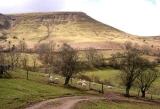
Twmpa or Lord Hereford's Knob is a mountain in south-east Wales
, forming a part of the great northwest scarp
of the Black Mountains
. It lies 3 km west of the border with England, and around 7 km south of Hay-on-Wye
. To the northeast lies the Gospel Pass
through which runs a minor road between Hay and the Llanthony Valley
. A ridge known as Darren Lwyd tapers away for about 3km to the southeast of the summit.
"Lord Hereford's Knob" is the title of a song on Half Man Half Biscuit's
2008 album CSI: Ambleside
. The lyrics feature the grid reference of the mountain.
and mudstone
dating from the Devonian
period and ascribed to the Lower Old Red Sandstone
. Its lower slopes are formed from the mudstone-dominated St Maughans Formation whilst the upper part of the hill is composed of sandstone-dominated Senni Formation rocks. At the junction between the two is a prominent calcrete known as the Ffynnon Limestone.
Numerous landslips have occurred within the St Maughans Formation around the flanks of the hill.
under the CRoW Act and is therefore available for walkers to roam freely across. It is almost encircled by public bridleways and restricted byways. The most well-used track is that running west from Gospel Pass (where car parking is available), over its summit and then southwest towards Rhos Dirion
. A further track runs the length of the ridge southeastwards to the hamlet of Capel-y-ffin
.
Wales
Wales is a country that is part of the United Kingdom and the island of Great Britain, bordered by England to its east and the Atlantic Ocean and Irish Sea to its west. It has a population of three million, and a total area of 20,779 km²...
, forming a part of the great northwest scarp
Scarp
-Landforms and geology:* Cliff, a significant vertical, or near vertical, rock exposure* Escarpment, a steep slope or long cliff that occurs from erosion or faulting and separates two relatively level areas of differing elevations...
of the Black Mountains
Black Mountains, Wales
The Black Mountains are a group of hills spread across parts of Powys and Monmouthshire in southeast Wales, and extending across the national border into Herefordshire, England. They are the easternmost of the four ranges of hills that comprise the Brecon Beacons National Park, and are frequently...
. It lies 3 km west of the border with England, and around 7 km south of Hay-on-Wye
Hay-on-Wye
Hay-on-Wye , often described as "the town of books", is a small market town and community in Powys, Wales.-Location:The town lies on the east bank of the River Wye and is within the Brecon Beacons National Park, just north of the Black Mountains...
. To the northeast lies the Gospel Pass
Vale of Ewyas
The Vale of Ewyas is the steeply-sided and secluded valley of the Afon Honddu, in the Black Mountains of south Wales and within the Brecon Beacons National Park. As well as its outstanding beauty, it is known for the ruins of Llanthony Priory, and for several noteworthy churches such as those at...
through which runs a minor road between Hay and the Llanthony Valley
Vale of Ewyas
The Vale of Ewyas is the steeply-sided and secluded valley of the Afon Honddu, in the Black Mountains of south Wales and within the Brecon Beacons National Park. As well as its outstanding beauty, it is known for the ruins of Llanthony Priory, and for several noteworthy churches such as those at...
. A ridge known as Darren Lwyd tapers away for about 3km to the southeast of the summit.
"Lord Hereford's Knob" is the title of a song on Half Man Half Biscuit's
Half Man Half Biscuit
Half Man Half Biscuit, often "HMHB", are an English rock band from Birkenhead, Merseyside, active since the mid-1980s, known for satirical, sardonic, and sometimes surreal songs. The group comprises Nigel Blackwell , Neil Crossley , Ken Hancock , and Carl Henry...
2008 album CSI: Ambleside
CSI:Ambleside
CSI:Ambleside is the eleventh album by UK rock band Half Man Half Biscuit, released in April 2008.The "CSI" in the title is a reference to the CSI franchise, whilst Ambleside is a small town in northern England.-Track listing:...
. The lyrics feature the grid reference of the mountain.
Geology
In common with neighbouring hills, Twmpa is composed of alternate layers of sandstoneSandstone
Sandstone is a sedimentary rock composed mainly of sand-sized minerals or rock grains.Most sandstone is composed of quartz and/or feldspar because these are the most common minerals in the Earth's crust. Like sand, sandstone may be any colour, but the most common colours are tan, brown, yellow,...
and mudstone
Mudstone
Mudstone is a fine grained sedimentary rock whose original constituents were clays or muds. Grain size is up to 0.0625 mm with individual grains too small to be distinguished without a microscope. With increased pressure over time the platey clay minerals may become aligned, with the...
dating from the Devonian
Devonian
The Devonian is a geologic period and system of the Paleozoic Era spanning from the end of the Silurian Period, about 416.0 ± 2.8 Mya , to the beginning of the Carboniferous Period, about 359.2 ± 2.5 Mya...
period and ascribed to the Lower Old Red Sandstone
Old Red Sandstone
The Old Red Sandstone is a British rock formation of considerable importance to early paleontology. For convenience the short version of the term, 'ORS' is often used in literature on the subject.-Sedimentology:...
. Its lower slopes are formed from the mudstone-dominated St Maughans Formation whilst the upper part of the hill is composed of sandstone-dominated Senni Formation rocks. At the junction between the two is a prominent calcrete known as the Ffynnon Limestone.
Numerous landslips have occurred within the St Maughans Formation around the flanks of the hill.
Access
The entire hill is classed as open countryOpen Country
Open Country is a designation used for some UK access land.It was first defined under the 1949 National Parks Act , and was land over which an appropriate access agreement had been made...
under the CRoW Act and is therefore available for walkers to roam freely across. It is almost encircled by public bridleways and restricted byways. The most well-used track is that running west from Gospel Pass (where car parking is available), over its summit and then southwest towards Rhos Dirion
Rhos Dirion
Rhos Dirion is a top of Waun Fach in the Black Mountains in south-eastern Wales. It is the highest point on the Rhos Dirion - Chwarel y Fan ridge....
. A further track runs the length of the ridge southeastwards to the hamlet of Capel-y-ffin
Capel-y-ffin
Capel-y-ffin is a hamlet near the English-Welsh border in Powys, Wales, in the Black Mountains within the Brecon Beacons National Park. The nearest town is Hay-on-Wye, some to the north-west.-The Chapel:...
.