

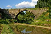
Tsujun Bridge
Encyclopedia
Aqueduct
An aqueduct is a water supply or navigable channel constructed to convey water. In modern engineering, the term is used for any system of pipes, ditches, canals, tunnels, and other structures used for this purpose....
in Yamato
Yamato, Kumamoto
is a town located in Kamimashiki District, Kumamoto, Japan.The town was formed on February 11, 2005 from the merger of the municipalities of Yabe and Seiwa with the town of Soyō from Aso District....
, Kumamoto, Japan
Japan
Japan is an island nation in East Asia. Located in the Pacific Ocean, it lies to the east of the Sea of Japan, China, North Korea, South Korea and Russia, stretching from the Sea of Okhotsk in the north to the East China Sea and Taiwan in the south...
. It is an arch bridge
Arch bridge
An arch bridge is a bridge with abutments at each end shaped as a curved arch. Arch bridges work by transferring the weight of the bridge and its loads partially into a horizontal thrust restrained by the abutments at either side...
completed in 1854 and is 84.0m long. The arch spans 27.3m. It is the largest stone aqueduct in Japan.
The Japanese Agency for Cultural Affairs
Agency for Cultural Affairs
The is a special body of the Japanese Ministry of Education . It was set up in 1968 to promote Japanese arts and culture. As of April 2007, it is led by the Commissioner for Cultural Affairs, Tamotsu Aoki....
has designated the bridge an Important Cultural Property
Important Cultural Properties of Japan
The term is often shortened into just are items officially already classified as Tangible Cultural Properties of Japan by the Japanese Agency for Cultural Affairs and judged to be of particular importance to the Japanese people....
.
History and Technology
- This bridge proves the high level of stone bridge technology at that time.
- Yasunosuke FutaYasunosuke FutaYasunosuke Futa was a village chief and also an architect in Kumamoto Prefecture, Japan. He built Tsujun Bridge, which enriched previously barren land. Futa was later enshrined in Futa Shrine in 1937.-History:At age 23, Futa became acting village chief by birth...
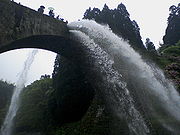
(1801–1873), who was the head of the then Yabe village, planned and after funding, with the help of the group of 41 stone technicians and many farmers, succeeded in building the bridge in 1854. Its purpose was to let water flow into a higher area (Shiroito Plateau) for farming. - After placing wooden frames, stones were placed on the frames, and three stone aqueducts were made. After that, the wooden frames were removed. Because the aqueducts were lower than the upper part of the waterway by 6 meters, a reversed siphon mechanism works when man lets water flow through the aqueducts. The stone aqueducts were made watertight with mortar. The bridge was completed in 1854.
- In order to keep the aqueducts in a perfect condition, and for viewers such as tourists, water is poured into the river once in a while. It is a great show. See the second photograph discharging water.
See also
- History of Kumamoto PrefectureHistory of Kumamoto PrefectureThe outline of the history of Kumamoto Prefecture is described herein. Kumamoto Prefecture is an eastern half of Hinokuni , corresponding to the Higo Province as called in days gone by. Exceptions are the part of Kuma gun or Kuma Districts of Japan which had once been included in Sagara Domain and...