
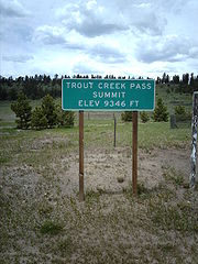
Trout Creek Pass
Encyclopedia
Mountain pass
A mountain pass is a route through a mountain range or over a ridge. If following the lowest possible route, a pass is locally the highest point on that route...
located in the Rocky Mountains
Rocky Mountains
The Rocky Mountains are a major mountain range in western North America. The Rocky Mountains stretch more than from the northernmost part of British Columbia, in western Canada, to New Mexico, in the southwestern United States...
of south-central Colorado
Colorado
Colorado is a U.S. state that encompasses much of the Rocky Mountains as well as the northeastern portion of the Colorado Plateau and the western edge of the Great Plains...
in the United States
United States
The United States of America is a federal constitutional republic comprising fifty states and a federal district...
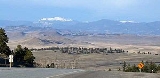
. The pass sits atop the southern end of the Mosquito Range
Mosquito Range
The Mosquito Range is a high mountain range in the Rocky Mountains of central Colorado in the United States. The peaks of the range form a ridge running north-south for approximately 40 miles from southern Summit County on the north end, then along the boundary between Lake and Park counties...
on the Park
Park County, Colorado
Park County is the 17th most extensive of the 64 counties of the State of Colorado of the United States. The county was named after the large geographic region known as South Park, which was named by early fur traders and trappers in the area. The geographic center of the State of Colorado is...
-Chaffee
Chaffee County, Colorado
Chaffee County is one of the 64 counties of the state of Colorado of the United States. The county population was 16,242 at U.S. Census 2000. The county seat is Salida.-History:...
county line, between South Park
South Park (Colorado basin)
South Park is a high intermontane grassland basin, approximately 10,000 ft in elevation, in the Rocky Mountains of central Colorado. It encompasses approximately 1,000 square miles around the headwaters of the South Platte River in Park County approximately 60 mi southwest of Denver...
(the headwaters of the South Platte River
South Platte River
The South Platte River is one of the two principal tributaries of the Platte River and itself a major river of the American Midwest and the American Southwest/Mountain West, located in the U.S. states of Colorado and Nebraska...
to the east) and the headwaters of the Arkansas River
Arkansas River
The Arkansas River is a major tributary of the Mississippi River. The Arkansas generally flows to the east and southeast as it traverses the U.S. states of Colorado, Kansas, Oklahoma, and Arkansas. The river's initial basin starts in the Western United States in Colorado, specifically the Arkansas...
to the west. It is traversed jointly by U.S. Highway 24 (between Hartsel
Hartsel, Colorado
Hartsel is an unincorporated town and a U.S. Post Office located in Park County, Colorado, United States. Hartsel was founded in 1880. Located at the geographic center of the state, it is often referred to as "The Heart of Colorado". The community's namesake is Samuel Hartsel, a local cattle...
and Buena Vista
Buena Vista, Colorado
Buena Vista is a Statutory Town in Chaffee County, Colorado, United States. The population was 2,195 at the 2000 census.Buena Vista is located in central Colorado roughly midway between Salida and Leadville in the Upper Arkansas River Valley at an elevation of . The area between Buena Vista and...
) and U.S. Highway 285 (between Fairplay
Fairplay, Colorado
The Town of Fairplay is a statutory town that is the county seat and the most populous town of Park County, Colorado, United States. Fairplay is located in South Park at an elevation of . The town is the fifth-highest incorporated place in the State of Colorado. The population was 610 at the...
and Buena Vista). It is passable by most motorized vehicles and is closed only during severe winter storms. The approach from the north is mild, while the south side has a moderate 5% grade.
Geologically
Geology
Geology is the science comprising the study of solid Earth, the rocks of which it is composed, and the processes by which it evolves. Geology gives insight into the history of the Earth, as it provides the primary evidence for plate tectonics, the evolutionary history of life, and past climates...
, the pass is located on a fault that runs along the Mosquito Range. Road cuts along the eastern approach to the pass reveal Pennsylvanian
Pennsylvanian
The Pennsylvanian is, in the ICS geologic timescale, the younger of two subperiods of the Carboniferous Period. It lasted from roughly . As with most other geochronologic units, the rock beds that define the Pennsylvanian are well identified, but the exact date of the start and end are uncertain...
black shale
Shale
Shale is a fine-grained, clastic sedimentary rock composed of mud that is a mix of flakes of clay minerals and tiny fragments of other minerals, especially quartz and calcite. The ratio of clay to other minerals is variable. Shale is characterized by breaks along thin laminae or parallel layering...
and thin gray limestone
Limestone
Limestone is a sedimentary rock composed largely of the minerals calcite and aragonite, which are different crystal forms of calcium carbonate . Many limestones are composed from skeletal fragments of marine organisms such as coral or foraminifera....
layers that were laid down prior to the creation of the Ancestral Rockies. These Paleozoic
Paleozoic
The Paleozoic era is the earliest of three geologic eras of the Phanerozoic eon, spanning from roughly...
layers were not uplifted during the creation of the Ancestral Rockies approximately 300 MYA and thus were not eroded to the same degree as other areas to the east and west.
The pass was traversed by the Denver, South Park and Pacific Railroad
Denver, South Park and Pacific Railroad
The Denver, South Park, and Pacific Railroad was a historic narrow gauge railway that operated in Colorado in the western United States in the late 19th century. The railroad opened up the first rail routes to a large section of the central Colorado mining district in the decades of the mineral boom...
in 1879, providing the first rail link between Denver
Denver, Colorado
The City and County of Denver is the capital and the most populous city of the U.S. state of Colorado. Denver is a consolidated city-county, located in the South Platte River Valley on the western edge of the High Plains just east of the Front Range of the Rocky Mountains...
and Leadville
Leadville, Colorado
Leadville is a Statutory City that is the county seat of, and the only municipality in, Lake County, Colorado, United States. Situated at an elevation of , Leadville is the highest incorporated city and the second highest incorporated municipality in the United States...
in the early days of the Colorado Silver Boom
Colorado Silver Boom
The Colorado Silver Boom was a dramatic expansionist period of silver mining activity in the U.S. state of Colorado in the late 19th century. The boom started in 1879 with the discovery of silver at Leadville...
. The Colorado Midland also built a line west from Colorado Springs to Leadville over Trout Creek Pass in the 1890s. Both lines were disused from the 1920s.
The pass is in San Isabel National Forest
San Isabel National Forest
San Isabel National Forest is located in central Colorado. The forest contains 19 of the state's 54 fourteeners, peaks over high, including Mount Elbert, the highest point in Colorado....
.
External links
- Topographic map from USGS The National Map
- Photos of Trout Creek Pass region