
Treaty of Mount Dexter
Encyclopedia
United States
The United States of America is a federal constitutional republic comprising fifty states and a federal district...
and the Choctaws. The treaty was signed November 16, 1805. The 4142720 acres (16,765 km²) area ceded was from the Natchez
Natchez
Natchez may refer to:* Natchez people, a Native American nation* Natchez language, the language of that Native American tribe* Natchez, Mississippi, United States* Natchez, Louisiana, United States* Natchez, Indiana, United States...
District to the Tombigbee Alabama River
Tombigbee River
The Tombigbee River is a tributary of the Mobile River, approximately 200 mi long, in the U.S. states of Mississippi and Alabama. It is one of two major rivers, along with the Alabama River, that unite to form the short Mobile River before it empties into Mobile Bay on the Gulf of Mexico...
watershed, mostly in present-day Mississippi
Mississippi
Mississippi is a U.S. state located in the Southern United States. Jackson is the state capital and largest city. The name of the state derives from the Mississippi River, which flows along its western boundary, whose name comes from the Ojibwe word misi-ziibi...
.
Terms
The preamble begins with,1. Cession to the United States. Reservation.
2. Consideration.
3. Payment to certain Indians for past services.
4. Claim of John M'Grew.
5. Boundaries.
6. A certain former grant confirmed.
7. When to take effect.
Significance
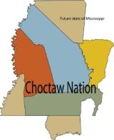
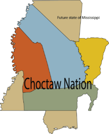
This treaty conveyed large amountsof land in what is now southeastern Mississippi
Mississippi
Mississippi is a U.S. state located in the Southern United States. Jackson is the state capital and largest city. The name of the state derives from the Mississippi River, which flows along its western boundary, whose name comes from the Ojibwe word misi-ziibi...
and southwestern Alabama
Alabama
Alabama is a state located in the southeastern region of the United States. It is bordered by Tennessee to the north, Georgia to the east, Florida and the Gulf of Mexico to the south, and Mississippi to the west. Alabama ranks 30th in total land area and ranks second in the size of its inland...
,
including much of the western portion of Clarke County, Alabama
Clarke County, Alabama
-2010:Whereas according to the 2010 U.S. Census Bureau:*54.5% White*43.9% Black*0.4% Native American*0.3% Asian*0.0% Native Hawaiian or Pacific Islander*0.7% Two or more races*1.0% Hispanic or Latino -2000:...
, to
the United States.
In February, 1809, a survey was begun to establish the actual boundary
lines between the United States and the Choctaw Nation. The United States
contracted with Silas Dinsmoor and Levin Wailes for this survey.
Signatories
The main signers included James Robertson, Silas Dinsmoor, PukshunnubbeeApuckshunubbee
Apuckshunubbee was one of three principal chiefs of the Choctaw Native American tribe in the early nineteenth century, from before 1800. He led the western or Okla Falaya District in present-day Mississippi...
, Mingo Hoomastubbee, and Pushmataha
Pushmataha
Pushmataha , the "Indian General", was one of the three regional chiefs of the major divisions of the Choctaw in the nineteenth century. Many historians considered him the "greatest of all Choctaw chiefs"...
.
See also
- List of Choctaw Treaties
- Treaty of HopewellTreaty of HopewellThe Treaty of Hopewell is any of three different treaties signed at Hopewell Plantation. The plantation was owned by Andrew Pickens, and was located on the Seneca River in northwestern South Carolina. The treaties were signed between the Confederation Congress of the United States of America and...
- Treaty of Fort AdamsTreaty of Fort AdamsThe Treaty of Fort Adams was signed on December 17, 1801 between the Choctaw and the United States Government. The treaty ceded about of Choctaw land...
- Treaty of Fort ConfederationTreaty of Fort ConfederationThe Treaty of Fort Confederation was signed on October 17, 1802 between the Choctaw and the United States Government. The treaty ceded about of Choctaw land, including the site of Fort Tombecbe, also known as Fort Confederation....
- Treaty of Hoe BuckintoopaTreaty of Hoe BuckintoopaThe Treaty of Hoe Buckintoopa was signed on August 31, 1803 between the Choctaw and the United States Government. The treaty ceded about of Choctaw land.-Terms:The preamble begins with,1...
- Treaty of Fort St. StephensTreaty of Fort St. StephensThe Treaty of Fort St. Stephens or Treaty of Choctaw Trading House was signed between the United States and the Choctaws. The treaty was signed at the Choctaw trading house on October 24, 1816. It ceded of Choctaw land east of the Tombigbee River. The land was exchanged for 6,000 US dollars...
- Treaty of Doak's StandTreaty of Doak's StandThe Treaty of Doak's Stand was signed on October 18, 1820 between the United States and the Choctaw Indian tribe. Based on the terms of the accord, the Choctaw agreed to give up approximately one-half of their remaining Choctaw homeland...
- Treaty of Washington CityTreaty of Washington CityThe Treaty of Washington City was a treaty signed on January 20, 1825 between the Choctaw and the United States Government.-Overview:...
- Treaty of Dancing Rabbit CreekTreaty of Dancing Rabbit CreekThe Treaty of Dancing Rabbit Creek was a treaty signed on September 27, 1830 between the Choctaw and the United States Government. This was the first removal treaty carried into effect under the Indian Removal Act...
- List of treaties
- Choctaw CornerChoctaw CornerThe Choctaw Corner is a former Native American boundary location near the modern border between Clarke and Marengo counties in Alabama, United States. It was established as the northernmost terminus for a mutually agreed upon boundary line between the Choctaw and Creek peoples during the...