
Timnath, Colorado
Encyclopedia
The Town of Timnath is a Statutory Town located in Larimer County
, Colorado
, United States
. Founded in 1882, Timnath is a small agricultural/farming
community located southeast of Fort Collins, Colorado
, approximately one-half mile east of the Harmony Road/Interstate 25 interchange, on a small bluff east of the Cache la Poudre River
. The surrounding farmlands have been used primarily for potato
es, alfalfa
, sugar beet
s, and cattle
. Although the town has remained virtually unchanged in recent decades, the encroaching growth of both Fort Collins to the west and Windsor
to the south have placed the town in an area considered favorable to development. The population was 223 at the 2000 census
.
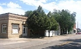
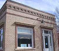
), a one-story modern post-office, and several other historic buildings. Most residences are single-family homes.
 The area was first homesteaded
by white settlers in 1869. The first schoolhouse was constructed that year, approximately one-half mile west of the current town, and was named "Fairview". By 1880, the community had outgrown the schoolhouse, and new "Fairview" school was built just north of the current town. The school also served as an early meeting place for the Presbyterian Church. The turning point in the early history of the community was in 1882, with the arrival of the Greeley, Salt Lake and Pacific Railroad
(controlled by the Union Pacific) linking Greeley
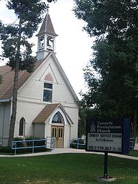
and Fort Collins. The following year, the Presbyterian Church, petitioned by local residents, sent a missionary to found a congregation. The current structure along Main Street dates from that year.
A post office was established in 1884, headed by Reverend Charles A. Taylor, the local Presbyterian minister. When the post office was formed, Taylor bestowed the current name of the town from the 14th chapter of the Book of Judges
, as the place where Samson
went to obtain a Philistine
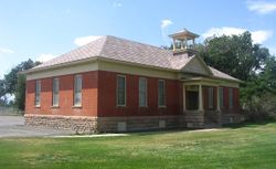
wife. In 1900 the second school became outdated and a new one was built, dropping the name "Fairview" permanently. This structure currently stands as an out-building to the current elementary school. A larger school was built in 1918 (which burned in 1935 and was rebuilt the following year). The school district was consolidated with that of Fort Collins in 1960.
During WWII Japan experimented with "Balloon Bombs" that floated across the pacific to the U.S. One of these bombs dropped and exploded near Timnath, Colorado making it the only continental U.S. town to bombed by a foreign country.
According to the United States Census Bureau
, as of the 2000 census, the town has a total area of 0.2 square mile (0.517997622 km²), of which, 0.2 square mile (0.517997622 km²) of it is land and none of it is covered by water.
The historical downtown lies along County Road Five, which runs north-south parallel to Interstate 25 half a mile to the east (Existing Land Use Map). Since the 2000 census, the town of Timnath has annexed several square miles of land to the east and southeast; the town Future Land Use Plan anticipates commercial development along the east-west corridor of County Road 38 (Harmony Road). The majority of the six mile (north-south) by three mile (east-west) block of land that lies within Timnath's growth management area is low-density residential or agricultural, and is designated to remain so, with open space and parkland filling the remainder of the area, particularly near the Poudre River and Timnath Reservoir.
 Timnath is a Home Rule Town, governed by a Town Council, which consists of five elected officials - one Mayor and four Council Members, all positions are elected "at large," meaning that candidates come from all areas of the town. Elected officials serve 4 year terms.
Council meetings are open, public meetings where the Council makes town decisions and creates local laws and policies. The Council holds regular meetings on the first and third Wednesday of each month at 7 p.m. Unless otherwise noted, all meetings are held at Town Hall at 4100 Main Street. The Council holds work sessions on the second Wednesday of each month at 6 p.m. Unless otherwise noted, these meetings are also held at Town Hall.
The Town Council appoints the Town Manager who is responsible for the administration and daily operations of the Town.
Police services are provided by the Larimer County Sheriff's Department. Fire protection is provided by volunteer firefighters operating out of a fire station that is supported by the Poudre Fire Authority.
of 2000, there were 223 people, 88 households, and 62 families residing in the town. The population density
was 960.2 people per square mile (374.4/km²). There were 91 housing units at an average density of 391.8 per square mile (152.8/km²). The racial makeup of the town was 91.93% White, 0.00% African American, 3.14% Native American, 0.00% Asian, 0.00% Pacific Islander, 0.45% from other races, and 4.48% from two or more races. 8.07% of the population were Hispanic or Latino of any race.
There were 88 households out of which 34.1% had children under the age of 18 living with them, 56.8% were married couples
living together, 5.7% had a female householder with no husband present, and 29.5% were non-families. 22.7% of all households were made up of individuals and 6.8% had someone living alone who was 65 years of age or older. The average household size was 2.53 and the average family size was 3.03.
In the town the population was spread out with 30.5% under the age of 18, 0.9% from 18 to 24, 35.9% from 25 to 44, 25.6% from 45 to 64, and 7.2% who were 65 years of age or older. The median age was 39 years. For every 100 females there were 95.6 males. For every 100 females age 18 and over, there were 98.7 males.
The median income for a household in the town was $51,250, and the median income for a family was $55,000. Males had a median income of $41,250 versus $29,375 for females. The per capita income
for the town was $27,089. 10.5% of the population and 7.7% of families were below the poverty line. 11.6% of those under the age of 18 and 0.0% of those 65 and older were living below the poverty line.
Larimer County, Colorado
Larimer County is the seventh most populous and the ninth most extensive of the 64 counties of the State of Colorado of the United States. The county is located at the northern end of the Front Range, at the edge of the Colorado Eastern Plains along the border with Wyoming...
, Colorado
Colorado
Colorado is a U.S. state that encompasses much of the Rocky Mountains as well as the northeastern portion of the Colorado Plateau and the western edge of the Great Plains...
, United States
United States
The United States of America is a federal constitutional republic comprising fifty states and a federal district...
. Founded in 1882, Timnath is a small agricultural/farming
Agriculture
Agriculture is the cultivation of animals, plants, fungi and other life forms for food, fiber, and other products used to sustain life. Agriculture was the key implement in the rise of sedentary human civilization, whereby farming of domesticated species created food surpluses that nurtured the...
community located southeast of Fort Collins, Colorado
Fort Collins, Colorado
Fort Collins is a Home Rule Municipality situated on the Cache La Poudre River along the Colorado Front Range, and is the county seat and most populous city of Larimer County, Colorado, United States. Fort Collins is located north of the Colorado State Capitol in Denver. With a 2010 census...
, approximately one-half mile east of the Harmony Road/Interstate 25 interchange, on a small bluff east of the Cache la Poudre River
Cache La Poudre River
The Cache la Poudre River is in the state of Colorado in the United States.Its headwaters are in the Front Range in Larimer County, in the northern part of Rocky Mountain National Park. The river descends eastward in the mountains through the Roosevelt National Forest in Poudre Canyon...
. The surrounding farmlands have been used primarily for potato
Potato
The potato is a starchy, tuberous crop from the perennial Solanum tuberosum of the Solanaceae family . The word potato may refer to the plant itself as well as the edible tuber. In the region of the Andes, there are some other closely related cultivated potato species...
es, alfalfa
Alfalfa
Alfalfa is a flowering plant in the pea family Fabaceae cultivated as an important forage crop in the US, Canada, Argentina, France, Australia, the Middle East, South Africa, and many other countries. It is known as lucerne in the UK, France, Australia, South Africa and New Zealand, and known as...
, sugar beet
Sugar beet
Sugar beet, a cultivated plant of Beta vulgaris, is a plant whose tuber contains a high concentration of sucrose. It is grown commercially for sugar production. Sugar beets and other B...
s, and cattle
Cattle
Cattle are the most common type of large domesticated ungulates. They are a prominent modern member of the subfamily Bovinae, are the most widespread species of the genus Bos, and are most commonly classified collectively as Bos primigenius...
. Although the town has remained virtually unchanged in recent decades, the encroaching growth of both Fort Collins to the west and Windsor
Windsor, Colorado
The Town of Windsor is a Home Rule Municipality in Larimer and Weld counties in the U.S. state of Colorado. According to the 2010 Census, the population of the town was 18,644. Windsor is located in the region known as Northern Colorado. Windsor is situated north of the Colorado State Capitol in...
to the south have placed the town in an area considered favorable to development. The population was 223 at the 2000 census
United States Census, 2000
The Twenty-second United States Census, known as Census 2000 and conducted by the Census Bureau, determined the resident population of the United States on April 1, 2000, to be 281,421,906, an increase of 13.2% over the 248,709,873 persons enumerated during the 1990 Census...
.
Description
Other structures lining Main Street (a section of County Road 5) include an elementary school (in the Poudre School DistrictPoudre School District
The Poudre School District is K-12 public school district in Larimer County in northern Colorado. The district operates and manages the public schools in the city of Fort Collins, as well as in the towns of Wellington and Timnath, and unincorporated communities of Larimer County including Laporte...
), a one-story modern post-office, and several other historic buildings. Most residences are single-family homes.
History
Homesteading
Broadly defined, homesteading is a lifestyle of simple self-sufficiency.-Current practice:The term may apply to anyone who follows the back-to-the-land movement by adopting a sustainable, self-sufficient lifestyle. While land is no longer freely available in most areas of the world, homesteading...
by white settlers in 1869. The first schoolhouse was constructed that year, approximately one-half mile west of the current town, and was named "Fairview". By 1880, the community had outgrown the schoolhouse, and new "Fairview" school was built just north of the current town. The school also served as an early meeting place for the Presbyterian Church. The turning point in the early history of the community was in 1882, with the arrival of the Greeley, Salt Lake and Pacific Railroad
Greeley, Salt Lake and Pacific Railroad
The Greeley, Salt Lake and Pacific Railway was a railroad that operated in northern Colorado in the United States during the 1880s. Founded with heavy backing with the Union Pacific Railroad, it was controlled by the Union Pacific from its inception, but was incorporated into the new Colorado and...
(controlled by the Union Pacific) linking Greeley
Greeley, Colorado
The City of Greeley is a Home Rule Municipality that is the county seat and the most populous city of Weld County, Colorado, United States. Greeley is located in the region known as Northern Colorado. Greeley is situated north-northeast of the Colorado State Capitol in Denver. According to the...
and Fort Collins. The following year, the Presbyterian Church, petitioned by local residents, sent a missionary to found a congregation. The current structure along Main Street dates from that year.
A post office was established in 1884, headed by Reverend Charles A. Taylor, the local Presbyterian minister. When the post office was formed, Taylor bestowed the current name of the town from the 14th chapter of the Book of Judges
Book of Judges
The Book of Judges is the seventh book of the Hebrew bible and the Christian Old Testament. Its title describes its contents: it contains the history of Biblical judges, divinely inspired prophets whose direct knowledge of Yahweh allows them to act as decision-makers for the Israelites, as...
, as the place where Samson
Samson
Samson, Shimshon ; Shamshoun or Sampson is the third to last of the Judges of the ancient Israelites mentioned in the Tanakh ....
went to obtain a Philistine
Philistines
Philistines , Pleshet or Peleset, were a people who occupied the southern coast of Canaan at the beginning of the Iron Age . According to the Bible, they ruled the five city-states of Gaza, Askelon, Ashdod, Ekron and Gath, from the Wadi Gaza in the south to the Yarqon River in the north, but with...
wife. In 1900 the second school became outdated and a new one was built, dropping the name "Fairview" permanently. This structure currently stands as an out-building to the current elementary school. A larger school was built in 1918 (which burned in 1935 and was rebuilt the following year). The school district was consolidated with that of Fort Collins in 1960.
During WWII Japan experimented with "Balloon Bombs" that floated across the pacific to the U.S. One of these bombs dropped and exploded near Timnath, Colorado making it the only continental U.S. town to bombed by a foreign country.
Geography
Timnath is located at 40°31'47" North, 104°58'54" West (40.529718, -104.981654).According to the United States Census Bureau
United States Census Bureau
The United States Census Bureau is the government agency that is responsible for the United States Census. It also gathers other national demographic and economic data...
, as of the 2000 census, the town has a total area of 0.2 square mile (0.517997622 km²), of which, 0.2 square mile (0.517997622 km²) of it is land and none of it is covered by water.
The historical downtown lies along County Road Five, which runs north-south parallel to Interstate 25 half a mile to the east (Existing Land Use Map). Since the 2000 census, the town of Timnath has annexed several square miles of land to the east and southeast; the town Future Land Use Plan anticipates commercial development along the east-west corridor of County Road 38 (Harmony Road). The majority of the six mile (north-south) by three mile (east-west) block of land that lies within Timnath's growth management area is low-density residential or agricultural, and is designated to remain so, with open space and parkland filling the remainder of the area, particularly near the Poudre River and Timnath Reservoir.
Government
Council meetings are open, public meetings where the Council makes town decisions and creates local laws and policies. The Council holds regular meetings on the first and third Wednesday of each month at 7 p.m. Unless otherwise noted, all meetings are held at Town Hall at 4100 Main Street. The Council holds work sessions on the second Wednesday of each month at 6 p.m. Unless otherwise noted, these meetings are also held at Town Hall.
The Town Council appoints the Town Manager who is responsible for the administration and daily operations of the Town.
Police services are provided by the Larimer County Sheriff's Department. Fire protection is provided by volunteer firefighters operating out of a fire station that is supported by the Poudre Fire Authority.
Demographics
As of the censusCensus
A census is the procedure of systematically acquiring and recording information about the members of a given population. It is a regularly occurring and official count of a particular population. The term is used mostly in connection with national population and housing censuses; other common...
of 2000, there were 223 people, 88 households, and 62 families residing in the town. The population density
Population density
Population density is a measurement of population per unit area or unit volume. It is frequently applied to living organisms, and particularly to humans...
was 960.2 people per square mile (374.4/km²). There were 91 housing units at an average density of 391.8 per square mile (152.8/km²). The racial makeup of the town was 91.93% White, 0.00% African American, 3.14% Native American, 0.00% Asian, 0.00% Pacific Islander, 0.45% from other races, and 4.48% from two or more races. 8.07% of the population were Hispanic or Latino of any race.
There were 88 households out of which 34.1% had children under the age of 18 living with them, 56.8% were married couples
Marriage
Marriage is a social union or legal contract between people that creates kinship. It is an institution in which interpersonal relationships, usually intimate and sexual, are acknowledged in a variety of ways, depending on the culture or subculture in which it is found...
living together, 5.7% had a female householder with no husband present, and 29.5% were non-families. 22.7% of all households were made up of individuals and 6.8% had someone living alone who was 65 years of age or older. The average household size was 2.53 and the average family size was 3.03.
In the town the population was spread out with 30.5% under the age of 18, 0.9% from 18 to 24, 35.9% from 25 to 44, 25.6% from 45 to 64, and 7.2% who were 65 years of age or older. The median age was 39 years. For every 100 females there were 95.6 males. For every 100 females age 18 and over, there were 98.7 males.
The median income for a household in the town was $51,250, and the median income for a family was $55,000. Males had a median income of $41,250 versus $29,375 for females. The per capita income
Per capita income
Per capita income or income per person is a measure of mean income within an economic aggregate, such as a country or city. It is calculated by taking a measure of all sources of income in the aggregate and dividing it by the total population...
for the town was $27,089. 10.5% of the population and 7.7% of families were below the poverty line. 11.6% of those under the age of 18 and 0.0% of those 65 and older were living below the poverty line.
See also
- Colorado municipalitiesColorado municipalitiesThe U.S. state of Colorado currently has 271 active incorporated municipalities, including 196 towns, 73 cities, and two consolidated city and county governments.-Municipal government:...
- Fort Collins-Loveland Metropolitan Statistical AreaFort Collins-Loveland Metropolitan Statistical AreaThe Fort Collins-Loveland Metropolitan Statistical Area is a United States Census Bureau defined Metropolitan Statistical Area located in the Fort Collins and Loveland region of the U.S. state of Colorado. The Fort Collins-Loveland MSA is defined as Larimer County, Colorado. The Census Bureau...
- Front Range Urban CorridorFront Range Urban CorridorThe Front Range Urban Corridor is an oblong region of urban population located along the eastern face of the Southern Rocky Mountains in the U.S. states of Colorado and Wyoming. The corridor derives its name from the Front Range, the mountain range that defines the west central boundary of the...
- Larimer County, ColoradoLarimer County, ColoradoLarimer County is the seventh most populous and the ninth most extensive of the 64 counties of the State of Colorado of the United States. The county is located at the northern end of the Front Range, at the edge of the Colorado Eastern Plains along the border with Wyoming...
- State of Colorado