

Fort Collins-Loveland Metropolitan Statistical Area
Encyclopedia
United States Census Bureau
The United States Census Bureau is the government agency that is responsible for the United States Census. It also gathers other national demographic and economic data...
defined Metropolitan Statistical Area (MSA)
United States metropolitan area
In the United States a metropolitan statistical area is a geographical region with a relatively high population density at its core and close economic ties throughout the area. Such regions are not legally incorporated as a city or town would be, nor are they legal administrative divisions like...
located in the Fort Collins
Fort Collins, Colorado
Fort Collins is a Home Rule Municipality situated on the Cache La Poudre River along the Colorado Front Range, and is the county seat and most populous city of Larimer County, Colorado, United States. Fort Collins is located north of the Colorado State Capitol in Denver. With a 2010 census...
and Loveland
Loveland, Colorado
Loveland is a Home Rule Municipality that is the second most populous city in Larimer County, Colorado, United States. Loveland is situated north of the Colorado State Capitol in Denver. Loveland is the 14th most populous city in Colorado. The United States Census Bureau that in 2010 the...
region of the U.S. state
U.S. state
A U.S. state is any one of the 50 federated states of the United States of America that share sovereignty with the federal government. Because of this shared sovereignty, an American is a citizen both of the federal entity and of his or her state of domicile. Four states use the official title of...
of Colorado
Colorado
Colorado is a U.S. state that encompasses much of the Rocky Mountains as well as the northeastern portion of the Colorado Plateau and the western edge of the Great Plains...
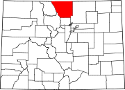
. The Fort Collins-Loveland MSA is defined as Larimer County, Colorado
Larimer County, Colorado
Larimer County is the seventh most populous and the ninth most extensive of the 64 counties of the State of Colorado of the United States. The county is located at the northern end of the Front Range, at the edge of the Colorado Eastern Plains along the border with Wyoming...
. The Census Bureau estimates that the population was 298,382 in 2009, an 18.64% increase since 2000. Fort Collins-Loveland MSA is the 156th most populous
Table of United States Metropolitan Statistical Areas
thumb|An enlargeable map of the 942 [[Core Based Statistical Area]]s of the [[United States]]. The 367 [[Metropolitan Statistical Area]]s are shown in red....
MSA in the United States
United States
The United States of America is a federal constitutional republic comprising fifty states and a federal district...
.
The Fort Collins-Loveland MSA includes the portion of Berthoud
Berthoud, Colorado
Berthoud is a Statutory Town in Larimer and Weld counties in the U.S. state of Colorado. Berthoud is situated north of the Little Thompson River, approximately halfway between the cities of Fort Collins, Colorado and Denver, Colorado along the Front Range Urban Corridor...
in Larimer County
Larimer County, Colorado
Larimer County is the seventh most populous and the ninth most extensive of the 64 counties of the State of Colorado of the United States. The county is located at the northern end of the Front Range, at the edge of the Colorado Eastern Plains along the border with Wyoming...
, Estes Park
Estes Park, Colorado
Estes Park is a town in Larimer County, Colorado, United States. A popular summer resort and the location of the headquarters for Rocky Mountain National Park, Estes Park lies along the Big Thompson River. Estes Park had a population of 5,858 at the 2010 census...
, Fort Collins
Fort Collins, Colorado
Fort Collins is a Home Rule Municipality situated on the Cache La Poudre River along the Colorado Front Range, and is the county seat and most populous city of Larimer County, Colorado, United States. Fort Collins is located north of the Colorado State Capitol in Denver. With a 2010 census...
, the portion of Johnstown
Johnstown, Colorado
Johnstown is a Home Rule Municipality in Larimer and Weld counties in the U.S. state of Colorado. The population was 3,827 at the 2000 census. As of 2010 the US Census Bureau estimates the population of Johnstown at 9,887.-Geography:...
in Larimer County
Larimer County, Colorado
Larimer County is the seventh most populous and the ninth most extensive of the 64 counties of the State of Colorado of the United States. The county is located at the northern end of the Front Range, at the edge of the Colorado Eastern Plains along the border with Wyoming...
, Loveland
Loveland, Colorado
Loveland is a Home Rule Municipality that is the second most populous city in Larimer County, Colorado, United States. Loveland is situated north of the Colorado State Capitol in Denver. Loveland is the 14th most populous city in Colorado. The United States Census Bureau that in 2010 the...
, Town of Timnath
Timnath, Colorado
The Town of Timnath is a Statutory Town located in Larimer County, Colorado, United States. Founded in 1882, Timnath is a small agricultural/farming community located southeast of Fort Collins, Colorado, approximately one-half mile east of the Harmony Road/Interstate 25 interchange, on a small...
, Wellington
Wellington, Colorado
Wellington is a Statutory Town in Larimer County, Colorado, United States. The population was 6,289 at the 2010 census.-Geography:Wellington is located at ....
, the portion of Windsor
Windsor, Colorado
The Town of Windsor is a Home Rule Municipality in Larimer and Weld counties in the U.S. state of Colorado. According to the 2010 Census, the population of the town was 18,644. Windsor is located in the region known as Northern Colorado. Windsor is situated north of the Colorado State Capitol in...
in Larimer County
Larimer County, Colorado
Larimer County is the seventh most populous and the ninth most extensive of the 64 counties of the State of Colorado of the United States. The county is located at the northern end of the Front Range, at the edge of the Colorado Eastern Plains along the border with Wyoming...
, and unincorporated
Unincorporated area
In law, an unincorporated area is a region of land that is not a part of any municipality.To "incorporate" in this context means to form a municipal corporation, a city, town, or village with its own government. An unincorporated community is usually not subject to or taxed by a municipal government...
areas of Larimer County
Larimer County, Colorado
Larimer County is the seventh most populous and the ninth most extensive of the 64 counties of the State of Colorado of the United States. The county is located at the northern end of the Front Range, at the edge of the Colorado Eastern Plains along the border with Wyoming...
, Colorado
Colorado
Colorado is a U.S. state that encompasses much of the Rocky Mountains as well as the northeastern portion of the Colorado Plateau and the western edge of the Great Plains...
.
See also
- Colorado census statistical areas
- Colorado metropolitan areasColorado metropolitan areasThe metropolitan areas of the State of Colorado include the urban statistical areas defined by the United States Office of Management and Budget and regions of urban population defined by other organizations.-Census statistical areas:...
- Combined Statistical AreaCombined Statistical AreaThe United States Office of Management and Budget defines micropolitan and metropolitan statistical areas. Metropolitan and micropolitan statistical areas consist of one or more counties...
- Core Based Statistical AreaCore based statistical areaA Core Based Statistical Area is a U.S. geographic area defined by the Office of Management and Budget based around an urban center of at least 10,000 people and adjacent areas that are socioeconomically tied to the urban center by commuting. Areas defined on the basis of these standards applied...
- Metropolitan Statistical Area
- Micropolitan Statistical Area
- Table of United States Combined Statistical AreasTable of United States Combined Statistical Areasthumb|An enlargeable map of the 125 [[Combined Statistical Area]]s of the [[United States]]The United States Office of Management and Budget has defined 125 Combined Statistical Areas for the United States of America...
- Table of United States Metropolitan Statistical AreasTable of United States Metropolitan Statistical Areasthumb|An enlargeable map of the 942 [[Core Based Statistical Area]]s of the [[United States]]. The 367 [[Metropolitan Statistical Area]]s are shown in red....
- Table of United States Micropolitan Statistical AreasTable of United States Micropolitan Statistical Areasthumb|An enlargeable map of the 942 [[Core Based Statistical Area]]s of the [[United States]]. The 576 [[Micropolitan Statistical Area]]s are shown in blue....
- Table of United States primary census statistical areas
- Larger urban regions that contain the Fort Collins-Loveland Metropolitan Statistical Area:
- Front Range Urban CorridorFront Range Urban CorridorThe Front Range Urban Corridor is an oblong region of urban population located along the eastern face of the Southern Rocky Mountains in the U.S. states of Colorado and Wyoming. The corridor derives its name from the Front Range, the mountain range that defines the west central boundary of the...
- North Central Colorado Urban AreaNorth Central Colorado Urban Areathumb|240px|An enlargeable map of the 13-county North Central Colorado Urban AreaThe North Central Colorado Urban Area comprises the four contiguous metropolitan statistical areas in the north central region of the State of Colorado: the Denver-Aurora Metropolitan Statistical Area, the Boulder...
- Front Range Urban Corridor
- Census statistical areas adjacent to Fort Collins-Loveland Metropolitan Statistical Area:
- Boulder Metropolitan Statistical Area
- Cheyenne metropolitan areaCheyenne metropolitan areaThe Cheyenne Metropolitan Statistical Area is a United States Census Bureau defined Metropolitan Statistical Area located in the Cheyenne region of the State of Wyoming. The Cheyenne Metropolitan Statistical Area is defined as Laramie County, Wyoming. Many consider the Cheyenne Metro Area to be...
- Denver-Aurora-Boulder Combined Statistical AreaDenver-Aurora-Boulder Combined Statistical Areathumb|300px|Map of the 12-county Denver-Aurora-Boulder Combined Statistical AreaThe Denver-Aurora-Boulder, CO Combined Statistical Area is a United States Census Bureau defined Combined Statistical Area located in the Denver region of the state of Colorado...
- Greeley Metropolitan Statistical Area
- Laramie Micropolitan Statistical Area