

Thüster Berg
Encyclopedia
Lower Saxon Hills
The Lower Saxon Hills are one the 73 natural regions in Germany defined by the Federal Agency for Nature Conservation . Geographically it covers roughly the same area as the Weser Uplands in its wider sense....
in central Germany
Germany
Germany , officially the Federal Republic of Germany , is a federal parliamentary republic in Europe. The country consists of 16 states while the capital and largest city is Berlin. Germany covers an area of 357,021 km2 and has a largely temperate seasonal climate...
. It is situated in the districts of Hameln-Pyrmont and Hildesheim in the federal state of Lower Saxony
Lower Saxony
Lower Saxony is a German state situated in north-western Germany and is second in area and fourth in population among the sixteen states of Germany...
.
Location
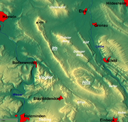
The Thüster Berg lies within a triangle formed by the villages of EimeEime
Eime is a town in the district of Hildesheim in Lower Saxony, Germany.-External links:*...
, Duingen
Duingen
Duingen is a village and a municipality in the district of Hildesheim, in Lower Saxony, Germany. It is situated approx. 25 km southwest of Hildesheim, and 40 km south of Hanover....
and Salzhemmendorf
Salzhemmendorf
Salzhemmendorf is a village and a municipality in the Hamelin-Pyrmont district, in Lower Saxony, Germany. It is situated approx. 20 km east of Hamelin and 31 km west of Hildesheim and is located on the route 1...
in the western half of the Leine Uplands
Leine Uplands
The Leine Uplands is a region in Germany's Central Uplands which forms a part of the Lower Saxon Hills and lies along the River Leine between Göttingen and Hanover...
, which itself is in the northern part of the Lower Saxon Hills
Lower Saxon Hills
The Lower Saxon Hills are one the 73 natural regions in Germany defined by the Federal Agency for Nature Conservation . Geographically it covers roughly the same area as the Weser Uplands in its wider sense....
. It is about 7 kilometres (4.3 mi) long and its highest peak is the Kanstein. It lies between Hemmendorf and Oldendorf in the north, Ahrenfeld, Deilmissen and Deinsen in the south, Marienhagen
Marienhagen
Marienhagen is a town in the district of Hildesheim in Lower Saxony, Germany....
in the southeast, Weenzen
Weenzen
Weenzen is a town in the district of Hildesheim in Lower Saxony, Germany....
and Thüste in the south, Levedagsen and the Domäne Eggersen in the west and the village of Salzhemmendorf to the northwest.
North of the Thüster Berg is the Osterwald, to the east the Külf
Külf
The Külf is a ridge, up to , in the Leine Uplands in the district of Hildesheim in the German state of Lower Saxony.- Location :With seven main summits, the Külf stretches for about 9 kilometres, lying in a triangle formed by the settlements of Gronau, Alfeld and Duingen...
, to the southeast the Duinger Berg
Duinger Berg
The Duinger Berg is a hill range, up to , in the Lower Saxon Hills and the district of Landkreis in the German state of Lower Saxony.- Location :...
and to the west the Ith
Ith
The Ith is a ridge in Germany's Central Uplands which is up to high. It lies about 40 km southwest of Hanover and, at 22 kilometres, is the longest line of crags in North Germany.- Geography :- Location :...
. The River Saale
Saale (Leine)
Saale is a river of Lower Saxony, Germany....
, a southwestern tributary
Tributary
A tributary or affluent is a stream or river that flows into a main stem river or a lake. A tributary does not flow directly into a sea or ocean...
of the Leine flows to the west and north of the ridge. Its northwestern part belongs to the Weser Uplands Schaumburg-Hamelin Nature Park.
The B 1
Bundesstraße 1
The Bundesstraße 1 or B1 is a German federal highway running in an east-west direction from the Dutch border near Aachen to the Polish border at Küstrin-Kietz on the Oder River.-Route description:...
federal highway runs past the Thüster Berg to the north and the B 240 to the southeast.
Geology and landscape
The Thüster Berg is an upfold of Thüster limestone. On its steeply sloping northern flanks there are several limestoneLimestone
Limestone is a sedimentary rock composed largely of the minerals calcite and aragonite, which are different crystal forms of calcium carbonate . Many limestones are composed from skeletal fragments of marine organisms such as coral or foraminifera....
crags, mostly hidden in forest, which have names such as Eckturm, Dreckturm, Falkenturm and Liebesnadel (literally: "Corner Tower", "Mud Tower", "Falcon Tower" and "Needle of Love"). The rock ledge of the Eckturm juts out of the forest towards the northwest below the summit of the Kanstein and forms a natural observation platform. There are disused limestone quarries
Quarries
Quarries - The "Royal Quarries" — not found in Scripture — is the namegiven to the vast caverns stretching far underneath the northern hill, Bezetha, on which Jerusalem is built. Out of these mammoth caverns stones, a hard limestone, have been quarried in ancient times for the buildings in the...
on the southwestern side of the ridge.
The Thüster Berg is densely wooded, especially with stands of deciduous trees. Amongst the species of tree that thrive here are birch
Birch
Birch is a tree or shrub of the genus Betula , in the family Betulaceae, closely related to the beech/oak family, Fagaceae. The Betula genus contains 30–60 known taxa...
and pine
Pine
Pines are trees in the genus Pinus ,in the family Pinaceae. They make up the monotypic subfamily Pinoideae. There are about 115 species of pine, although different authorities accept between 105 and 125 species.-Etymology:...
.