
Thiruvattar
Encyclopedia
Thiruvattaru is a panchayat town in Kanniyakumari district in the India
n state
of Tamil Nadu
.
and 30 km north-west of Nagercoil
. The two main rivers Pahrali River and Kothai
surround the village and join in Moovattumugam
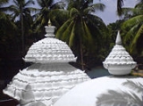
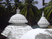
, giving the name Thiru (sacred)+ vatta (surround)+ aru (river). This village, where the Sri Adikesavaperumal Temple
is located, is one of the 108 Divya Desams
.
The Mathur hanging trough is located 5 km from Thiruvattar. The 100 years old St.James church,Puthenkadai is located 0.5 km from Thiruvattar. Thirparappu
waterfalls is located about 10 km from Thiruvattar.
 India census
, Thiruvattaru had a population of 18,404. Males constitute 49% of the population and females 51%. Thiruvattaru has an average literacy rate of 77%, higher than the national average of 59.5%: male literacy is 78%, and female literacy is 75%. In Thiruvattaru, 10% of the population is under 6 years of age.
.
As per the latest restructuring, the Thiruvattar assembly constituency has been split and merged with nearby constituencies.
India
India , officially the Republic of India , is a country in South Asia. It is the seventh-largest country by geographical area, the second-most populous country with over 1.2 billion people, and the most populous democracy in the world...
n state
States and territories of India
India is a federal union of states comprising twenty-eight states and seven union territories. The states and territories are further subdivided into districts and so on.-List of states and territories:...
of Tamil Nadu
Tamil Nadu
Tamil Nadu is one of the 28 states of India. Its capital and largest city is Chennai. Tamil Nadu lies in the southernmost part of the Indian Peninsula and is bordered by the union territory of Pondicherry, and the states of Kerala, Karnataka, and Andhra Pradesh...
.
About the town
This town is situated 6 km north-east of MarthandamMarthandam
Martandam is a major trade centre in Kuzhithurai municipality across National Highway in the Kanyakumari district of Tamil Nadu, India, at the border with Kerala. Originally called Thoduvetty, it was a portion of Kanyakumari district which was added to the state of Tamil Nadu on November 1, 1956...
and 30 km north-west of Nagercoil
Nagercoil
Nagercoil is the 12th largest city in the southernmost Indian state of Tamil Nadu and a municipality and administrative headquarters of Kanyakumari District...
. The two main rivers Pahrali River and Kothai
Kothai
Kothai is a river in the district of Kanyakumari which originates from the Kodayar Lake. Kothai is name of a female in Tamil. In Tamil it means " Beautiful girl of no mistakes"...
surround the village and join in Moovattumugam
Moovattumugam
Moovattumugam is a hamlet situated 2 km north-west to Thiruvattar. Here both the rivers Kothai and Pahrali get unified to flow southwest towards the Arabian Sea....
, giving the name Thiru (sacred)+ vatta (surround)+ aru (river). This village, where the Sri Adikesavaperumal Temple
Sri Adikesavaperumal Temple
The Sri Adikesavaperumal Temple is a Hindu temple located in Thiruvattar, India and is one of the 108 Divya desams, the holy sites of Hindu Vaishnavism...
is located, is one of the 108 Divya Desams
Divya Desams
Divya Desams refer to 108 Vishnu temples that are mentioned in the works of the Tamil Azhvars . 105 of these are located in India, 1 in Nepal, while 2 are located outside of the Earthly realms. 'Divya' in Tamil language indicates premium and 'Desam' indicates place or temple.The two major deities...
.
The Mathur hanging trough is located 5 km from Thiruvattar. The 100 years old St.James church,Puthenkadai is located 0.5 km from Thiruvattar. Thirparappu
Thirparappu
Thirparappu falls is a natural beauty spot that attracts many tourists coming to Kanyakumari District.Thirparappu Falls is located 42 km from Nagercoil and a distance of 5 km from kulasekaram , and this famous falls in the Kodayar...
waterfalls is located about 10 km from Thiruvattar.
Demographics
Census
A census is the procedure of systematically acquiring and recording information about the members of a given population. It is a regularly occurring and official count of a particular population. The term is used mostly in connection with national population and housing censuses; other common...
, Thiruvattaru had a population of 18,404. Males constitute 49% of the population and females 51%. Thiruvattaru has an average literacy rate of 77%, higher than the national average of 59.5%: male literacy is 78%, and female literacy is 75%. In Thiruvattaru, 10% of the population is under 6 years of age.
Politics
Thiruvattar assembly constituency is part of Nagercoil (Lok Sabha constituency)Nagercoil (Lok Sabha constituency)
Nagercoil was a Lok Sabha constituency in Tamil Nadu, India. K. Kamaraj Nadar, the first elected Chief Minister of Tamil Nadu was elected twice to the Lok Sabha from here.- Kamarajar by-election victory :...
.
As per the latest restructuring, the Thiruvattar assembly constituency has been split and merged with nearby constituencies.