
.gif)
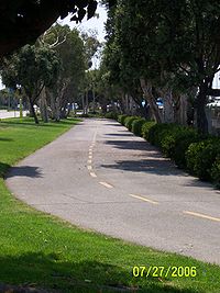
The Strand (bicycle path)
Encyclopedia
Pacific Ocean
The Pacific Ocean is the largest of the Earth's oceanic divisions. It extends from the Arctic in the north to the Southern Ocean in the south, bounded by Asia and Australia in the west, and the Americas in the east.At 165.2 million square kilometres in area, this largest division of the World...
shoreline in Los Angeles County, California
California
California is a state located on the West Coast of the United States. It is by far the most populous U.S. state, and the third-largest by land area...
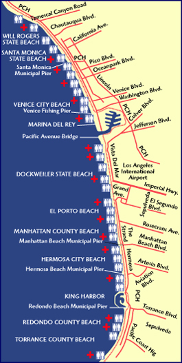
. The northern terminus of the trail is a paved Class 1 bicycle path at Will Rogers State Beach
Will Rogers State Beach
Will Rogers State Beach is a beach park on the Santa Monica Bay, at the Pacific coast of Southern California. It is located in Pacific Palisades and Santa Monica, Los Angeles County, California, and is protected as part of the California Department of Parks and Recreation...
in Pacific Palisades, Los Angeles. The southern terminus of the trail is in Torrance County Beach in Torrance
Torrance, California
Torrance is a city incorporated in 1921 and located in the South Bay region of Los Angeles County, California, United States. Torrance has of shore-front beaches on the Pacific Ocean, quieter and less well-known by tourists than others on the Santa Monica Bay, such as those of neighboring...
. The path is 22 miles long, and the midpoint between the two ends of the path is near the southern end of the Playa del Rey residential area.
People may confuse The Strand with a "boardwalk." The Strand is not considered a "boardwalk," because it is not made out of wood boards.
Route
The path begins in Will Rogers State Beach in the Pacific Palisades area of the city of Los Angeles. It continues southbound along the beach and passes through Santa Monica State BeachSanta Monica State Beach
Santa Monica State Beach is a California State Park operated by the city of Santa Monica.-Santa Monica Beach:The beach is located along Pacific Coast Highway in Santa Monica...
in the city of Santa Monica
Santa Monica, California
Santa Monica is a beachfront city in western Los Angeles County, California, US. Situated on Santa Monica Bay, it is surrounded on three sides by the city of Los Angeles — Pacific Palisades on the northwest, Brentwood on the north, West Los Angeles on the northeast, Mar Vista on the east, and...
, where the path passes underneath the Santa Monica Pier
Santa Monica Pier
The Santa Monica Pier is a large double-jointed pier located at the foot of Colorado Avenue in Santa Monica, California and is a prominent, 100-year-old landmark.-Pacific Park:...
. The Santa Monica portion of the path is an 8.5 miles (13.7 km) Class 1 path in Los Angeles County running from Temescal Canyon
Temescal Canyon, Los Angeles County
Temescal Canyon is a valley lying in the Los Angeles County portion of the Santa Monica Mountains in California....
in the north to Washington Boulevard in Venice
Venice, Los Angeles, California
Venice is a beachfront district on the Westside of Los Angeles, California, United States. It is known for its canals, beaches and circus-like Ocean Front Walk, a two-and-a-half mile pedestrian-only promenade that features performers, fortune-tellers, artists, and vendors...
in the south.
Realizing the success of paved pike paths in Europe, in the last decade of the nineteenth century, L.A. city planners proposed a bike path from Los Angeles to Santa Monica. The cost for the path was estimated at $200 per mile, with agreements from local farmers to allow the path to run across their lands.
The current path was proposed in the late 1960s and received final approval in 1988. The entire path is along the beach and was adamantly opposed by beachfront homeowners, who managed for two decades to stop the path from reaching Santa Monica. The last section of the path was opened in 1989.
The path then passes through Venice City Beach in Venice. The Class 1 bicycle path ends at the Venice Fishing Pier and riders must continue on the Class 2 bicycle path along Washington Boulevard
Washington Boulevard (Los Angeles)
Washington Boulevard is the longest continuous east-west arterial road in Los Angeles, California. It starts by the Pacific Ocean just west of Pacific Avenue in Marina del Rey, and ends far to the east in the city of Whittier, on Whittier Boulevard. It is south of Venice Boulevard for most of its...
. The Class 2 path eventually veers off of Washington Boulevard and takes riders around Marina Del Rey until it reaches a Class 1 path running alongside the main channel of the marina, an extension of the Ballona Creek bicycle path
Ballona Creek bicycle path
The Ballona Creek bicycle path is a six-mile stretch of Class 1 bicycle path in Los Angeles that parallels Ballona Creek for its entire length. It starts where Jefferson Boulevard veers south to spawn National Boulevard in Culver City, passes through Del Rey and Playa Vista, and ending joining The...
.
Dockweiler State Beach
Dockweiler State Beach is a Los Angeles beach protected under the state park system. Part of the park is located directly under the flight path of the immediately adjacent Los Angeles International Airport. Additionally, it is one of the few beaches in Los Angeles County where bonfires are permitted...
(which abuts Los Angeles International Airport
Los Angeles International Airport
Los Angeles International Airport is the primary airport serving the Greater Los Angeles Area, the second-most populated metropolitan area in the United States. It is most often referred to by its IATA airport code LAX, with the letters pronounced individually...
and the city of El Segundo
El Segundo, California
El Segundo is a city in Los Angeles County, California, United States. Located on the Santa Monica Bay, it was incorporated on January 18, 1917, and is one of the Beach Cities of Los Angeles County and part of the South Bay Cities Council of Governments...
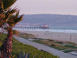
), El Porto Beach and Manhattan County Beach (both part of the city of Manhattan Beach
Manhattan Beach, California
Manhattan Beach is the wealthiest beachfront city located in southwestern Los Angeles County, California, USA. The city is on the Pacific coast, south of El Segundo, and north of Hermosa Beach. Manhattan Beach is the home of both beach and indoor volleyball, and surfing. During the winter, the...
).
Hermosa Beach, California
Hermosa Beach is a beachfront city in Los Angeles County, California, United States. Its population was 19,506 at the 2010 census, up from 18,566 at the 2000 census....
, riders have the choice of either continuing along the Class 1 bicycle path that runs alongside Hermosa City Beach or riding on a Class 2 bicycle lane that runs parallel to Hermosa Avenue.
The path continues along the beach through Redondo County Beach in the city of Redondo Beach. The path passes through the parking structure of the Redondo Beach pier
Redondo Beach pier
The Redondo Beach pier is located in Redondo Beach, California and stretches out onto the Pacific Ocean. The pier has been rebuilt and altered by storms and redevelopments. Its official name is "Municipal Pier", and it has also been called the "Endless Pier"...
. Signs instruct riders to dismount and walk their bikes across the main entrance to the pier and the King Harbor marina.
The path ends in Torrance County Beach, in a parking lot at the base of the Palos Verdes Peninsula hills.
See also
- Los Angeles bike paths
- Marvin BraudeMarvin BraudeMarvin Braude was a member of the Los Angeles City Council for 32 years, between 1965 and 1997—the third-longest-serving council member in the history of the city...
(1920–2005) Los Angeles City Council member (1965–97), worked for bicycle paths