
The Lands of Lochridge
Encyclopedia
Cunninghame
Cunninghame is a former comital district of Scotland and also a district of the Strathclyde Region from 1975–1996.-Historic Cunninghame:The historic district of Cunninghame was bordered by the districts of Renfrew and Clydesdale to the north and east respectively, by the district of Kyle to the...
, near Stewarton
Stewarton
Stewarton is a town in East Ayrshire, Scotland. In comparison to the neighbouring towns of Kilmaurs, Fenwick, Dunlop and Lugton, it is a relatively large town, with a population of over 6,500. It is 300 feet above sea level.Groome, Francis H. . Ordnance Gazetteer of Scotland. Pub. Caxton. London....
in what is now East Ayrshire
East Ayrshire
East Ayrshire is one of 32 council areas of Scotland. It borders on to North Ayrshire, East Renfrewshire, South Lanarkshire, South Ayrshire and Dumfries and Galloway...
, Scotland
Scotland
Scotland is a country that is part of the United Kingdom. Occupying the northern third of the island of Great Britain, it shares a border with England to the south and is bounded by the North Sea to the east, the Atlantic Ocean to the north and west, and the North Channel and Irish Sea to the...
.
The history of Lochridge
Nether Lochridge or Lochrig as it was originally known, belonged to the Arnots for nearly 400 years. Mathew Arnot Stewart, the last direct representative of the family, sold the estate to David Provan, a surgeon, in 1830. Robertson (1820) shows an Upper Lochridge as well as Lochridge. This property seems to be at the site of what is now called Draffen House. Colonel Barns owned Upper Lochrig, part of Auchenharvie and Kirkland in 1820. A Hugh Wyllie who died on 22 December 1823, aged 51, is recorded on his tombstone in the Laigh Kirk churchyard in StewartonStewarton
Stewarton is a town in East Ayrshire, Scotland. In comparison to the neighbouring towns of Kilmaurs, Fenwick, Dunlop and Lugton, it is a relatively large town, with a population of over 6,500. It is 300 feet above sea level.Groome, Francis H. . Ordnance Gazetteer of Scotland. Pub. Caxton. London....
as having lived at Over Lochridge.
In 1691 the Hearth Tax records show that the mansion house had seven hearths and that seven other dwellings were associated with the estate.
Mr. J. Proven of Lochridge attended the famous 1839 Eglinton Tournament in what is now Eglinton Country Park
Eglinton Country Park
Eglinton Country Park is located in the grounds of the old Eglinton Castle estate, Kilwinning, North Ayrshire, Scotland . Eglinton Park is situated in the parish of Kilwinning, part of the former district of Cunninghame, and covers an area of 400 hectares...
and he was alloted a seat in the Grand Stand.
It is stated locally that a Lochridge Halt existed on the railway at one time, but no evidence has yet been found to support this. The new junction on the doubled track from Stewarton to Lugton is officially known as 'Lochridge Junction'.
Wardhead Park
Wardhead, next to Lochridge, was farmed by Alexander Cameron and his spouse Janet Ingrwm in the early 18th. century. Alexander died on 5 April 1761 and Janet died on 20 May 1736, aged 50. They were both buried at the Laigh Kirk in Stewarton.
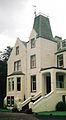
This was a dower house or factor's residence on the Lochridge Estate and was built around 1860. The older farmhouse building may be incorporated at the back. An old walled garden was later used as a car park.
Cunninghame
Cunninghame is a former comital district of Scotland and also a district of the Strathclyde Region from 1975–1996.-Historic Cunninghame:The historic district of Cunninghame was bordered by the districts of Renfrew and Clydesdale to the north and east respectively, by the district of Kyle to the...
, near Stewarton
Stewarton
Stewarton is a town in East Ayrshire, Scotland. In comparison to the neighbouring towns of Kilmaurs, Fenwick, Dunlop and Lugton, it is a relatively large town, with a population of over 6,500. It is 300 feet above sea level.Groome, Francis H. . Ordnance Gazetteer of Scotland. Pub. Caxton. London....
in what is now East Ayrshire
East Ayrshire
East Ayrshire is one of 32 council areas of Scotland. It borders on to North Ayrshire, East Renfrewshire, South Lanarkshire, South Ayrshire and Dumfries and Galloway...
, Scotland
Scotland
Scotland is a country that is part of the United Kingdom. Occupying the northern third of the island of Great Britain, it shares a border with England to the south and is bounded by the North Sea to the east, the Atlantic Ocean to the north and west, and the North Channel and Irish Sea to the...
.
The history of Lochridge
Nether Lochridge or Lochrig as it was originally known, belonged to the Arnots for nearly 400 years. Mathew Arnot Stewart, the last direct representative of the family, sold the estate to David Provan, a surgeon, in 1830.Dobie, Page 319 Robertson (1820) shows an Upper Lochridge as well as Lochridge. This property seems to be at the site of what is now called Draffen House. Colonel Barns owned Upper Lochrig, part of Auchenharvie and Kirkland in 1820. A Hugh Wyllie who died on 22 December 1823, aged 51, is recorded on his tombstone in the Laigh Kirk churchyard in StewartonStewarton
Stewarton is a town in East Ayrshire, Scotland. In comparison to the neighbouring towns of Kilmaurs, Fenwick, Dunlop and Lugton, it is a relatively large town, with a population of over 6,500. It is 300 feet above sea level.Groome, Francis H. . Ordnance Gazetteer of Scotland. Pub. Caxton. London....
as having lived at Over Lochridge.
In 1691 the Hearth Tax records show that the mansion house had seven hearths and that seven other dwellings were associated with the estate.Urquhart, Page 105
Mr. J. Proven of Lochridge attended the famous 1839 Eglinton Tournament in what is now Eglinton Country Park
Eglinton Country Park
Eglinton Country Park is located in the grounds of the old Eglinton Castle estate, Kilwinning, North Ayrshire, Scotland . Eglinton Park is situated in the parish of Kilwinning, part of the former district of Cunninghame, and covers an area of 400 hectares...
and he was alloted a seat in the Grand Stand.
It is stated locally that a Lochridge Halt existed on the railway at one time, but no evidence has yet been found to support this. The new junction on the doubled track from Stewarton to Lugton is officially known as 'Lochridge Junction'.
Wardhead Park
Wardhead, next to Lochridge, was farmed by Alexander Cameron and his spouse Janet Ingrwm in the early 18th. century. Alexander died on 5 April 1761 and Janet died on 20 May 1736, aged 50. They were both buried at the Laigh Kirk in Stewarton.
This was a dower house or factor's residence on the Lochridge Estate and was built around 1860. The older farmhouse building may be incorporated at the back. An old walled garden was later used as a car park.Davis, page 397 It is now the site of Provan Engineering that manufactures wind turbines.
The Micro history of Lochridge
The term 'Lochridge' or 'Lockridge' is used as a rare surname, appearing 319 in 88.7 million of the 1997 US population.American family names. Accessed : 2009/11/28The estate stands on a pronounced ridge and the 'Loch' may refer to Lambroughton Loch
Lambroughton Loch
Lambroughton Loch or Wheatrig Loch was situated in a low lying area between the farms and dwellings of Hillhead, Lambroughton, Wheatrig, Titwood and Lochridge mainly in the Parish of Dreghorn, North Ayrshire...
which may have reached this site.
Robert Burnes, the poet's uncle, lived at Titwood near Kilmaurs
Lambroughton
Lambroughton is a village in the old Barony of Kilmaurs, North Ayrshire, Scotland. This is a rural area famous for its milk and cheese production and the Ayrshire or Dunlop breed of cattle.-Origins of the name:...
for several years and worked in the lime quarries at Lochridge until he was crippled with arthritis or rheumatism and moved to Stewarton.Boyle, Page 154
In 1820 only six people were qualified to vote as freeholders in Stewarton Parish, being proprietors of Lochridge (Stewart), Robertland (Hunter Blair), Kirkhill (Col.J.S.Barns), Kennox (McAlester), Lainshaw (Cunninghame), and Corsehill (Montgomery Cunninghame). Dunlop had only two people qualified to vote by right as freeholders.
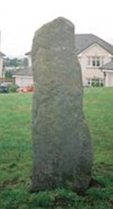
The Draffen Stone used to be located in a field near the house of the same name. Due to a housing development it has been moved to a site in front of Draffen House. It is not known whether this stone is merely a 'rubbing stone' for cattle or a menhir
Menhir
A menhir is a large upright standing stone. Menhirs may be found singly as monoliths, or as part of a group of similar stones. Their size can vary considerably; but their shape is generally uneven and squared, often tapering towards the top...
. It is not recorded by Historic Scotland
Historic Scotland
Historic Scotland is an executive agency of the Scottish Government, responsible for historic monuments in Scotland.-Role:As its website states:...
.
The Stewarton Cricket Club had its grounds located between Lochridge and Ward Park.
The road from Stewarton to Kilmaurs did not run via Lochridge until the 18th century when the Toll Road was built. The old driveway from Lochridge to Stewarton came out near Peter's Brae planting; the original entrance is still present today (2008). The course of the drive was altered when the railway was built in the 1840.
In February 2009 the Lochrig or Lochridge Burn was severely polluted with diesel oil spilled from a train derailed at the railway bridge near Peacockbank farm. Mitigation measures were put in place, however pollution eventually reached the River Irvine
River Irvine
The River Irvine is a river flowing through southwest Scotland, with its watershed on the Lanarkshire border of Ayrshire at an altitude of above sea-level, near Drumclog, and SW by W of Strathaven...
.METRO, Page 5.
See also
- Barony of PeacockbankBarony of PeacockbankThe Barony of Peacockbank was in the old feudal Baillerie of Cunninghame, near Stewarton in what is now East Ayrshire, Scotland.-The history of Peacockbank:...
- ChapeltounChapeltounChapeltoun is an estate on the banks of the Annick Water in East Ayrshire, Scotland. This is a rural area famous for its milk and cheese production and the Ayrshire or Dunlop breed of cattle.-Templeton and the Knights Templar:...
- LambroughtonLambroughtonLambroughton is a village in the old Barony of Kilmaurs, North Ayrshire, Scotland. This is a rural area famous for its milk and cheese production and the Ayrshire or Dunlop breed of cattle.-Origins of the name:...
- Corsehill
- A Researcher's Guide to Local History terminology
Sources
- Boyle, Andrew M. (1996), The Ayrshire book of Burns-lore. Darvel : Alloway Publishing. ISBN 0-907526-71-3.
- Davis, Michael C. (1991). The Castles and Mansions of Ayrshire. Ardrishaig : Spindrift Press
- Dobie, James D. (ed Dobie, J.S.) (1876). Cunninghame, Topographized by Timothy Pont 1604–1608, with continuations and illustrative notices. Pub. John Tweed, Glasgow.
- METRO. January 28, 2009.
- Urquhart, Robert H. et al. (1998). The Hearth Tax for Ayrshire 1691. Ayrshire Records Series V.1. Ayr : Ayr Fed Hist Soc ISBN 0-9532055-0-9.
External links
- http://geo.nls.uk/roy/ General Roy's Military map of Scotland.
- http://www.futuremuseum.co.uk Details of the De Soulis, De Morville and other Cunninghame families.