

Thandiani
Encyclopedia
Galyat
Galyat region is an area roughly 50–80 km north-east of Islamabad, Pakistan, on both sides of the Khyber Pakhtunkhwa-Punjab border.The word Galyat is the plural of the Urdu word gali, which means an alley between two mountains on both sides of which there are valleys and it is not the highest...
area of Pakistan
Pakistan
Pakistan , officially the Islamic Republic of Pakistan is a sovereign state in South Asia. It has a coastline along the Arabian Sea and the Gulf of Oman in the south and is bordered by Afghanistan and Iran in the west, India in the east and China in the far northeast. In the north, Tajikistan...
.
History
Thandiani was established as a SanatoriumSanatorium
A sanatorium is a medical facility for long-term illness, most typically associated with treatment of tuberculosis before antibiotics...
during British rule
British Raj
British Raj was the British rule in the Indian subcontinent between 1858 and 1947; The term can also refer to the period of dominion...
, for the convenience of officers stationed at the neighbouring cantonment of Abbottabad
Abbottabad
Abbottabad is a city located in the Hazara region of the Khyber Pakhtunkhwa province, in Pakistan. The city is situated in the Orash Valley, northeast of the capital Islamabad and east of Peshawar at an altitude of and is the capital of the Abbottabad District...
, it contained some European houses and a small bazaar, which were occupied only during the summer months
Most of local population belongs to the Sarrara
Sarrara
The Sarrara are a tribe found in the Hazara Division of Khyber-Pakhtunkhwa province of Pakistan.-History and origin:They connect themselves with the Dhund Abbasi and the Tanoli tribes, which also found in the Hazara Division. According to of their traditions,they say at some time they came from...
tribe.
Location
Thandiani is located in the south of Abbottabad DistrictAbbottabad District
Abbottabad is a district in the Khyber Pakhtunkhwa province of Pakistan. The district covers an area of 1,969 km with the city of Abbottabad being the principal town...
at 34°13'60N 73°22'0E and is about 31 kilometres from Abbottabad
Abbottabad
Abbottabad is a city located in the Hazara region of the Khyber Pakhtunkhwa province, in Pakistan. The city is situated in the Orash Valley, northeast of the capital Islamabad and east of Peshawar at an altitude of and is the capital of the Abbottabad District...
city at the foothills of the Himalayas
Himalayas
The Himalaya Range or Himalaya Mountains Sanskrit: Devanagari: हिमालय, literally "abode of snow"), usually called the Himalayas or Himalaya for short, is a mountain range in Asia, separating the Indian subcontinent from the Tibetan Plateau...
. To the east beyond the Kunhar River
Kunhar River
The Kunhar River also known as ' Persian: "eye's repose" is long river, located primarily in the Khyber Pakhtunkhwa province, northern Pakistan. It is in the Indus River watershed basin.-Route:...
lie the snow covered mountain ranges of Kashmir
Kashmir
Kashmir is the northwestern region of the Indian subcontinent. Until the mid-19th century, the term Kashmir geographically denoted only the valley between the Great Himalayas and the Pir Panjal mountain range...
. Visible to the north and northeast are the mountains of Kohistan
Kohistan
Kohistan, also transliterated Kuhistan, Kuhiston, Quhistan , may refer to:in Afghanistan*Kohistan, Kapisa Province, Kapisa Province, a town and administrative center of Hesa Awal Kohistan District...
and Kaghan
Kaghan
Kaghan is a small town and union council of the Balakot Tehsil, in Mansehra District of Khyber-Pakhtunkhwa province of Pakistan. It has a reputation as a place of great natural beauty....
. To the northwest are snowy ranges of Swat and Chitral
Chitral
Chitral or Chetrar , translated as field in the native language Khowar, is the capital of the Chitral District, situated on the western bank of the Kunar River , in Pakistan. The town is at the foot of Tirich Mir, the highest peak of the Hindu Kush, high...
. The hills of Thandiani are about 9,000 feet (2,750 m) above sea level. Most of the people of residing here belonge to(Qureshi), Gujjars, and Sardars (Karlals). The nearest villages are Inderseri, Chattri, and Sialkot.Mohallah jabbri of lal.Haweli
From.
Tourism
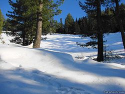
Main article: Hill stations in PakistanThandiani charactersize excellent weather and greenery in summer and snow land in winter.Many people from Khyber Pakhtunkhwa and all over Pakistan visit it especially in summer season.Being high altitude , its senery looks very attractive.
Wild life
The mountains around it are thickly forested. Local wildlife include leopards, monkeys, pheasants and the flying squirrel, to name a few.Earthquake 2005
The area and its surrounding villages were damaged by the 2005 Kashmir Earthquake2005 Kashmir earthquake
The 2005 Kashmir earthquake was a major earthquake centered in Pakistan-administered Kashmir known as Azad Kashmir, near the city of Muzaffarabad, affecting Gilgit-Baltistan and Khyber Pakhtunkhwa province of Pakistan. It occurred at 08:52:37 Pakistan Standard Time on 8 October 2005...
.