
Texas State Highway Loop 150
Encyclopedia
Loop 150 is a 2.41 miles (3.88 km) loop route
in the city of Bastrop
in the U.S. state
of Texas
. Loop 150 follows the route of old alignment of SH 71
through Bastrop
. The route of SH 71 changed when the state built a bypass around Bastrop. Loop 150 leaves SH 71 on the west side of town and rejoins SH 71 on the east side, crossing the Colorado River
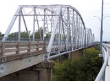
. The historic Colorado River Bridge at Bastrop is part of Loop 150.
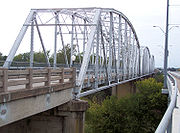 The routing of the roadway had been proposed as early as 1919 as SH 3A. In 1924, the historic Colorado River Bridge at Bastrop was completed to provide access to both sides of the Colorado River. By 1926, the designation had been changed to SH 71. In 1959, Loop 150 was designated to follow the old alignment of SH 71 in Bastrop following the completion of the new segment of SH 71 to the south. Loop 150 used the Colorado River Bridge at Bastrop until the completion of a new parallel bridge in 1993. The old bridge was closed to traffic and is still in use as a pedestrian bridge. The overpasses at the western terminus with SH 71 were completed over Loop 150 in 2005.
 Loop 150 begins on the west side of Bastrop at a diamond interchange
with SH 21 and SH 71. The loop heads northeast from the interchange to a crossing of the Colorado River
. After the river crossing, the road heads east along Chestnut Street through Bastrop. Loop 150 continues to the east through the city to an intersection with SH 21 and 95. SH 21 enters the intersection from the south concurrent with SH 95 and begins to run concurrently with Loop 150 as the two head to the east. As the loop begins to curve back towards the southeast, SH 21 leaves the concurrency to the northeast. Access to nearby Bastrop State Park
is provided by an intersection with Park Road 1 just east of the SH 21 intersection. Loop 150 continues to the southeast to its endpoint at a concurrent SH 71 and SH 95.
Loop route
A loop route is a highway or other major road that extends out from a typically longer, more important parents road to enter and circle a large city. A loop can function as a bypass for through traffic and also to service outlying suburbs....
in the city of Bastrop
Bastrop, Texas
-Demographics:As of the census of 2000, there are 5340 people in Bastrop, organized into 2034 households and 1336 families. The population density is 734.8 people per square mile . There are 2,239 housing units at an average density of 308.1 per square mile...
in the U.S. state
U.S. state
A U.S. state is any one of the 50 federated states of the United States of America that share sovereignty with the federal government. Because of this shared sovereignty, an American is a citizen both of the federal entity and of his or her state of domicile. Four states use the official title of...
of Texas
Texas
Texas is the second largest U.S. state by both area and population, and the largest state by area in the contiguous United States.The name, based on the Caddo word "Tejas" meaning "friends" or "allies", was applied by the Spanish to the Caddo themselves and to the region of their settlement in...
. Loop 150 follows the route of old alignment of SH 71
State Highway 71 (Texas)
State Highway 71 or SH 71 is a Texas state highway that runs . The northern terminus is at US 87 and US 377 south of Brady and its southern terminus is at SH 35 near Blessing. This highway is designated the "10th Mountain Division Highway" from SH 95 to Interstate 35.Through Austin, SH 71 is known...
through Bastrop
Bastrop, Texas
-Demographics:As of the census of 2000, there are 5340 people in Bastrop, organized into 2034 households and 1336 families. The population density is 734.8 people per square mile . There are 2,239 housing units at an average density of 308.1 per square mile...
. The route of SH 71 changed when the state built a bypass around Bastrop. Loop 150 leaves SH 71 on the west side of town and rejoins SH 71 on the east side, crossing the Colorado River
Colorado River (Texas)
The Colorado River is a river that runs through the U.S. state of Texas; it should not be confused with the much longer Colorado River which flows from Colorado into the Gulf of California....
. The historic Colorado River Bridge at Bastrop is part of Loop 150.
History
Route description
Diamond interchange
A diamond interchange is a common type of road junction, used where a freeway crosses a minor road. The freeway itself is grade-separated from the minor road, one crossing the other over a bridge...
with SH 21 and SH 71. The loop heads northeast from the interchange to a crossing of the Colorado River
Colorado River (Texas)
The Colorado River is a river that runs through the U.S. state of Texas; it should not be confused with the much longer Colorado River which flows from Colorado into the Gulf of California....
. After the river crossing, the road heads east along Chestnut Street through Bastrop. Loop 150 continues to the east through the city to an intersection with SH 21 and 95. SH 21 enters the intersection from the south concurrent with SH 95 and begins to run concurrently with Loop 150 as the two head to the east. As the loop begins to curve back towards the southeast, SH 21 leaves the concurrency to the northeast. Access to nearby Bastrop State Park
Bastrop State Park
Bastrop State Park is a state park in Bastrop County in central Texas. The park was established in 1938 and consists of stands of Loblolly Pines mixed with Post Oak and junipers.-History:...
is provided by an intersection with Park Road 1 just east of the SH 21 intersection. Loop 150 continues to the southeast to its endpoint at a concurrent SH 71 and SH 95.