

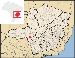
Tapira, Minas Gerais
Encyclopedia
Minas Gerais
Minas Gerais is one of the 26 states of Brazil, of which it is the second most populous, the third richest, and the fourth largest in area. Minas Gerais is the Brazilian state with the largest number of Presidents of Brazil, the current one, Dilma Rousseff, being one of them. The capital is the...
. Its population as of 2007 was 3,575 people living in a total area of 1,180 km². The city belongs to the meso-region of Triângulo Mineiro and Alto Paranaíba and to the micro-region of Araxá. It became a municipality in 1963.
Location
The city center of Tapira is located at an elevation of 907 meters, between the Ribeirão do Inferno and the Rio das Velhas valley. Neighboring municipalities are: AraxáAraxá
Araxá is a city and municipality in southwest Minas Gerais state, Brazil. The population was 87,764 inhabitants and the area of the municipality is 1,283 km², with 345 km² making up the urban perimeter.-Geography:...
(N), Ibiá
Ibiá
Ibiá is a Brazilian municipality located in the west of the state of Minas Gerais. Its population as of 2007 was estimated to be 22,069 people living in a total area of 2,707 km². The city belongs to the mesoregion of Triângulo Mineiro and Alto Paranaíba and to the micro-region of Araxá...
(NE), São Roque de Minas
São Roque de Minas
São Roque de Minas is a Brazilian municipality located in the west of the state of Minas Gerais. Its population as of 2007 was 6,141 people living in a total area of 2,100 km². The city belongs to the meso-region of Oeste de Minas and to the micro-region of Piumhi...
(S and SE), and Sacramento
Sacramento, Minas Gerais
Sacramento is a Brazilian municipality located in the west of the state of Minas Gerais. Its population as of 2007 was 22,159 people living in a total area of 3,071 km². The city belongs to the meso-region of Triângulo Mineiro and Alto Paranaíba and to the micro-region of Araxá...
(W).
Communications and Distances
Tapira is connected to AraxáAraxá
Araxá is a city and municipality in southwest Minas Gerais state, Brazil. The population was 87,764 inhabitants and the area of the municipality is 1,283 km², with 345 km² making up the urban perimeter.-Geography:...
by state highway MG-146 and national highway BR-452. The nearest railroad station is in Araxá
Araxá
Araxá is a city and municipality in southwest Minas Gerais state, Brazil. The population was 87,764 inhabitants and the area of the municipality is 1,283 km², with 345 km² making up the urban perimeter.-Geography:...
.
Other distances (in km.)
- Uberaba: 167
- Araxá: 60
- Belo Horizonte: 400
Economic activities
Mining of phosphate is the most important economic activity. The GDP in 2005 was approximately R$162 million, with 12 million reais from taxes, 28 million reais from services, 98 million reais from industry, and 23 million reais from agriculture. There were 272 rural producers on 163,000 hectares of land. 31 farms had tractors (2006). Approximately 800 persons were dependent on agriculture. The main crops are coffee, potatoes, rice, soybeans, beans, and corn. There were 36,000 head of cattle (2006), most of which were raised for milk and cheese production.There was 1 bank (2007) and 470 automobiles (2007), giving a ratio of 7 inhabitants per automobile.
Working population
- Workers in mining: 587
- Workers in construction: 586
- Workers in food and lodging: 442
Health and education
In the health sector there were 3 public health clinics (2005). Patients with more serious health conditions are transported to Araxá or to Uberaba, which are connected by good roads. Educational needs of 800 students were met by 3 primary schools, 1 middle school, and 1 pre-primary school.- Municipal Human Development IndexHuman Development IndexThe Human Development Index is a composite statistic used to rank countries by level of "human development" and separate "very high human development", "high human development", "medium human development", and "low human development" countries...
: 0.780 (2000) - State ranking: 113 out of 853 municipalities as of 2000
- National ranking: 1053 out of 5,138 municipalities as of 2000
- Literacy rate: 88%
- Life expectancy: 74 (average of males and females)
In 2000 the per capita monthly income of R$240.00 was below the state and national average of R$276.00 and R$297.00 respectively.
The highest ranking municipality in Minas Gerais in 2000 was Poços de Caldas
Poços de Caldas
Poços de Caldas is a city and municipality in south-western Minas Gerais state, Brazil, in the microregion of the same name. Its estimated population in 2009 was 151,449 inhabitants...
with 0.841, while the lowest was Setubinha
Setubinha
Setubinha is a municipality in the northeast of the Brazilian state of Minas Gerais. As of 2007 the population was 10,834 in a total area of 536 km². The elevation is 729 metres. It is part of the IBGE statistical microregion of Teófilo Otoni...
with 0.568. Nationally the highest was São Caetano do Sul
São Caetano do Sul
São Caetano do Sul is a city in São Paulo state in Brazil, located in the Greater São Paulo Metropolitan Area. It is the city with the highest per capita income in Brazil and it also has the highest Human Development Index .-Geography:São Caetano do Sul is located on a plateau that is part of the...
in São Paulo with 0.919, while the lowest was Setubinha. In more recent statistics (considering 5,507 municipalities) Manari in the state of Pernambuco
Pernambuco
Pernambuco is a state of Brazil, located in the Northeast region of the country. To the north are the states of Paraíba and Ceará, to the west is Piauí, to the south are Alagoas and Bahia, and to the east is the Atlantic Ocean. There are about of beaches, some of the most beautiful in the...
has the lowest rating in the country—0,467—putting it in last place.