
Tapere
Encyclopedia
A tapere or sub-district is a low level of traditional land subdivision on five of the Lower Cook Islands
(Rarotonga
, Mangaia
, Aitutaki
, Atiu
, and Mauke
), comparable to the ahupua'a
of the main Hawaiian Islands
. Among the populated raised islands, only Mitiaro
is not subdivided into tapere. The remaining southern Cook Islands, Manuae, Palmerston
and Takutea
are atoll
s and/or uninhabited, and therefore not subject to this type of traditional subdivision. The atolls of the northern Cook Islands are subdivided into motu (populated atoll islets), instead.
A tapere is a subdivision of a district (the major island subdivision) or puna, which is headed by a district chiefs or pava. A tapere is normally headed by a mataiapo
(a chief of a major lineage) or ariki
(a high chief, the titular head of a tribe). It is occupied by the matakeinanga, the local group composed of the residential core of a major lineage, plus affines and other permissive members.
Most of the tapere lands are subdivided among the minor lineages, each of which was headed by a rangatira
or komono, or by the mataiapo himself.
Some of the larger minor lineages were again subdivided into segments known as kiato, and the head of such a segment was also referred to as a kiato. While kiato were generally junior relatives of the rangatira or other chief to whom they were subordinate, immigrant groups were sometimes also taken in and given the status of kiato.
Below that level, there is the uanga, the extended family, the residential core of which occupied a household.
Historically, taperes were almost always wedge-shaped - the boundaries beginning at defined points on the outer reef and running inland to enclose an ever narrowing strip of land until converging at a point in or near the center of the island. By this type of delineation, any one tapere included every category of soil type and land surface of the island, from the typically mountainous interior, where forest products were colleted, through fertile valleys where the major food crops were grown, across the rocky coastal strip of elevated fossil coral (makatea), out to the lagoon and fringing reef.
Rarotonga has more tapere than any other island, 54 in number.
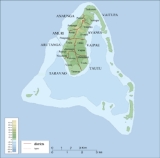
 Aitutaki
is subdivided into eight districts with 19 tapere according to the constitution. The 16 minor islands, 12 of the motu
, are outside of this subdivision scheme:
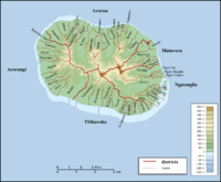
 In the case of Atiu
, the six villages correspond to the six tapere:
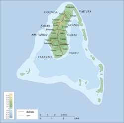
 Mangaia
is subdivided into six districts, which are further subdivided into 38 tapere.
In the Cook Islands Constitution however, the six districts are called tapere.
is subdivided into four districts. Vaimutu and Makatea are not further subdivided and correspond to one tapere each. Ngatiarua and Areora districts are subdivided into 6 and 3 tapere, respectively, totalling 11 tapere for the whole island:
 Rarotonga
is subdivided into five traditional puna districts (not to be confused with the three vaka districts that served as local government units with councils and mayors from 1997 to February 2008), with a total of 54 tapere, more than any other island of the Cooks Islands:
Cook Islands
The Cook Islands is a self-governing parliamentary democracy in the South Pacific Ocean in free association with New Zealand...
(Rarotonga
Rarotonga
Rarotonga is the most populous island of the Cook Islands, with a population of 14,153 , out of the country's total population of 19,569.The Cook Islands' Parliament buildings and international airport are on Rarotonga...
, Mangaia
Mangaia
Mangaia is the most southerly of the Cook Islands and the second largest, after Rarotonga.-Geography:...
, Aitutaki
Aitutaki
Aitutaki, also traditionally known as Araura, Ararau and Utataki, is one of the Cook Islands, north of Rarotonga. It has a population of approximately 2,000. Aitutaki is the second most visited island of the Cook Islands. The capital is Arutanga on the west side.-Geography:Aitutaki is an "almost...
, Atiu
Atiu
Atiu, also known as Enuamanu , is an island lying at 187 km to the northeast of Rarotonga, in the Southern Islands group of the Cook Islands Archipelago.-Geography:...
, and Mauke
Mauke
Mauke is a raised atoll island, the eastern most of the Cook Islands.-Geography:...
), comparable to the ahupua'a
Ahupua'a
In old Hawaii, ahupuaa was the common subdivision of the land. It is comparable to the tapere in the Southern Cook Islands. The traditional subdivision has four hierarchical levels:*mokupuni *moku...
of the main Hawaiian Islands
Hawaiian Islands
The Hawaiian Islands are an archipelago of eight major islands, several atolls, numerous smaller islets, and undersea seamounts in the North Pacific Ocean, extending some 1,500 miles from the island of Hawaii in the south to northernmost Kure Atoll...
. Among the populated raised islands, only Mitiaro
Mitiaro
Mitiaro, the fourth island in the Cook Islands group, is of volcanic origin. Standing in water 14,750 feet deep it is four miles across at its widest point.-Geography:...
is not subdivided into tapere. The remaining southern Cook Islands, Manuae, Palmerston
Palmerston Island
Palmerston Island is a coral atoll in the Cook Islands in the Pacific Ocean about 500 km northwest of Rarotonga. It was discovered by James Cook on 16 June 1774.-Overview:...
and Takutea
Takutea
Takutea, in the Cook Islands, is a small uninhabited island 21 km northwest of Atiu in the southern Cook Islands. Because it is only 1.22 km² in size and has a very dangerous landing at the northwest corner of the reef, it has been designated a wildlife sanctuary, mainly for the red-tailed tropic...
are atoll
Atoll
An atoll is a coral island that encircles a lagoon partially or completely.- Usage :The word atoll comes from the Dhivehi word atholhu OED...
s and/or uninhabited, and therefore not subject to this type of traditional subdivision. The atolls of the northern Cook Islands are subdivided into motu (populated atoll islets), instead.
A tapere is a subdivision of a district (the major island subdivision) or puna, which is headed by a district chiefs or pava. A tapere is normally headed by a mataiapo
Mataiapo
A mataiapo or mata'iapo is a hereditary chiefly title in the Cook Islands. The head of a sub-tribe, subject to the ariki as far as the whole tribe is concerned and owing him traditional allegiance, but otherwise largely independent as head of his own family group and owning land in his own...
(a chief of a major lineage) or ariki
Ariki
An Ariki , ‘Ariki , Aliki , Ali‘i , Ari'i or ‘Eiki is or was a member of a hereditary chiefly or noble rank in Polynesia.-Aotearoa Ariki:Political leadership or governance in Māori society has traditionally come from two...
(a high chief, the titular head of a tribe). It is occupied by the matakeinanga, the local group composed of the residential core of a major lineage, plus affines and other permissive members.
Most of the tapere lands are subdivided among the minor lineages, each of which was headed by a rangatira
Rangatira (Cook Islands)
A rangatira was the title given to a minor chief in the Cook Islands - often someone who was closely related to an ariki or mataiapo, now usually by the younger brothers or sisters; the head of a branch of a rangatira or mataiapo family....
or komono, or by the mataiapo himself.
Some of the larger minor lineages were again subdivided into segments known as kiato, and the head of such a segment was also referred to as a kiato. While kiato were generally junior relatives of the rangatira or other chief to whom they were subordinate, immigrant groups were sometimes also taken in and given the status of kiato.
Below that level, there is the uanga, the extended family, the residential core of which occupied a household.
Historically, taperes were almost always wedge-shaped - the boundaries beginning at defined points on the outer reef and running inland to enclose an ever narrowing strip of land until converging at a point in or near the center of the island. By this type of delineation, any one tapere included every category of soil type and land surface of the island, from the typically mountainous interior, where forest products were colleted, through fertile valleys where the major food crops were grown, across the rocky coastal strip of elevated fossil coral (makatea), out to the lagoon and fringing reef.
Rarotonga has more tapere than any other island, 54 in number.
Aitutaki
Aitutaki
Aitutaki, also traditionally known as Araura, Ararau and Utataki, is one of the Cook Islands, north of Rarotonga. It has a population of approximately 2,000. Aitutaki is the second most visited island of the Cook Islands. The capital is Arutanga on the west side.-Geography:Aitutaki is an "almost...
is subdivided into eight districts with 19 tapere according to the constitution. The 16 minor islands, 12 of the motu
Motu
Motu may refer to:*Motu language, a language of Papua New Guinea*Motu proprio, a type of Papal document*MOTU, also known as "Mark of the Unicorn", a maker of professional audio hardware and software...
, are outside of this subdivision scheme:
- Amuri District
- Amuri Tapere
- Punganui Tapere
- Anaunga District
- Anaunga Tapere
- Punoa Tapere
- Arutanga District
- Arutanga Tapere
- Reureu Tapere
- Nukunoni Tapere
- Ureia Tapere
- Avanui District
- Avanui Tapere
- Vaipeka Tapere
- Taravao District
- Taravao Tapere
- Vaiau Tapere
- Vaiorea Tapere
- Tautu District
- Mataotane Tapere
- Tautu Tapere
- Vaipae District
- Oako Tapere
- Vaipae Tapere
- Vaitupa District
- Taakarere Tapere
- Vaitupa Tapere
Atiu
Atiu
Atiu, also known as Enuamanu , is an island lying at 187 km to the northeast of Rarotonga, in the Southern Islands group of the Cook Islands Archipelago.-Geography:...
, the six villages correspond to the six tapere:
- Areora Village (Tapere)
- Mapumai Village (Tapere)
- Ngatiarua Village (Tapere)
- Teenui Village (Tapere)
- Tengatangi Village (Tapere)
Mangaia
Mangaia
Mangaia is the most southerly of the Cook Islands and the second largest, after Rarotonga.-Geography:...
is subdivided into six districts, which are further subdivided into 38 tapere.
In the Cook Islands Constitution however, the six districts are called tapere.
- Tava'enga District
- Tapere of Ta'iti
- Tapere of Te-rupe
- Tapere of Maro
- Tapere of Au-ruia
- Tapere of Te-mati-o-Pa'eru
- Tapere of Te-pueu
- Karanga District
- Tapere of Teia-roa
- Tapere of Teia-poto
- Tapere of Teia-pini
- Tapere of Kaau-i-miri
- Tapere of Kaau-i-uta
- Ivirua District
- Tapere of Avarari
- Tapere of Te-i'i-maru
- Tapere of Te-uturei
- Tapere of Te-ara-nui-o-Toi
- Tapere of Te-korokoro
- Tapere of Te-pauru-o-Rongo
- Tamarua
- Tapere of Maru-kore
- Tapere of Poutoa-i-uta
- Tapere of Poutoa-i-miri
- Tapere of Akaea District
- Tapere of Te-vai-kao
- Tapere of Angauru District
- Tapere of Vaitangi (Pukuotoi)
- Tapere of Te-vai-taeta-i-uta
- Tapere of Te-vai-taeta-i-tai
- Veitatei District
- Tapere of Te-noki
- Tapere of Te-tuaroa (Te-tukono)
- Tapere of Te-tuapoto
- Tapere of Te-tarapiki
- Tapere of Kaikatu
- Tapere of Angarinoi
- Kei'a District
- Tapere of Akaoro
- Tapere of Tapuata
- Tapere of Tongamarama
- Tapere of Te-inati
- Tapere of Rupetau-i-miri
- Tapere of Rupetau-i-uta
Mauke
MaukeMauke
Mauke is a raised atoll island, the eastern most of the Cook Islands.-Geography:...
is subdivided into four districts. Vaimutu and Makatea are not further subdivided and correspond to one tapere each. Ngatiarua and Areora districts are subdivided into 6 and 3 tapere, respectively, totalling 11 tapere for the whole island:
- Ngatiarua District (north, subdivided into 6 tapere)
- Vaimutu District (east, corresponds to 1 tapere)
- Areora District (south, subdivided into 3 tapere)
- Makatea District (west, corresponds to 1 tapere)
Rarotonga
Rarotonga
Rarotonga is the most populous island of the Cook Islands, with a population of 14,153 , out of the country's total population of 19,569.The Cook Islands' Parliament buildings and international airport are on Rarotonga...
is subdivided into five traditional puna districts (not to be confused with the three vaka districts that served as local government units with councils and mayors from 1997 to February 2008), with a total of 54 tapere, more than any other island of the Cooks Islands:
- Arorangi District
- Tapere of Akaoa
- Tapere of Arerenga
- Tapere of Aroa
- Tapere of Inave
- Tapere of Kavera
- Tapere of Pokoinu-i-Raro
- Tapere of Rutaki
- Tapere of Tokerau
- Tapere of Vaiakura
- AvaruaAvaruaAvarua is a town and district in the north of Rarotonga Island, the national capital of the Cook Islands...
District (capital of the Cook Islands)- Tapere of Areanu
- Tapere of Atupa
- Tapere of Avatiu
- Tapere of Kaikaveka
- Tapere of Kiikii
- Tapere of Ngatipa
- Tapere of Nikao (seat of Cook Islands parliament)
- Tapere of Pokoinu
- Tapere of Puapuautu
- Tapere of Pue
- Tapere of Punamaia
- Tapere of Ruatonga
- Tapere of Takuvaine (downtownDowntownDowntown is a term primarily used in North America by English speakers to refer to a city's core or central business district ....
Avarua, seat of Cook Islands government, with Avarua fishing harbour) - Tapere of Tapae-I-Uta
- Tapere of Tauae
- Tapere of Tupapa
- Tapere of Tutakimoa
- Tapere of Vaikai
- Matavera District
- Tapere of Matavera
- Tapere of Nukumea
- Tapere of Pouara
- Tapere of Titama
- Tapere of Vaenga
- Ngatangiia District
- Tapere of Areiti
- Tapere of Aremango
- Tapere of Aroko
- Tapere of Avana
- Tapere of Turangi
- Tapere of Maii
- Tapere of Ngati Au
- Tapere of Ngati Maoate
- Tapere of Ngati Vaikai
- Tapere of Nukupure (Muri)
- Tapere of Otake
- Takitumu District (Titikaveka)
- Tapere of Akapuao
- Tapere of Arakuo
- Tapere of Avaavaroa
- Tapere of Kauare
- Tapere of Te Puna?
- Tapere of Te Ruatupa
- Tapere of Te Tupuna
- Tapere of Tikioki
- Tapere of Totokoitu
- Tapere of Turoa
- Tapere of Vaimaanga