
Tanglang la
Encyclopedia
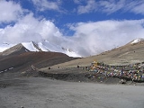
Taglang La, elevation 17582 feet (5,359 m), is a high mountain pass
in Ladakh
, India
.
It is sometimes incorrectly claimed to be the world’s second highest motorable pass at an altitude of 5,325 m. (17,469 feet). See the article on Khardung La
for a discussion of the world's highest motorable passes. It is, however, the second highest motorable mountain pass
in India after Khardung La
and is reached via 21 Gata loops. It is located along the Leh-Manali Highway
.
Mountain pass
A mountain pass is a route through a mountain range or over a ridge. If following the lowest possible route, a pass is locally the highest point on that route...
in Ladakh
Ladakh
Ladakh is a region of Jammu and Kashmir, the northernmost state of the Republic of India. It lies between the Kunlun mountain range in the north and the main Great Himalayas to the south, inhabited by people of Indo-Aryan and Tibetan descent...
, India
India
India , officially the Republic of India , is a country in South Asia. It is the seventh-largest country by geographical area, the second-most populous country with over 1.2 billion people, and the most populous democracy in the world...
.
It is sometimes incorrectly claimed to be the world’s second highest motorable pass at an altitude of 5,325 m. (17,469 feet). See the article on Khardung La
Khardung La
Khardung La is a high mountain pass located in the Ladakh region, Jammu and Kashmir, India...
for a discussion of the world's highest motorable passes. It is, however, the second highest motorable mountain pass
Mountain pass
A mountain pass is a route through a mountain range or over a ridge. If following the lowest possible route, a pass is locally the highest point on that route...
in India after Khardung La
Khardung La
Khardung La is a high mountain pass located in the Ladakh region, Jammu and Kashmir, India...
and is reached via 21 Gata loops. It is located along the Leh-Manali Highway
Leh-Manali Highway
The Leh-Manali Highway is a highway in India connecting Leh and Manali. It is open only between June and mid-September when snow is cleared from the road by the Border Roads Organisation. It connects the Manali valley to Kullu valley, Lahaul and Spiti and Ladakh...
.