

Tammany Trace
Encyclopedia
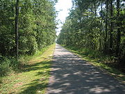
Rail trail
A rail trail is the conversion of a disused railway easement into a multi-use path, typically for walking, cycling and sometimes horse riding. The characteristics of former tracks—flat, long, frequently running through historical areas—are appealing for various development. The term sometimes also...
in Louisiana
Louisiana
Louisiana is a state located in the southern region of the United States of America. Its capital is Baton Rouge and largest city is New Orleans. Louisiana is the only state in the U.S. with political subdivisions termed parishes, which are local governments equivalent to counties...
occupying a former Illinois Central Railroad
Illinois Central Railroad
The Illinois Central Railroad , sometimes called the Main Line of Mid-America, is a railroad in the central United States, with its primary routes connecting Chicago, Illinois with New Orleans, Louisiana and Birmingham, Alabama. A line also connected Chicago with Sioux City, Iowa...
corridor.
It has been developed into a 31 miles (49.9 km) asphalt trail for hiking, cycling
Bicycle
A bicycle, also known as a bike, pushbike or cycle, is a human-powered, pedal-driven, single-track vehicle, having two wheels attached to a frame, one behind the other. A person who rides a bicycle is called a cyclist, or bicyclist....
, and wheelchair
Wheelchair
A wheelchair is a chair with wheels, designed to be a replacement for walking. The device comes in variations where it is propelled by motors or by the seated occupant turning the rear wheels by hand. Often there are handles behind the seat for someone else to do the pushing...
use with a parallel equestrian
Equestrianism
Equestrianism more often known as riding, horseback riding or horse riding refers to the skill of riding, driving, or vaulting with horses...
trail.
It connects Covington
Covington, Louisiana
Covington is a city in and the parish seat of St. Tammany Parish, Louisiana, United States. The population was 8,483 at the 2000 census. It is located at a fork of the Bogue Falaya and the Tchefuncte River....
, Abita Springs
Abita Springs, Louisiana
Abita Springs is a town in St. Tammany Parish, Louisiana, United States. The estimated population, in 2003, was 2,112. It is part of the New Orleans–Metairie–Kenner Metropolitan Statistical Area.-History:...
, Mandeville
Mandeville, Louisiana
Mandeville is a city in St. Tammany Parish, Louisiana, United States. The population was 12,421 in 2008. Mandeville is located on the North Shore of Lake Pontchartrain, south of Interstate 12. It is across the lake from the city of New Orleans and its southshore suburbs...
, Lacombe
Lacombe, Louisiana
Lacombe is a census-designated place in St. Tammany Parish, Louisiana, United States. The population was 7,518 at the 2000 census.-Geography:Lacombe is located at ....
, and Slidell
Slidell, Louisiana
Slidell is a city situated on the northeast shore of Lake Pontchartrain in St. Tammany Parish, Louisiana, United States. The population was 25,695 at the 2000 census. The Greater Slidell Community has a population of about 90,000...
running along the northshore of Lake Pontchartrain
Lake Pontchartrain
Lake Pontchartrain is a brackish estuary located in southeastern Louisiana. It is the second-largest inland saltwater body of water in the United States, after the Great Salt Lake in Utah, and the largest lake in Louisiana. As an estuary, Pontchartrain is not a true lake.It covers an area of with...
. The trail was damaged by Hurricane Katrina
Hurricane Katrina
Hurricane Katrina of the 2005 Atlantic hurricane season was a powerful Atlantic hurricane. It is the costliest natural disaster, as well as one of the five deadliest hurricanes, in the history of the United States. Among recorded Atlantic hurricanes, it was the sixth strongest overall...
but was reopened by early 2007.
Location
| Point | Coordinates |
|---|---|
| West end of the trail | 30.477°N 90.094°W |
| 59 trailhead/caboose | 30.417°N 90.044°W |
| Lafitte Gerard trailhead | 30.363°N 90.062°W |
| Lacombe trailhead | 30.309°N 89.930°W |
| Slidell/Carollo trailhead | 30.301°N 89.833°W |
| East end of the trail | 30.297°N 89.780°W |