
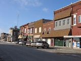
Tama, Iowa
Encyclopedia

Tama County, Iowa
-2010 census:The 2010 census recorded a population of 17,767 in the county, with a population density of . There were 7,766 housing units, of which 6,947 were occupied.-2000 census:...
, Iowa
Iowa
Iowa is a state located in the Midwestern United States, an area often referred to as the "American Heartland". It derives its name from the Ioway people, one of the many American Indian tribes that occupied the state at the time of European exploration. Iowa was a part of the French colony of New...
, United States
United States
The United States of America is a federal constitutional republic comprising fifty states and a federal district...
. The population was 2,731 at the 2000 census. Tama is located a few miles from the Meskwaki Settlement, Iowa's only significant Native American community. Tama was located on the historic Lincoln Highway
Lincoln Highway
The Lincoln Highway was the first road across the United States of America.Conceived and promoted by entrepreneur Carl G. Fisher, the Lincoln Highway spanned coast-to-coast from Times Square in New York City to Lincoln Park in San Francisco, originally through 13 states: New York, New Jersey,...
and is home to an original Lincoln Highway bridge, listed on the National Register of Historic Places
National Register of Historic Places
The National Register of Historic Places is the United States government's official list of districts, sites, buildings, structures, and objects deemed worthy of preservation...
. Tama is named for Taimah
Taimah
Taimah was an early 19th century Meskwaki leader. Often called Chief Tama in historical accounts.-Life:...
, the 19th century Meskwaki leader.
Tama is situated two miles south of Toledo
Toledo, Iowa
Toledo is a city in and the county seat of Tama County, Iowa, United States. The population was 2,539 at the 2000 census.-Geography:Toledo is located at ....
, the county seat
County seat
A county seat is an administrative center, or seat of government, for a county or civil parish. The term is primarily used in the United States....
. The two towns are close enough to have nearly grown together over the years.
Geography
Tama is located at 41°57′58"N 92°34′30"W (41.966149, -92.574990).According to the United States Census Bureau
United States Census Bureau
The United States Census Bureau is the government agency that is responsible for the United States Census. It also gathers other national demographic and economic data...
, the city has a total area of 3.2 square miles (8.3 km²), of which 3 square miles (7.8 km²) is land and 0.2 square mile (0.517997622 km²) (4.73%) is water.
Demographics
As of the censusCensus
A census is the procedure of systematically acquiring and recording information about the members of a given population. It is a regularly occurring and official count of a particular population. The term is used mostly in connection with national population and housing censuses; other common...
of 2000, there were 2,731 people, 1,065 households, and 723 families residing in the city. The population density
Population density
Population density is a measurement of population per unit area or unit volume. It is frequently applied to living organisms, and particularly to humans...
was 905.1 people per square mile (349.2/km²). There were 1,173 housing units at an average density of 388.7 per square mile (150.0/km²). The racial makeup of the city was 87.04% White, 0.40% African American, 4.80% Native American, 0.40% Asian, 5.24% from other races
Race (United States Census)
Race and ethnicity in the United States Census, as defined by the Federal Office of Management and Budget and the United States Census Bureau, are self-identification data items in which residents choose the race or races with which they most closely identify, and indicate whether or not they are...
, and 2.12% from two or more races. Hispanic or Latino of any race were 9.63% of the population.
There were 1,065 households out of which 33.2% had children under the age of 18 living with them, 51.6% were married couples
Marriage
Marriage is a social union or legal contract between people that creates kinship. It is an institution in which interpersonal relationships, usually intimate and sexual, are acknowledged in a variety of ways, depending on the culture or subculture in which it is found...
living together, 12.5% had a female householder with no husband present, and 32.1% were non-families. 28.1% of all households were made up of individuals and 16.5% had someone living alone who was 65 years of age or older. The average household size was 2.51 and the average family size was 3.08.
In the city the population was spread out with 27.4% under the age of 18, 8.1% from 18 to 24, 25.0% from 25 to 44, 20.7% from 45 to 64, and 18.8% who were 65 years of age or older. The median age was 37 years. For every 100 females there were 91.2 males. For every 100 females age 18 and over, there were 82.4 males.
The median income for a household in the city was $35,531, and the median income for a family was $43,750. Males had a median income of $33,672 versus $22,237 for females. The per capita income
Per capita income
Per capita income or income per person is a measure of mean income within an economic aggregate, such as a country or city. It is calculated by taking a measure of all sources of income in the aggregate and dividing it by the total population...
for the city was $16,676. About 8.8% of families and 12.3% of the population were below the poverty line, including 17.3% of those under age 18 and 16.9% of those age 65 or over.