
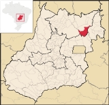
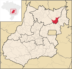
São João d'Aliança
Encyclopedia
| São João d'Aliança | |
|---|---|
| State | Goiás Goiás Goiás is a state of Brazil, located in the central part of the country. The name Goiás comes from the name of an indigenous community... |
| Coordinates: | 14°42′41"S 47°30′58"W |
| Area: | 3,327.3 km² |
| Population: | 8,177(IBGE 2007) |
| Population density | 2.46 inhab/km² |
| Urban population | 5,094 (2007) |
| Rural population | 3,083 (2007) |
| Elevation: | 986m |
| Postcode (CEP): | 73760-000 |
| IBGE statistical microregion: | 018 Chapada dos Veadeiros Chapada dos Veadeiros Microregion The Chapada dos Veadeiros Microregion is an IBGE statistical region in north-central Goiás state, Brazil. It includes 8 cities with a population of 60,267 in a total area of 21,476 km²... |
| Became a city: | 1953 |
| Mayor: | Vilmar Ferreira de Araújo |
| Distance to Goiânia Goiânia -Climate:The city has a tropical wet and dry climate with an average temperature of . There's a wet season, from October to April, and a dry one, from May to September. Annual rainfall is around 1,520 mm.... : |
357 km. |
| Website: | n/a |
Town
A town is a human settlement larger than a village but smaller than a city. The size a settlement must be in order to be called a "town" varies considerably in different parts of the world, so that, for example, many American "small towns" seem to British people to be no more than villages, while...
and municipality
Municipality
A municipality is essentially an urban administrative division having corporate status and usually powers of self-government. It can also be used to mean the governing body of a municipality. A municipality is a general-purpose administrative subdivision, as opposed to a special-purpose district...
in northeastern Goiás
Goiás
Goiás is a state of Brazil, located in the central part of the country. The name Goiás comes from the name of an indigenous community...
state, Brazil
Brazil
Brazil , officially the Federative Republic of Brazil , is the largest country in South America. It is the world's fifth largest country, both by geographical area and by population with over 192 million people...
. São João is a gateway to the Chapada dos Veadeiros National Park
Chapada dos Veadeiros National Park
Brazil's Chapada dos Veadeiros National Park is located in the Chapada dos Veadeiros, an ancient plateau with an estimated age of 1.8 billion years. Based in the Brazilian state of Goias, the Park was created on January 11, 1961 by President Juscelino Kubitscheck, and listed as a World Heritage...
. The name is sometimes written as São João D'Aliança.
Location
São João is located north of BrasíliaBrasília
Brasília is the capital city of Brazil. The name is commonly spelled Brasilia in English. The city and its District are located in the Central-West region of the country, along a plateau known as Planalto Central. It has a population of about 2,557,000 as of the 2008 IBGE estimate, making it the...
on state highway G0-118, which begins near Planaltina
Planaltina
Planaltina is one of the administrative districts of the Federal District of Brazil, with an area of 1,534 kmª and a population of 147,114 in 2000, of whom 134,663 were classified as urban and 12,451 as rural...
and connects with Alto Paraíso de Goiás
Alto Paraíso de Goiás
Alto Paraíso de Goiás is a small town and a municipality in northeastern Goiás state, Brazil. It has become known for its ecological and New Age tourism.-Location:...
. It is part of the Chapada dos Veadeiros Microregion
Chapada dos Veadeiros Microregion
The Chapada dos Veadeiros Microregion is an IBGE statistical region in north-central Goiás state, Brazil. It includes 8 cities with a population of 60,267 in a total area of 21,476 km²...
. The distance to the state capital, Goiânia
Goiânia
-Climate:The city has a tropical wet and dry climate with an average temperature of . There's a wet season, from October to April, and a dry one, from May to September. Annual rainfall is around 1,520 mm....
is 357 km. Highway connections from Goiânia
Goiânia
-Climate:The city has a tropical wet and dry climate with an average temperature of . There's a wet season, from October to April, and a dry one, from May to September. Annual rainfall is around 1,520 mm....
are made by BR-153 / Anápolis
Anápolis
Anápolis is the third largest city in the State of Goiás in Brazil. It lies in the center of a rich agricultural region and has become a leader in food processing and pharmaceutical plants.-Location and population:...
/ BR-060 / Alexânia
Alexânia
Alexânia is a small town and municipality in central Goiás state, Brazil. Alexânia is known for its alleged extraterrestrial sightings in the late sixties and early seventies. The Areias River passes through the municipality.-Location:...
/ Planaltina
Planaltina
Planaltina is one of the administrative districts of the Federal District of Brazil, with an area of 1,534 kmª and a population of 147,114 in 2000, of whom 134,663 were classified as urban and 12,451 as rural...
(DF) / GO-430 / Planaltina de Goiás
Planaltina de Goiás
Planaltina is a city located in the center of the state of Goiás, Brazil. Planaltina is often referred to as Planaltina de Goiás, but in official documents it is called Planaltina.-Location and Geography:...
(GO) / GO-118 / BR-010 /.
Neighboring municipalities are:
- North: Alto Paraíso de GoiásAlto Paraíso de GoiásAlto Paraíso de Goiás is a small town and a municipality in northeastern Goiás state, Brazil. It has become known for its ecological and New Age tourism.-Location:...
- South: FormosaFormosa, GoiásFormosa is a city and municipality located in the state of Goiás, Brazil, approximately 80 kilometers east of Brasília. The population was 90,247 in a total area of 5,806.89 km² . Formosa is known for its waterfalls and natural beauty...
and Água Fria de GoiásÁgua Fria de GoiásÁgua Fria de Goiás is a small town and municipality in northern Goiás state, Brazil.-Location:Água Fria became a city in 1989 when it was dismembered from Planaltina de Goiás in 1989. Água Fria is located in the microregion called Entorno de Brasília, although it is almost 156 kilometers to the... - East: Flores de GoiásFlores de GoiásFlores de Goiás is a small town and municipality in northeastern Goiás state, Brazil.-Geography:Located in the Vão do Paranã statistical micro-region, Flores has boundaries with Buritis, Sítio d'Abadia, Vila Boa, Alvorada do Norte, Iaciara, Nova Roma, São João d'Aliança, Formosa and Alto Paraíso...
- West: NiquelândiaNiquelândiaNiquelândia is a small city and municipality in northern Goiás state, Brazil. It is the largest municipality in the state in area and is an important producer of minerals.-Geography:...
The economy
The economy is based on agriculture (corn, soybeans, and manioc), cattle raising (64,800 head in 2006), services, public administration, and small transformation industries. The soils, altitude and climate are considered favorable for planting corn (7,000 hectares) and soybeans (19,000 hectares). Farmers harvest 15,000 sacks of corn per square kilometre, which is twice the national average. Usually corn is rotated with soybeans. There was one financial institution—Banco Itaú—in 2007.In 2006 there were 893 farms with a total area of 133,134 ha., of which 2,590 ha. were permanent crops, 27,673 ha. were perennial crops, and 71,332 ha. were natural pasture. There were 2,550 persons dependent on agriculture. The number of tractors was 259.
Health and education
- Hospitals: 01 with 24 beds (2007)
- Adult literacy rate: 84.0% (2000) (national average was 86.4%)
- Infant mortality rate: 26.56 (2000) (national average was 33.
- MHDI: 0.719
- State ranking: 177 (out of 242 municipalities)
- National ranking: 2,654 (out of 5,507 municipalities)
Tourism
Tourism has become important in recent years with the proximity of the Chapada dos Veadeiros National ParkChapada dos Veadeiros National Park
Brazil's Chapada dos Veadeiros National Park is located in the Chapada dos Veadeiros, an ancient plateau with an estimated age of 1.8 billion years. Based in the Brazilian state of Goias, the Park was created on January 11, 1961 by President Juscelino Kubitscheck, and listed as a World Heritage...
. There are several waterfalls in the region, with the Cachoeira Extrema or Label being the highest: 130 meters of direct fall. It is still quite inaccessible and it is necessary to walk three hours to reach it. The vegetation and fauna are very rich in the area. In the cerrado
Cerrado
The Cerrado, is a vast tropical savanna ecoregion of Brazil, particularly in the states of Gioas and Minas Gerais...
there are a minimum of 837 species of birds and 161 species of mammals.
History
São João began as a farm in the nineteenth century. In 1910, it was Arraial Capetinga, consisting of same grass huts, two houses covered with tiles, and a chapel dedicated to Saint John the Baptist. In 1931 it became a municipality only to revert to a district of Formosa in 1939. Finally in 1953 it was re-established as a municipality. With the construction of BrasíliaBrasília
Brasília is the capital city of Brazil. The name is commonly spelled Brasilia in English. The city and its District are located in the Central-West region of the country, along a plateau known as Planalto Central. It has a population of about 2,557,000 as of the 2008 IBGE estimate, making it the...
and a relative proximity to that important city, farmers from the south began to arrive and buy inexpensive land to plant soybeans.